
Thurston Island is an ice-covered, glacially dissected island, 215 km (134 mi) long, 90 km (56 mi) wide and 15,700 km2 (6,062 sq mi) in area, lying a short way off the northwest end of Ellsworth Land, Antarctica. It is the third-largest island of Antarctica, after Alexander Island and Berkner Island.
Gem Glacier is the smallest named glacier in Glacier National Park (U.S.). Located on the east side of the Continental Divide arête known as the Garden Wall, the glacier is situated on the cliff face above the better known Grinnell Glacier. Gem Glacier is a hanging glacier, and drapes down from the north face of the steep arete to which it is attached. Gem Glacier is only 5 acres (0.020 km2) in area and is far below the 25 acres (0.10 km2) threshold often cited as qualifying as an active glacier. Between 1966 and 2005, Gem Glacier lost 30 percent of its acreage and Grinnell Glacier lost 40 percent.
Downs Glacier is located in Shoshone National Forest, in the U.S. state of Wyoming on the east of the Continental Divide in the Wind River Range. The glacier is 1 mi (1.6 km) south of Downs Mountain and sits at an elevation of between 12,600 and 11,200 ft. Downs Glacier is one of many glaciers found in the Fitzpatrick Wilderness, and is part of the largest grouping of glaciers in the American Rocky Mountains.
Gooseneck Glacier is located in the Fitzpatrick Wilderness, Shoshone National Forest, in the US state of Wyoming. The glacier is east of the Continental Divide in the northern Wind River Range and on the southeast flank of Gannett Peak, the tallest mountain in Wyoming. Gooseneck Glacier is separated from Dinwoody Glacier by a rocky outcropping and they are part of the largest grouping of glaciers in the American Rocky Mountains.
Stroud Glacier is west of the Continental Divide in the northern Wind River Range in the U.S. state of Wyoming. The glacier is located in the Bridger Wilderness of Bridger-Teton National Forest, and is among the largest grouping of glaciers in the American Rocky Mountains. The glacier is situated in a north facing cirque, below the summit of Bow Mountain.
Twins Glacier is west of the Continental Divide in the northern Wind River Range in the U.S. state of Wyoming. The glacier is located in the Bridger Wilderness of Bridger-Teton National Forest, and is among the largest grouping of glaciers in the American Rocky Mountains. The glacier is situated in a northeast facing cirque, below the summit of Winifred Peak.
Heap Steep Glacier is located east of the Continental Divide in the northern Wind River Range in the US state of Wyoming. The glacier is situated in the Fitzpatrick Wilderness of Shoshone National Forest, and is among the largest grouping of glaciers in the American Rocky Mountains. Heap Steep Glacier is in a north facing cirque, below the summit of Sunbeam Peak. A large terminal moraine and small proglacial lake are located below the glacier.

Sacagawea Glacier is east of the Continental Divide in the northern Wind River Range in the U.S. state of Wyoming. The glacier is located in the Fitzpatrick Wilderness of Shoshone National Forest, and is among the largest grouping of glaciers in the American Rocky Mountains. Sacagawea Glacier flows to the east, from a northeast facing cirque, starting near the summit of Mount Sacagawea. A large moraine and small proglacial lake are situated beyond the terminal east end of the glacier.
Lower Fremont Glacier is east of the Continental Divide in the northern Wind River Range in the U.S. state of Wyoming. The glacier is in the Fitzpatrick Wilderness of Shoshone National Forest, and is among the largest grouping of glaciers in the American Rocky Mountains. Lower Fremont Glacier flows to the southeast and the rapid retreat of this glacier has left behind lateral moraines and a proglacial lake. Lower Fremont Glacier is separated from the Bull Lake Glacier by a moraine and from the Upper Fremont Glacier by cliffs.
Bull Lake Glacier is located immediately east of the Continental Divide in the northern Wind River Range in the U.S. state of Wyoming. The glacier is in the Fitzpatrick Wilderness of Shoshone National Forest, and is among the largest grouping of glaciers in the American Rocky Mountains. Bull Lake Glacier flows to the east and starts below the summit of Jackson Peak. It is adjacent to Lower Fremont Glacier though the two are separated by a moraine.
Harrower Glacier is located on the west side of the Continental Divide in the northern Wind River Range in the US state of Wyoming. The glacier is in the Bridger Wilderness of Bridger-Teton National Forest, and is among the largest grouping of glaciers in the American Rocky Mountains. Harrower Glacier flows to the north and is situated in a cirque, below the summit of Knife Point Mountain.
Washakie Glacier is on the east side of the Continental Divide in the southern Wind River Range in the U.S. state of Wyoming. The glacier is in the Popo Agie Wilderness of Shoshone National Forest. Washakie Glacier is situated in a north facing cirque between Mount Washakie and Bair Peak.

Grant Glacier is located in the US state of Montana in Flathead National Forest. The glacier is situated in a cirque and lies below the east slopes of Mount Grant. Grant Glacier is 1 mile (1.6 km) southeast of Stanton Glacier and both 5 miles (8.0 km) west of Glacier National Park (U.S.). Images taken of the glacier in 1902 and from the same vantage point in 1998 indicate that the glacier retreated substantially during the 20th Century.

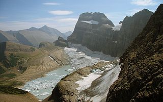
Ahern Glacier is in Glacier National Park in the U.S. state of Montana. The glacier was named after George Patrick Ahern. Ahern Glacier is situated on a ridge between Ipasha Peak to the north and Ahern Peak to the south at an elevation between 8,800 feet (2,700 m) and 8,000 feet (2,400 m) above sea level, immediately east of the Continental Divide. Meltwater from the glacier feeds Ahern Glacier Falls, a waterfall which descends an estimated 1,680 feet (510 m) in one sheer drop to a talus slope below en route to Helen Lake. Between 1966 and 2005, Ahern Glacier lost 13 percent of its surface area.
Dixon Glacier is located in the U.S. state of Montana in Glacier National Park. The glacier is situated in a cirque immediately to the north of The Sentinel at an elevation between 8,500 feet (2,600 m) and 7,400 feet (2,300 m) above sea level. Immediately east of the Continental Divide, the glacier is 1 mi (1.6 km) east of Thunderbird Glacier. Dixon Glacier covers an area of approximately 59 acres (0.24 km2) and between 1966 and 2005 lost over 45 percent of its surface area.
Hale Glacier is a glacier about 6 nautical miles (11 km) long, located just east of Mount Simpson on Thurston Island, Antarctica, and flowing southwest to the Abbot Ice Shelf in Peacock Sound. It was delineated from air photos taken by U.S. Navy Squadron VX-6 in January 1960, and was named by the Advisory Committee on Antarctic Names (US-ACAN) for Lieutenant Bill J. Hale, U.S. Navy, a helicopter pilot aboard USS Burton Island who made exploratory flights to Thurston Island in February 1960.
Isabelle Glacier is an alpine glacier located .25 mi (0.40 km) southwest of Shoshoni Peak, in Roosevelt National Forest in the US state of Colorado. The glacier is immediately east of the Continental Divide on the opposite side of the divide from Fair Glacier. Isabelle Glacier is the source of the South Saint Vrain Creek and can be reach by trail and is a 8.4 mi (13.5 km) round-trip hike from the trailhead.
The Saint Vrain Glaciers are small alpine glaciers located in Roosevelt National Forest in the U.S. state of Colorado. The glaciers are just south of Rocky Mountain National Park and east of the Continental Divide in northeast facing cirques.
Taylor Glacier is a small cirque glacier in Rocky Mountain National Park in the U.S. state of Colorado. Taylor Glacier is on the east side of the Continental Divide and adjacent to Taylor Peak. Taylor Glacier is both an ice and a rock glacier, with the lower portions of the glacier being composed primarily of rock debris and a small portion of ice.
Sphinx Glacier is in the Wind River Range, Bridger-Teton National Forest, in the U.S. state of Wyoming. The glacier is situated on the southern slope of Mount Woodrow Wilson and immediately west of the Continental Divide. The glacier is flanked on the east by a mountain known as The Sphinx. Sphinx Glacier is on the opposite side of the Continental Divide from Dinwoody Glacier.


