Gooseneck Glacier is located in the Fitzpatrick Wilderness, Shoshone National Forest, in the US state of Wyoming. The glacier is east of the Continental Divide in the northern Wind River Range and on the southeast flank of Gannett Peak, the tallest mountain in Wyoming. Gooseneck Glacier is separated from Dinwoody Glacier by a rocky outcropping and they are part of the largest grouping of glaciers in the American Rocky Mountains.

Stroud Glacier is west of the Continental Divide in the northern Wind River Range in the U.S. state of Wyoming. The glacier is located in the Bridger Wilderness of Bridger-Teton National Forest, and is among the largest grouping of glaciers in the American Rocky Mountains. The glacier is situated in a north facing cirque, below the summit of Bow Mountain.
Twins Glacier is west of the Continental Divide in the northern Wind River Range in the U.S. state of Wyoming. The glacier is located in the Bridger Wilderness of Bridger-Teton National Forest, and is among the largest grouping of glaciers in the American Rocky Mountains. The glacier is situated in a northeast facing cirque, below the summit of Winifred Peak.
Heap Steep Glacier is located east of the Continental Divide in the northern Wind River Range in the US state of Wyoming. The glacier is situated in the Fitzpatrick Wilderness of Shoshone National Forest, and is among the largest grouping of glaciers in the American Rocky Mountains. Heap Steep Glacier is in a north facing cirque, below the summit of Sunbeam Peak. A large terminal moraine and small proglacial lake are located below the glacier.

Helen Glacier is located east of the Continental Divide in the northern Wind River Range in the US state of Wyoming. The glacier is located in the Fitzpatrick Wilderness of Shoshone National Forest, and is among the largest grouping of glaciers in the American Rocky Mountains. Helen Glacier flows to the east from a cirque to the northeast of Mount Helen.

Sacagawea Glacier is east of the Continental Divide in the northern Wind River Range in the U.S. state of Wyoming. The glacier is located in the Fitzpatrick Wilderness of Shoshone National Forest, and is among the largest grouping of glaciers in the American Rocky Mountains. Sacagawea Glacier flows to the east, from a northeast facing cirque, starting near the summit of Mount Sacagawea. A large moraine and small proglacial lake are situated beyond the terminal east end of the glacier.
Lower Fremont Glacier is east of the Continental Divide in the northern Wind River Range in the U.S. state of Wyoming. The glacier is in the Fitzpatrick Wilderness of Shoshone National Forest, and is among the largest grouping of glaciers in the American Rocky Mountains. Lower Fremont Glacier flows to the southeast and the rapid retreat of this glacier has left behind lateral moraines and a proglacial lake. Lower Fremont Glacier is separated from the Bull Lake Glacier by a moraine and from the Upper Fremont Glacier by cliffs.
Harrower Glacier is located on the west side of the Continental Divide in the northern Wind River Range in the US state of Wyoming. The glacier is in the Bridger Wilderness of Bridger-Teton National Forest, and is among the largest grouping of glaciers in the American Rocky Mountains. Harrower Glacier flows to the north and is situated in a cirque, below the summit of Knife Point Mountain.

Tyndall Glacier is a small cirque glacier in Rocky Mountain National Park in the U.S. state of Colorado. Tyndall Glacier is on the east side of the Continental Divide and in a cirque to the north of Hallett Peak. Tyndall Glacier is both an ice and a rock glacier, with the lower portions of the glacier being composed primarily of rock debris and a small portion of ice.

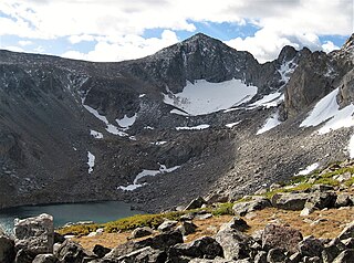
Wind River Glacier is in the Wind River Range, Shoshone National Forest, in the U.S. state of Wyoming. The glacier is situated on the northeast slope of Wind River Peak, the tallest peak in the southern Wind River Range.
Mills Glacier is an alpine glacier near the base of the east mountain face of Longs Peak, in Rocky Mountain National Park in the U.S. state of Colorado.
Moomaw Glacier is an alpine glacier in Rocky Mountain National Park in the U.S. state of Colorado. Moomaw Glacier is almost 1 mi (1.6 km) northeast of Isolation Peak and the old terminal moraine of the glacier impounds Frigid Lake.
Taylor Glacier is a small cirque glacier in Rocky Mountain National Park in the U.S. state of Colorado. Taylor Glacier is on the east side of the Continental Divide and adjacent to Taylor Peak. Taylor Glacier is both an ice and a rock glacier, with the lower portions of the glacier being composed primarily of rock debris and a small portion of ice.
The Dove is a small cirque glacier or perennial snowfield located in Rocky Mountain National Park in the U.S. state of Colorado. The Dove is on the north slope of Longs Peak and near The Keyhole, which is along a popular climbing route to the summit.
Sphinx Glacier is in the Wind River Range, Bridger-Teton National Forest, in the U.S. state of Wyoming. The glacier is situated on the southern slope of Mount Woodrow Wilson and immediately west of the Continental Divide. The glacier is flanked on the east by a mountain known as The Sphinx. Sphinx Glacier is on the opposite side of the Continental Divide from Dinwoody Glacier.
Tiny Glacier is in the Wind River Range, Bridger-Teton National Forest, in the U.S. state of Wyoming. The glacier is situated in a north-facing cirque immediately west of the Continental Divide.

Mount Washakie is located in the Wind River Range in the U.S. state of Wyoming. The mountain is on the Continental Divide in the Bridger Wilderness of Bridger-Teton National Forest and Popo Agie Wilderness of Shoshone National Forest. Washakie Glacier lies .50 mi (0.80 km) to the southeast of the peak.
Bair Peak is located in the Wind River Range in the U.S. state of Wyoming. The mountain is on the Continental Divide in the Bridger Wilderness of Bridger-Teton National Forest and Popo Agie Wilderness of Shoshone National Forest. Washakie Glacier lies on the north slopes of the peak.
Washakie Needles is the highest peak in the Washakie Range in the U.S. state of Wyoming. Washakie Needles is in the Washakie Wilderness of Shoshone National Forest. The Washakie Range is one of the southern group of mountains within the Absaroka Range, the other being the Owl Creek Mountains. Washakie Needles is only .8 mi (1.3 km) south of the slightly lower Dome Mountain, the second tallest peak in the Washakie Range. Part of the Absaroka volcanic field, the dacites that comprise the summit needles or pillars on Washakie Needles have been dated at 38.8 million years old, and are the youngest volcanic rocks associated with the Absarokas.
Dome Mountain is the highest peak in the Washakie Range in the U.S. state of Wyoming. Dome Mountain is in the Washakie Wilderness of Shoshone National Forest.
