
The Priestley Glacier is a major valley glacier, about 60 nautical miles long, originating at the edge of the Polar Plateau of Victoria Land, Antarctica. The glacier drains southeast between the Deep Freeze Range and Eisenhower Range to enter the northern end of the Nansen Ice Sheet. It was first explored by the Northern Party of the British Antarctic Expedition, 1910–13, and named for Raymond Priestley, a geologist with the Northern Party.
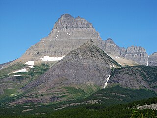
Mount Wilbur is located in the Lewis Range, Glacier National Park in the U.S. state of Montana. Plainly visible from the region of Many Glacier, the peak rises over 4,500 feet (1,372 m) above Swiftcurrent Lake and is a steep pyramid on three sides. The west slopes of the peak join to ridges along the continental divide. Much of the climbing routes are rated at class 4 to 5, with some only used once. The sedimentary rock of the mountains makes for often poor anchoring points and enhances the difficulty. A cirque on the north slopes of the mountain shelters Iceberg Lake, a popular hiking destination from Many Glacier. The mountain was named by George Bird Grinnell in 1885, for Edward R. Wilbur of New York, one of Grinnell's partners in the Forest and Stream Publishing Company, and both men were founders of the Audubon Society.
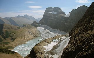
Gem Glacier is the smallest named glacier in Glacier National Park (U.S.). Located on the east side of the Continental Divide arête known as the Garden Wall, the glacier is situated on the cliff face above the better known Grinnell Glacier. Gem Glacier is a hanging glacier, and drapes down from the north face of the steep arete to which it is attached. Gem Glacier is only 5 acres (0.020 km2) in area and is far below the 25 acres (0.10 km2) threshold often cited as qualifying as an active glacier. Between 1966 and 2005, Gem Glacier lost 30 percent of its acreage and Grinnell Glacier lost 40 percent.

Static Peak is located in the Teton Range, Grand Teton National Park, in the U.S. state of Wyoming. Located .48 miles (0.77 km) southeast of Buck Mountain, the summit is also east of the Alaska Basin Trail, from a point known as Static Peak Divide, the summit can be climbed in a scramble. Below the summit on the north face, a small remnant glacier persists, sheltered from direct sunlight by steep cliffs. Timberline Lake lies to the north of the peak.

Teton Glacier is a mountain glacier located below the north face of Grand Teton in Grand Teton National Park, Wyoming, United States. Its neighbors are Mount Owen to the west and Teewinot Mountain 12,330 feet (3,758 m) to the north.

Fryingpan Glacier is on the eastern face of the 11,138-foot (3,395 m) Little Tahoma Peak, just to the east of Mount Rainier in the U.S. state of Washington. The glacier is located on top of a cliff from the Emmons Glacier to the north and a small ridge separates this glacier from the Whitman Glacier to the south, except for a small snowfield in which these two glaciers are connected. Most of the ice is located on a broad plateau at an elevation of 8,000 to 8,600 feet. The head of the Fryingpan Glacier is located to the northeast of the ridge and at the foothill of Little Tahoma Peak at around 9,100 to 9,800 feet. The glacier flows downhill eastward and the uneven topography causes the glacier surface to be crevassed The glacier ends on shallow to steep slopes at about 7,100 to 7,500 feet. Numerous snowfields and alpine meadows are located near the bottom and east of the glacier. Meltwater from the glacier drains into the White River.

Stroud Glacier is west of the Continental Divide in the northern Wind River Range in the U.S. state of Wyoming. The glacier is located in the Bridger Wilderness of Bridger-Teton National Forest, and is among the largest grouping of glaciers in the American Rocky Mountains. The glacier is situated in a north facing cirque, below the summit of Bow Mountain.
Twins Glacier is west of the Continental Divide in the northern Wind River Range in the U.S. state of Wyoming. The glacier is located in the Bridger Wilderness of Bridger-Teton National Forest, and is among the largest grouping of glaciers in the American Rocky Mountains. The glacier is situated in a northeast facing cirque, below the summit of Winifred Peak.

Helen Glacier is located east of the Continental Divide in the northern Wind River Range in the US state of Wyoming. The glacier is located in the Fitzpatrick Wilderness of Shoshone National Forest, and is among the largest grouping of glaciers in the American Rocky Mountains. Helen Glacier flows to the east from a cirque to the northeast of Mount Helen.

Sacagawea Glacier is east of the Continental Divide in the northern Wind River Range in the U.S. state of Wyoming. The glacier is located in the Fitzpatrick Wilderness of Shoshone National Forest, and is among the largest grouping of glaciers in the American Rocky Mountains. Sacagawea Glacier flows to the east, from a northeast facing cirque, starting near the summit of Mount Sacagawea. A large moraine and small proglacial lake are situated beyond the terminal east end of the glacier.
Bull Lake Glacier is located immediately east of the Continental Divide in the northern Wind River Range in the U.S. state of Wyoming. The glacier is in the Fitzpatrick Wilderness of Shoshone National Forest, and is among the largest grouping of glaciers in the American Rocky Mountains. Bull Lake Glacier flows to the east and starts below the summit of Jackson Peak. It is adjacent to Lower Fremont Glacier though the two are separated by a moraine.
Knife Point Glacier is on the east side Continental Divide in the northern Wind River Range in the U.S. state of Wyoming. The glacier is in the Fitzpatrick Wilderness of Shoshone National Forest, and is among the largest grouping of glaciers in the American Rocky Mountains. Knife Point Glacier flows to the north and starts below the summit of Knife Point Mountain.
Harrower Glacier is located on the west side of the Continental Divide in the northern Wind River Range in the US state of Wyoming. The glacier is in the Bridger Wilderness of Bridger-Teton National Forest, and is among the largest grouping of glaciers in the American Rocky Mountains. Harrower Glacier flows to the north and is situated in a cirque, below the summit of Knife Point Mountain.

Iceberg Peak is located in the Lewis Range, Glacier National Park in the U.S. state of Montana. Iceberg Peak rises more than 3,000 feet (910 m) above Iceberg Lake and is considered a difficult climb due to the steepness and exposure climbers must endure. The peak sits astride the continental divide 1.1 mi (1.8 km) WNW of Mount Wilbur.

Red Eagle Glacier is a glacier remnant (glacieret) in Glacier National Park in the U.S. state of Montana. The glacieret is a hanging glacier located on the north slope of Clyde Peak, and to the southeast of Mount Logan and Logan Glacier. Between 1966 and 2005, Red Eagle Glacier lost 53 percent of its surface area and now covers less than 25 acres (0.10 km2) which is below the threshold to qualify as an active glacier. Comparing images of the glacier taken in 1914 with those from 2009, indicates that the glacier has experienced extensive retreat.
The McDonald Glacier is in the U.S. state of Montana. The glacier is in the Mission Mountains at an elevation of 8,600 feet (2,600 m) above sea level and is immediately north of McDonald Peak. The glacier covers approximately 45 acres (0.18 km2) and is located in a cirque below McDonald Peak.

Donnellan Glacier is a steep valley glacier fed by highland ice adjacent to Opalchenie Peak and Fukushima Peak on Vinson Plateau, the summit plateau of Vinson Massif, in the Sentinel Range of the Ellsworth Mountains, Antarctica. The glacier flows west-southwestward from Opalchenie Peak along the northwest side of Mount Slaughter into Nimitz Glacier.
The Dove is a small cirque glacier or perennial snowfield located in Rocky Mountain National Park in the U.S. state of Colorado. The Dove is on the north slope of Longs Peak and near The Keyhole, which is along a popular climbing route to the summit.

Boston Glacier is located in a large cirque below several mountain peaks in North Cascades National Park in the U.S. state of Washington. Approximately 1 mi (1.6 km) long but nearly 3.5 mi (5.6 km) wide, it is the largest glacier in North Cascades National Park. Extending in an arc from the north of Forbidden Peak, it is flanked by Boston Peak to the southwest and Buckner Mountain at its eastern margin, between which it lies below the arête known as Ripsaw Ridge. Another arête extending between Boston Peak, Sharkfin Tower, Forbidden Peak and further north separate Boston Glacier from the nearly adjoining Quien Sabe and Forbidden Glaciers. Boston Glacier has been in an overall state of retreat since the end of the Little Ice Age around the year 1850. A moderate advance occurred between 1950 and the mid-1970s; however, the retreat resumed and between 1972 and 2006 its terminus retreated 1,470 ft (450 m).
Sunbeam Peak is located in the Wind River Range in the U.S. state of Wyoming. The peak is the 13th highest summit in Wyoming. The summit is located in Shoshone National Forest and the Heap Steep Glacier lies on the north slopes of the mountain.
