
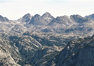
Gannett Peak is the highest mountain peak in the U.S. state of Wyoming at 13,810 feet (4,210 m). It lies in the Wind River Range within the Bridger Wilderness of the Bridger-Teton National Forest. Straddling the Continental Divide along the boundary between Fremont and Sublette counties, it has the second greatest topographic prominence in the state (7076') after Cloud Peak (7077'), and is the highest ground for 290.36 miles in any direction.

Fremont Peak is the third highest peak in the state of Wyoming, surpassed only by Gannett Peak and Grand Teton, and straddles the boundary between Fremont and Sublette counties in the Wind River Range. It is named for American explorer John C. Frémont who climbed the peak with Charles Preuss and Johnny Janisse from August 13 to August 15, 1842. Kit Carson had been with the climbing party on its first attempt at the peak, but had gone back for supplies the day Fremont and his men reached the summit. Carson is thought by some to have been the first to climb neighboring Jackson Peak. At that time, Fremont Peak was mistakenly thought to be the highest mountain in the Rocky Mountains, although there are actually over 100 higher peaks in the Rocky Mountain range.

Gannett Glacier is the largest glacier in the Rocky Mountains within the United States. The glacier is located on the east and north slopes of Gannett Peak, the highest mountain in Wyoming, on the east side of the Continental Divide in the Wind River Range. Gannett is but one of dozens of glaciers located in the Fitzpatrick Wilderness of Shoshone National Forest.

Upper Fremont Glacier is in the Fitzpatrick Wilderness of Shoshone National Forest in the U.S. state of Wyoming. This Wind River Range alpine glacier is associated with the largest grouping of glaciers in the U.S. Rocky Mountains and lies on the north slope of Fremont Peak, the third tallest mountain in Wyoming. Upper Fremont Glacier is at an average altitude of 13,450 ft (4,100 m) and is one of the highest altitude glaciers in the American Rockies.

Mount Helen is located in the Wind River Range in the U.S. state of Wyoming. The peak is the fourth highest peak in the range and the fifth tallest in Wyoming. The summit is located in the Bridger Wilderness of Bridger-Teton National Forest, immediately west of the Continental Divide. The eastern flanks of the mountain are covered in snowfields and glaciers, including Helen and Sacagawea Glaciers, all of which are in the Fitzpatrick Wilderness of Shoshone National Forest.
Turret Peak is the sixth-highest peak in the U.S. state of Wyoming and the fifth-highest in the Wind River Range. The Dinwoody Glacier is located on the northwest slope of the mountain, while the Helen Glacier is to the south. Turret Peak is estimated to be between 13,606 to 13,646 feet high.

Mount Sacagawea is the eighth-highest peak in the U.S. state of Wyoming and the seventh-highest in the Wind River Range. It was named after Sacagawea, the young Lemhi Shoshone woman who accompanied the Lewis and Clark Expedition as an interpreter and guide. The Upper Fremont Glacier is located southeast and the Sacagawea Glacier is northeast of the mountain. Straddling the Continental Divide, Mount Sacagawea is one mile (1.6 km) northwest of Fremont Peak.
Jackson Peak 13,523 feet (4,122 m) is the eighth-highest peak in the U.S. state of Wyoming and the seventh-highest in the Wind River Range. The Bull Lake Glacier is located immediately north and east of the mountain. Situated on the Continental Divide, Jackson Peak is .75 miles (1.21 km) southeast of Fremont Peak.
Baby Glacier is in the Bridger Wilderness of Bridger-Teton National Forest, in the U.S. state of Wyoming. The glacier is immediately west of the much larger Mammoth Glacier, both of which are on the west side of the Continental Divide in the northern Wind River Range. The glacier occupies a north facing cirque and flows northward from the slopes of Mount Whitecap. Baby Glacier is in the Bridger Wilderness and is part of the largest grouping of glaciers in the American Rocky Mountains.
Heap Steep Glacier is located east of the Continental Divide in the northern Wind River Range in the US state of Wyoming. The glacier is situated in the Fitzpatrick Wilderness of Shoshone National Forest, and is among the largest grouping of glaciers in the American Rocky Mountains. Heap Steep Glacier is in a north facing cirque, below the summit of Sunbeam Peak. A large terminal moraine and small proglacial lake are located below the glacier.

Helen Glacier is located east of the Continental Divide in the northern Wind River Range in the US state of Wyoming. The glacier is located in the Fitzpatrick Wilderness of Shoshone National Forest, and is among the largest grouping of glaciers in the American Rocky Mountains. Helen Glacier flows to the east from a cirque to the northeast of Mount Helen.
Sacagawea Glacier is east of the Continental Divide in the northern Wind River Range in the U.S. state of Wyoming. The glacier is located in the Fitzpatrick Wilderness of Shoshone National Forest, and is among the largest grouping of glaciers in the American Rocky Mountains. Sacagawea Glacier flows to the east, from a northeast facing cirque, starting near the summit of Mount Sacagawea. A large moraine and small proglacial lake are situated beyond the terminal east end of the glacier.
Lower Fremont Glacier is east of the Continental Divide in the northern Wind River Range in the U.S. state of Wyoming. The glacier is in the Fitzpatrick Wilderness of Shoshone National Forest, and is among the largest grouping of glaciers in the American Rocky Mountains. Lower Fremont Glacier flows to the southeast and the rapid retreat of this glacier has left behind lateral moraines and a proglacial lake. Lower Fremont Glacier is separated from the Bull Lake Glacier by a moraine and from the Upper Fremont Glacier by cliffs.
Bull Lake Glacier is located immediately east of the Continental Divide in the northern Wind River Range in the U.S. state of Wyoming. The glacier is in the Fitzpatrick Wilderness of Shoshone National Forest, and is among the largest grouping of glaciers in the American Rocky Mountains. Bull Lake Glacier flows to the east and starts below the summit of Jackson Peak. It is adjacent to Lower Fremont Glacier though the two are separated by a moraine.
Harrower Glacier is located on the west side of the Continental Divide in the northern Wind River Range in the US state of Wyoming. The glacier is in the Bridger Wilderness of Bridger-Teton National Forest, and is among the largest grouping of glaciers in the American Rocky Mountains. Harrower Glacier flows to the north and is situated in a cirque, below the summit of Knife Point Mountain.
Bastion Peak, at 13,500 feet (4,100 m), is located in the Wind River Range in the U.S. state of Wyoming. The peak is the ninth-highest in the range and the tenth-highest in Wyoming. The summit is located on the Continental Divide and the eastern slopes of the mountain are covered by a section of Gannett Glacier, the largest glacier in the American Rocky Mountains. An arête to the northeast leads to Bastion Peak-Northeast Peak, which, at 13,476 ft (4,107 m), is also one of the highest points in Wyoming.
Sunbeam Peak is located in the Wind River Range in the U.S. state of Wyoming. The peak is the 13th highest summit in Wyoming. The summit is located in Shoshone National Forest and the Heap Steep Glacier lies on the north slopes of the mountain.
Knife Point Mountain is located in the northern Wind River Range in the U.S. state of Wyoming. Situated 2.7 mi (4.3 km) southeast of Fremont Peak, Knife Point Mountain is on the Continental Divide. North of Knife Point Mountain is the origination point of Knife Point Glacier, while Harrower Glacier lies just to the west. Knife Point Mountain is the 32nd tallest peak in Wyoming.
American Legion Peak is located in the northern Wind River Range in the U.S. state of Wyoming. Situated 1 mi (1.6 km) east of Bow Mountain and a couple miles west of Mount Helen, American Legion Peak is the 17th tallest peak in Wyoming. The small American Legion Glacier descends from the east slopes of the mountain and Henderson Peak lies to the south.
