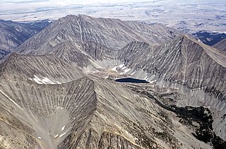
Continental Glacier is in Bridger-Teton and Shoshone National Forests, in the U.S. state of Wyoming and straddles the Continental Divide in the northern Wind River Range. Continental Glacier is in both the Bridger and Fitzpatrick Wildernesses, and is part of the largest grouping of glaciers in the American Rocky Mountains. Continental Glacier is situated at an elevation range of 13,100 to 11,200 feet and forms a nearly unbroken icefield over 3 miles (4.8 km) in length along a high altitude plateau to the north of Downs Mountain. Immediately east of Continental Glacier lies East Torrey Glacier.

Mount Ouray is a high and prominent mountain summit in the far southern Sawatch Range of the Rocky Mountains of North America. The 13,961-foot (4255.4 m) thirteener is located in San Isabel National Forest, 7.5 miles (12.0 km) west of Poncha Pass, Colorado, United States, on the boundary between Chaffee and Saguache counties. The mountain was named in honor of Ute Chief Ouray.

Mount Stimson is the second highest peak in Glacier National Park, located in Montana, United States. It is part of the Lewis Range, which spans much of the park. It is located in the remote southwestern portion of the park, approximately 5 miles (8.0 km) west of the Continental Divide and 12 miles (19 km) southeast of Lake McDonald. It is drained by Pinchot Creek and Nyack Creek, both of which flow into the Middle Fork of the Flathead River. The mountain is named for Henry L. Stimson (1867–1950), former U.S. Secretary of State and twice Secretary of War, who hiked and assisted George Bird Grinnell survey the area in and around Glacier National Park in the 1890s, and supported efforts to establish the national park.
Crazy Peak, elevation 11,214 ft (3,418 m), is the highest peak in the Crazy Mountains, an island range of the Montana Rockies, in the United States. Crazy Peak dominates the surroundings, rising over 7,000 feet (2,100 m) above the Yellowstone River Valley, and is the highest peak in Montana north of the Beartooth Mountains, which are 50 miles (80 km) to the south. Crazy Peak is also the most topographically prominent peak in Montana. A small glacier exists on the northeast slope of the mountain. The mountain is located on private land within the Gallatin National Forest.

Palmer Glacier is an extinct glacier on the south slopes of Mount Hood in the U.S. state of Oregon. With glacial ice movement having stopped in the mid-1980s, it is now considered a snowfield rather than an active glacier. The former glacier, now snowfield, is situated at an elevation range of 9,300 to 6,200 feet, and was named for Joel Palmer, an Oregon pioneer. Palmer Glacier is the most well-known of the twelve glaciers on the mountain, despite no longer technically qualifying as a glacier, and is a popular destination for snowsports enthusiasts as it is the only US resort that consistently runs its chairlifts from winter through summer.

Kintla Peak is a pyramidal peak in the Livingston Range of Glacier National Park in the U.S. state of Montana. It is the tallest mountain in the Livingston Range and the third-tallest in the park. It is also the most northerly peak and land area in the contiguous United States above 10,000 ft (3,000 m). The Agassiz Glacier lies below it to the southeast.
Mount Isolation is a mountain located in Coos County, New Hampshire. The mountain is part of the Presidential Range of the White Mountains. Mount Isolation is the highest peak on the Montalban Ridge which extends south from Boott Spur.

The Coalman Glacier is a glacier located on the upper slopes of Mount Hood in the U.S. state of Oregon. It is the mountain's highest glacier ranging from about 11,200 to 10,500 ft, located within the crater rim, southwest of the peak. It was named for Elija Coalman, an early mountain guide who climbed Mount Hood 586 times.

Lolo Peak is a 9,143 feet (2,787 m) mountain in the Bitterroot Range of western Montana, United States. It is in Missoula County, southwest of Missoula.

Mount Jackson is located in the Lewis Range, Glacier National Park in the U.S. state of Montana. Mount Jackson is the fourth tallest mountain in Glacier National Park and it is situated on the Continental Divide. Both the mountain and its namesake Jackson Glacier are easily seen from the Going-to-the-Sun Road. Harrison Glacier, the park's largest remaining glacier, is located on the mountain's southern flank. Based on the Köppen climate classification, Mount Jackson has an alpine climate characterized by long, usually very cold winters, and short, cool to mild summers. Temperatures can drop below −10 °F with wind chill factors below −30 °F.

Reid Glacier is an alpine glacier located on the west slope of Mount Hood in the U.S. state of Oregon. It ranges in elevation from about 9,800 to 6,000 feet. The glacier is the source of the Sandy River. The upper extent of the glacier is known for extensive crevasses.

Long Knife Peak is located in the Clark Range, Glacier National Park in the U.S. state of Montana. Though much of the mountain slopes extend into the Canadian Province of British Columbia, the main summit is in the U.S. Long Knife Peak rises more than a vertical 1 mile (1.6 km) above Upper Kintla Lake. It is also the most northerly peak and land area in the contiguous United States above 9,000 feet (2,743 m). Long Knife Peak is on an east west ridgeline identified as the "Boundary Mountains" on the USGS 7.5 minute topo quad and this extended ridge, with peak 8864, also contains the most northerly named (numbered) peak and land area in the contiguous United States above 8,000 feet (2,438 m).
Mount Carter is located in the Livingston Range, Glacier National Park in the U.S. state of Montana. Rainbow Glacier is just south of Mount Carter while Weasel Collar Glacier is immediately northeast. Mount Carter is the tenth tallest peak in Glacier National Park.

McDonald Peak, elevation 9,820 feet (2,993 m), is located in the U.S. state of Montana and is the highest peak in the Mission Mountains. McDonald Peak is situated within the Flathead Indian Reservation. The peak has the second greatest topographic prominence of all summits within Montana and is almost 80 miles (130 km) away from the next highest mountain in the state. McDonald Glacier is on the north slope of the peak.
Klickitat Glacier is located on the east slopes of Mount Adams a stratovolcano in the U.S. state of Washington. Though within the Mount Adams Wilderness, the glacier is situated within the boundaries of the Yakama Indian Reservation. The glacier descends from approximately 12,000 ft (3,700 m) to a terminus near 7,200 ft (2,200 m) below which an old lateral moraine once was the northern margin of the glacier. Klickitat Glacier has been in a general state of retreat for over 100 years and lost 46 percent of its surface area between 1904 and 2006.

Mazama Glacier is located on the southeast slopes of Mount Adams, a stratovolcano in the U.S. state of Washington. Mazama Glacier is in the Yakama Indian Reservation. The glacier descends from approximately 10,800 ft (3,300 m) to a terminus near 7,600 ft (2,300 m). Mazama Glacier has been in a general state of retreat for over 100 years and lost 46 percent of its surface area between 1904 and 2006.

Gilbert Peak (8,184 feet is located in the Goat Rocks on the border of the Yakama Indian Reservation and Yakima County, in the U.S. state of Washington. Situated partly in the Goat Rocks Wilderness, Gilbert Peak is the highest summit in the Goat Rocks, which are the eroded remnants of an extinct stratovolcano. Meade Glacier is located on the southeastern slopes of the peak, while Conrad Glacier is on the north slope.

Mount Logan is located in North Cascades National Park in the U.S. state of Washington. Mount Logan is in a remote location of North Cascades National Park that requires hiking 20 mi (32 km) from a trailhead to reach the peak. The mountain itself is not a difficult climb, though the easiest approaches require traversing glaciers and ropes are recommended. The peak supports three glaciers including Banded Glacier to the north, Fremont Glacier to the southwest and Douglas Glacier on the southeast slopes.
Fortress Mountain is located in the Absaroka Range in the U.S. state of Wyoming. Fortress Mountain is 1 mi (1.6 km) south of Sheep Mesa, a subpeak along the mesa that is 500 ft (150 m) lower in altitude. The headwaters of Cabin Creek are on the east slopes of Fortress Mountain, while those for Sheep Creek are on the northwest.
Tumble Mountain is in the Absaroka Range in the U.S. state of Montana. The peak is located in Custer National Forest. The tiny glacieret Tumble Glacier lies to the northeast.
