
Mount Warren is located in the Wind River Range in the U.S. state of Wyoming. The peak is the third peak in the range and the fourth tallest in Wyoming. The summit is located in the Fitzpatrick Wilderness of Shoshone National Forest and rises above several glaciers, the best known being Dinwoody Glacier which is immediately north of the summit tower. The mountain abuts, but is not within, either Bridger National Forest or Sublette County, Wyoming.

Mount Helen is located in the Wind River Range in the U.S. state of Wyoming. The peak is the fourth highest peak in the range and the fifth tallest in Wyoming. The summit is located in the Bridger Wilderness of Bridger-Teton National Forest, immediately west of the Continental Divide. The eastern flanks of the mountain are covered in snowfields and glaciers, including Helen and Sacagawea Glaciers, all of which are in the Fitzpatrick Wilderness of Shoshone National Forest.
Turret Peak is the sixth-highest peak in the U.S. state of Wyoming and the fifth-highest in the Wind River Range. The Dinwoody Glacier is located on the northwest slope of the mountain, while the Helen Glacier is to the south. Turret Peak is estimated to be between 13,606 to 13,646 feet high.

Mount Sacagawea is the eighth-highest peak in the U.S. state of Wyoming and the seventh-highest in the Wind River Range. It was named after Sacagawea, the young Lemhi Shoshone woman who accompanied the Lewis and Clark Expedition as an interpreter and guide. The Upper Fremont Glacier is located southeast and the Sacagawea Glacier is northeast of the mountain. Straddling the Continental Divide, Mount Sacagawea is one mile (1.6 km) northwest of Fremont Peak.

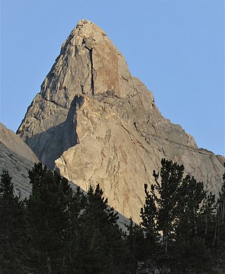
Pingora Peak is a prominent granite peak in the U.S. state of Wyoming. The peak is one of the pinnacles that forms the Cirque of the Towers. Pingora Peak is in the Popo Agie Wilderness and part of the Wind River Range within the greater Shoshone National Forest. The Northeast Face route on Pingora Peak is recognized in the historic climbing text Fifty Classic Climbs of North America and considered a classic around the world.
Three Waters Mountain is located in the northern Wind River Range in the U.S. state of Wyoming. Three Waters Mountain straddles the Continental Divide and is in both Bridger-Teton and Shoshone National Forests. The mountain receives its name from being the triple point between the watersheds of the Colorado, Columbia, and Mississippi Rivers.
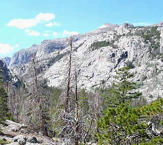
Downs Mountain is located in the Wind River Range in the U.S. state of Wyoming. Downs Mountain is the 15th highest peak in Wyoming. The summit is on the Continental Divide in both Shoshone and Bridger-Teton National Forests. The East Torrey Glacier is on the northern slopes of Downs Mountain, while Continental Glacier lies to the west and north and the Downs Glacier is 1 mi (1.6 km) to the south.
Torrey Peak is located in the northern Wind River Range in the U.S. state of Wyoming. Torrey Peak is in Shoshone National Forest near the southern end of Upper Ross Lake.
South Downs Mountain is located in the Wind River Range in the U.S. state of Wyoming. Downs Mountain is the 27th highest peak in Wyoming. The summit is on the Continental Divide in both Shoshone and Bridger-Teton National Forests and it is 1.85 mi (2.98 km) south-southwest of Downs Mountain.
Mount Lander is located in the central Wind River Range in the U.S. state of Wyoming. Mount Lander is within the Wind River Indian Reservation. The Lander Glacier consists of three distinct glaciers on the north and west slopes of Mount Lander, with the westernmost glacier being the largest. Baptiste Lake is 1 mi (1.6 km) long and is on the southeast base of Mount Lander and the famous northeast wall of Mount Hooker is another mile south of the lake.

Mount Washakie is located in the Wind River Range in the U.S. state of Wyoming. The mountain is on the Continental Divide in the Bridger Wilderness of Bridger-Teton National Forest and Popo Agie Wilderness of Shoshone National Forest. Washakie Glacier lies .50 mi (0.80 km) to the southeast of the peak.
Mount Chauvenet is a mountain located in the southern Wind River Range in the U.S. state of Wyoming. Mount Chauvenet is 1.5 mi (2.4 km) northeast of Cathedral Peak in the Popo Agie Wilderness of Shoshone National Forest. Mount Chauvenet was one of the earliest peaks climbed by white explorers to the Wind River Range.

Squaretop Mountain is an 11,695-foot-elevation (3,565-meter) mountain summit located in Sublette County of Wyoming, United States.

White Rock is a cliff with an 11,284-foot-elevation (3,439-meter) summit located in Sublette County of Wyoming, United States.

Haystack Mountain is an 11,978-foot-elevation (3,651-meter) mountain summit located in Sublette County of Wyoming, United States.
Steeple Peak is a 12,040-foot-elevation (3,670-meter) summit located in Sublette County of Wyoming, United States.

Spider Peak is a 12,234-foot-elevation (3,729-meter) mountain summit located in Fremont County of Wyoming, United States.

Mount Lester is a 12,342-foot-elevation (3,762-meter) mountain summit located in Sublette County, Wyoming, United States.

Bollinger Peak is a 12,232-foot-elevation (3,728-meter) mountain summit located on the shared border of Sublette County and Fremont County in the state of Wyoming, United States.

Hobbs Peak is an 11,663-foot-elevation (3,555-meter) mountain summit in Fremont County, Wyoming, United States.


