| Squaretop Mountain | |
|---|---|
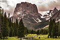
 Squaretop Mountain, northwest aspect | |
| Highest point | |
| Elevation | 11,695 ft (3,565 m) [1] |
| Prominence | 655 ft (200 m) [1] |
| Parent peak | Peak 11830 [2] |
| Isolation | 2.17 mi (3.49 km) [2] |
| Coordinates | 43°13′25″N109°47′27″W / 43.22361°N 109.79083°W [3] |
| Geography | |
 Squaretop Mountain Location in Wyoming  Squaretop Mountain Squaretop Mountain (the United States) | |
| Location | Sublette County, Wyoming, U.S. |
| Parent range | Wind River Range |
| Topo map | USGS Squaretop Mountain |
| Geology | |
| Rock type | Migmatite [4] |
| Climbing | |
| First ascent | < 1921 by William Stroud [1] |
| Easiest route | class 2 hiking [2] SE ledges |
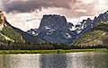
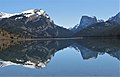
Squaretop Mountain is an 11,695-foot-elevation (3,565-meter) mountain summit located in Sublette County of Wyoming, United States. [3]