The mountain is composed of sedimentary rock that was laid down up to 450 million years ago in an ancient sea. The uppermost stratum is 300 million-year-old Madison Limestone, where seashell fossils are common. The cliff-forming limestone overlays a broken band of Darby Formation, which in turn overlays cliff-forming Bighorn Dolomite.[2] The once sea-level strata were uplifted during the Laramide orogeny. Obsidian chippings have been found near the summit, suggesting the first ascent was possibly made by Native Americans.[5]
Climate
According to the Köppen climate classification system, White Rock is located in an alpine subarctic climate zone with long, cold, snowy winters, and cool to warm summers.[6] Due to its altitude, it receives precipitation all year, as snow in winter, and as thunderstorms in summer. Precipitation runoff from the mountain drains into the Green River.
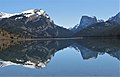
White Rock (left), Squaretop Mountain (right) reflected in Green River Lakes. White Rock is a dolomite and limestone cliff that rises 3,300 feet above the lake.
White Rock left of center
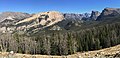
from Green River Lakes with White Rock on left, Squaretop in center, "Tabletop" on right
↑ Joe Kelsey, 2013, Climbing and Hiking in the Wind River Mountains, Falcon Guides, ISBN9781493001354, page 419.
↑ Peel, M. C.; Finlayson, B. L.; McMahon, T. A. (2007). "Updated world map of the Köppen−Geiger climate classification". Hydrol. Earth Syst. Sci. 11. ISSN1027-5606.
This page is based on this Wikipedia article Text is available under the CC BY-SA 4.0 license; additional terms may apply. Images, videos and audio are available under their respective licenses.