Mount Jumbo

Last updated
Mount Jumbo
Mount Jumbo in Missoula.jpg
Highest point
Elevation 4,768 ft (1,453 m) [1]
Prominence 808 ft (246 m) [1]
Coordinates 46°52′45″N113°57′23″W / 46.87917°N 113.95639°W / 46.87917; -113.95639 Coordinates: 46°52′45″N113°57′23″W / 46.87917°N 113.95639°W / 46.87917; -113.95639 [2]
Geography
Parent range Rattlesnake Mountains, Rocky Mountain Front [3]
Topo map USGS Northeast Missoula
Climbing
Easiest route Hike via old logging roads

Mount Jumbo (Salish: Sin Min Koos, meaning "obstacle" or "thing in the way"), [4] also called Mount Loyola by some locals, is a mountain that overlooks the city of Missoula in the U.S. state of Montana. The mountain is northeast of the city's downtown and, in its majority, is publicly owned. In 1996, Jumbo was purchased from private landowners and protected from development. Funding for this purchase came from an open space bond, federal and non-profit agencies and thousands of local contributors. Additional land parcels have been purchased since then, increasing the easement to 1,800 acres (730 ha).

Contents

Natural History

Glacial Lake Missoula

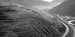
Between 15,000 and 13,000 years ago, Glacial Lake Missoula formed when an ice sheet blocked the Clark Fork River, damming up the river's water back into the valleys of western Montana. [5] The dam would periodically burst causing a flood of water to rush across Idaho, Washington and Oregon to the Pacific Ocean. This lake contained about 2,100 cubic kilometres (500 cu mi) of water, half the volume of Lake Michigan. [6] These dramatic drops in water levels caused the distinct glacial lake shoreline marks that are still visible from the floor of the Missoula Valley on the face of Mount Jumbo and neighboring Mount Sentinel. [7]

Wave-cut strandlines cut into the slope at left in photo. These cuts record former high-water lines, or shorelines. Gullies above the highway are the result of modern-day erosion. (NPS Photo) Orillas fosiles del lago Missoula.jpg
Wave-cut strandlines cut into the slope at left in photo. These cuts record former high-water lines, or shorelines. Gullies above the highway are the result of modern-day erosion. (NPS Photo)

Naming

David Thompson, an English-Canadian fur trader, ignoring the Salish name already given, renamed the hill 'Brown Knowl' when he climbed in on February 26, 1812. Later, eastern settlers thought Mount Jumbo looked like a sleeping elephant. Locals saw the landform as a reclining elephant with its rump in the Clark Fork and its trunk pointing north toward the Rattlesnake Mountains; the round grassy mountain became known as 'Elephant Hill.' Miners christened a nearby copper mine 'Jumbo Lode' in honor of Barnum and Bailey's most famous attraction Jumbo, the largest elephant in the world, which Barnum acquired in 1882. The feature was later renamed Mount Jumbo.

In the 19th Century, Jesuit priests that settled in the Missoula Valley referred to the mountain as Mount Loyola after St. Ignatius of Loyola. The Roman Catholic school named Loyola Sacred Heart, founded by Jesuit priests, was then opened in Missoula in 1873.

Protecting Mount Jumbo

In 1995, Missoula citizens approved a $5 million bond to preserve open, natural areas in the county. A year later, $2 million from that bond and another $1.5 million raised by Montana Fish, Wildlife and Parks, the U.S. Forest Service, Five Valleys Land Trust, the Rocky Mountain Elk Foundation and local residents was used to purchase the majority of the mountain. This initial portion included 1,465 acres. Since then, additional land purchases have opened a total of 1,800 acres across Mount Jumbo to public access as well as wildlife preservation.

The primary reason for protecting Mount Jumbo in 1996 was that a dense subdivision had been approved for the mountain's saddle.

Mount Jumbo's saddle is identified as an essential winter-feeding habitat for elk herds. Of the elk herds living near Missoula the herd on Jumbo is considered the most restricted in its movements.

Most parts of the mountain are closed during the winter to protect the elk that are under more stress at this time of year due to harsh weather and decreased food availability. The northern portion of Mount Jumbo is closed Dec. 1 until May 1, while the southern part is closed Dec. 1 to March 15. [8]

A stabilization in Jumbo's herd size has been observed since the winter closures began in 1997. [9]

Invasive weeds such as spotted knapweed, leafy spurge, cheatgrass, sulfur cinquefoil, Dyer's Woad and Dalmatian toadflax are established across Mount Jumbo. Numerous management programs are working to combat the invasive species spread. A non-profit organization called Working Dogs, has trained dogs to detect Dyer's Woad. After 10 years of detection work the number of this invasive plant has dropped from thousands to only 7 plants per year. Community weed-pulls organized by Missoula City as well as student, conservation and other private groups work to remove thousands of pounds of weeds from the mountain's face every year. Sheep have also been used as a management tool to graze on the unwanted species, although their efficacy is doubtful. [10]

Satellite view of Earth's mountain ranges. Earthmap1000x500.jpg
Satellite view of Earth's mountain ranges.

Recreation

Hiking

Mountain Biking

Flora and Fauna

Fauna of interest seen on Mount Jumbo include: whitetail deer, mule deer, black bear, elk, mountain lions, red fox, swallowtail butterflies, Blue Grouse, Lazuli Buntings, blue birds and falcons. Flora highlights include: service berry, hawthorn, ninebark, bluebunch wheatgrass, Ponderosa pine and Douglas fir. [12] Evidence of pine beetle infestation in conifers has been observed on Mount Jumbo. [13]

Related Research Articles

<span class="mw-page-title-main">Missoula County, Montana</span> County in Montana, United States

Missoula County is located in the State of Montana. As of the 2020 census, the population was 117,922, making it Montana's third-most populous county. Its county seat and largest city is Missoula. The county was founded in 1860.

<span class="mw-page-title-main">Flathead County, Montana</span> County in Montana, United States

Flathead County is in the U.S. state of Montana. At the 2020 census, its population was 104,357, making it the state's fourth most populous county. Its county seat is Kalispell. Its numerical designation is 7. Its northern border is on the state's north border, making it contiguous with the Canada–US border, facing British Columbia.

<span class="mw-page-title-main">Missoula, Montana</span> City in Montana, United States

Missoula is a city in the U.S. state of Montana; it is the county seat of Missoula County. It is located along the Clark Fork River near its confluence with the Bitterroot and Blackfoot Rivers in western Montana and at the convergence of five mountain ranges, thus it is often described as the "hub of five valleys". The 2020 United States Census shows the city's population at 73,489 and the population of the Missoula Metropolitan Area at 117,922. After Billings, Missoula is the second-largest city and metropolitan area in Montana. Missoula is home to the University of Montana, a public research university.

<span class="mw-page-title-main">Missoula floods</span> Heavy floods of the last ice age

The Missoula floods were cataclysmic glacial lake outburst floods that swept periodically across eastern Washington and down the Columbia River Gorge at the end of the last ice age. These floods were the result of periodic sudden ruptures of the ice dam on the Clark Fork River that created Glacial Lake Missoula. After each ice dam rupture, the waters of the lake would rush down the Clark Fork and the Columbia River, flooding much of eastern Washington and the Willamette Valley in western Oregon. After the lake drained, the ice would reform, creating Glacial Lake Missoula again.

<span class="mw-page-title-main">Glacial Lake Missoula</span> Prehistoric proglacial lake in Western Montana

Lake Missoula was a prehistoric proglacial lake in western Montana that existed periodically at the end of the last ice age between 15,000 and 13,000 years ago. The lake measured about 7,770 square kilometres (3,000 sq mi) and contained about 2,100 cubic kilometres (500 cu mi) of water, half the volume of Lake Michigan.

<span class="mw-page-title-main">Flathead Indian Reservation</span> Indian reservation in United States, Confederated Salish and Kootenai

The Flathead Indian Reservation, located in western Montana on the Flathead River, is home to the Bitterroot Salish, Kootenai, and Pend d'Oreilles tribes – also known as the Confederated Salish and Kootenai Tribes of the Flathead Nation. The reservation was created through the July 16, 1855, Treaty of Hellgate.

<span class="mw-page-title-main">Lolo Pass (Idaho–Montana)</span> United States historic place

Lolo Pass, elevation 5,233 feet (1,595 m), is a mountain pass in the western United States, in the Bitterroot Range of the northern Rocky Mountains. It is on the border between the states of Montana and Idaho, approximately forty miles (65 km) west-southwest of Missoula, Montana.

<span class="mw-page-title-main">Confederated Salish and Kootenai Tribes</span> Indigenous tribe in Montana, United States

The Confederated Salish and Kootenai Tribes of the Flathead Reservation are a federally recognized tribe in the U.S. state of Montana. The government includes members of several Bitterroot Salish, Kootenai and Pend d'Oreilles tribes and is centered on the Flathead Indian Reservation.

<span class="mw-page-title-main">Flathead Lake</span> Lake in Montana, United States

Flathead Lake is a large natural lake in northwest Montana.

<span class="mw-page-title-main">Dry Falls</span> Scalloped precipice with four major alcoves, in central Washington scablands

Dry Falls is a 3.5-mile-long (5.6 km) scalloped precipice with four major alcoves, in central Washington scablands. This cataract complex is on the opposite side of the Upper Grand Coulee from the Columbia River, and at the head of the Lower Grand Coulee, northern end of Lenore Canyon. According to the current geological model, catastrophic flooding channeled water at 65 miles per hour through the Upper Grand Coulee and over this 400-foot (120 m) rock face at the end of the last glaciation. It is estimated that the falls were five times the width of Niagara Falls, with ten times the flow of all the current rivers in the world combined.

<span class="mw-page-title-main">Bow Valley Provincial Park</span> Provincial park in Alberta, Canada

Bow Valley Provincial Park is a provincial park in Alberta, Canada. Established in 1959 in the arch of the Bow River at its confluence with the Kananaskis River, the park is one park of many within the Kananaskis Country park system.

<span class="mw-page-title-main">Bison Range</span> Nature reserve for bison in western Montana

The Bison Range (BR) is a nature reserve on the Flathead Indian Reservation in western Montana established for the conservation of American bison. Formerly called the National Bison Range, the size of the bison herd at the BR is 350 adult bison and welcomes between 50-60 calves per year. Established as a National Wildlife Refuge in 1908, the BR consists of approximately 18,524 acres (7,496 ha) within the Montana valley and foothill grasslands. The management was transferred back to the Confederated Salish and Kootenai Tribes in 2022 from the U.S. Fish and Wildlife Service after more than a century of federal management and nearly two decades of negotiations.

Rattlesnake National Recreation Area is a United States national recreation area located 4 miles north of Missoula, Montana in the Rattlesnake Creek drainage area. It is administered by the Lolo National Forest and is adjacent to the Rattlesnake Wilderness. Both the recreation area and the wilderness area were established by the U.S. Congress on October 19, 1980.

<span class="mw-page-title-main">Lake Lewis</span> Body of water

Lake Lewis was a large transient lake in the Pacific Northwest region of North America, formed by periodic Missoula Floods along the Columbia River paleocourse between 21,000 and 16,000 years ago.

Hell Gate is a ghost town at the western end of the Missoula Valley in Missoula County, Montana, United States. The town was located on the banks of the Clark Fork River roughly five miles downstream from present-day Missoula near what is now Frenchtown.

<span class="mw-page-title-main">Mount Sentinel</span> Mountain in Montana, United States

Mount Sentinel, originally known as "Mount Woody," is a small mountain located immediately east of the University of Montana in Missoula, Montana. At a height of 1,958 feet and an elevation of 5,158 feet (1,572 m), Mount Sentinel also features the hillside letter "M", a large concrete structure 620 feet (189 m) up its western face.

<span class="mw-page-title-main">History of Missoula, Montana</span>

The history of Missoula, Montana begins as early as 12,000 years ago with the end of the region's glacial lake period with western exploration dating back to the Lewis and Clark Expedition of 1804–1806. The first permanent settlement was founded in 1860.

<span class="mw-page-title-main">Rattlesnake Mountains (Montana)</span>

The Rattlesnake Mountains are a prominent mountain range located just 4 miles north of Missoula, Montana, USA. The highest point in the range is McLeod Peak,. Much of the range is protected in the Rattlesnake Wilderness and Rattlesnake National Recreation Area on the Lolo National Forest. An additional 36,000 acres (15,000 ha) of the range are protected on the Flathead Indian Reservation as the South Fork Tribal Primitive Area; this area is off-limits to non-tribal members. Including the Tribal Primitive Area, then, about 100,000 acres (40,000 ha) of the Rattlesnakes are roadless.

<span class="mw-page-title-main">Badger Mountain (Benton County, Washington)</span> Mountain in Washington (state), United States

Badger Mountain is a small mountain in Richland, Washington. Badger rises above the Tri-Cities connected to the smaller Candy Mountain via Goose Gap, is visible throughout much of the area and is a popular hiking destination for a wide variety of climbers. There are a number of trails climbing the mountain with varying levels of difficulty. Most of Badger Mountain is protected by the Badger Mountain Centennial Preserve, but the radio towers at the peak are private property. There are two summits on Badger Mountain, named the East Summit and the West Summit. The West Summit is the highest.

<span class="mw-page-title-main">U.S. Route 93 in Montana</span> Highway in Montana

U.S. Highway 93 is a north–south United States Numbered Highway in the state of Montana.

References

  1. 1 2 "Mount Jumbo". Peakbagger.com. Retrieved 2011-01-08.
  2. "Mount Jumbo". Geographic Names Information System . United States Geological Survey, United States Department of the Interior . Retrieved 2011-01-08.
  3. Mountain Ranges of Montana
  4. "Mount Jumbo in the Missoula valley". mountjumbo.org. Retrieved 2011-01-08.
  5. "Glacial Lake Missoula"
  6. Bjornstad, Bruce N. (c. 2006). On the trail of the Ice Age floods : a geological field guide to the mid-Columbia basin / Bruce Bjornstad. Sandpoint, Idaho: Keokee Books. p. 4. ISBN   978-1-879628-27-4.
  7. "Glacial Lake Missoula's shoreline"
  8. "Winter Closures Press Release 2010"
  9. "Elk Herds Around Missoula"
  10. “Mt. Jumbo Advisory Board minutes April 22, 2009”
  11. "Trails.com An Outdoorman's Guide"
  12. "Plants and animals on the hike"
  13. "Chaney, Rob. "Jumbo shows sign of beetle infestation". The Missoulian, November 4, 2009"