
Aoraki / Mount Cook is the highest mountain in New Zealand. Its height, as of 2014, is listed as 3,724 metres. It sits in the Southern Alps, the mountain range that runs the length of the South Island. A popular tourist destination, it is also a favourite challenge for mountain climbers. Aoraki / Mount Cook consists of three summits: from south to north, the Low Peak, the Middle Peak and the High Peak. The summits lie slightly south and east of the main divide of the Southern Alps, with the Tasman Glacier to the east and the Hooker Glacier to the southwest. Mount Cook is ranked 10th in the world by topographic isolation.
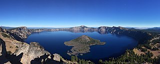
Crater Lake National Park is a national park of the United States located in southern Oregon. Established in 1902, Crater Lake is the fifth-oldest national park in the United States and the only national park in Oregon. The park encompasses the caldera of Crater Lake, a remnant of Mount Mazama, a destroyed volcano, and the surrounding hills and forests.

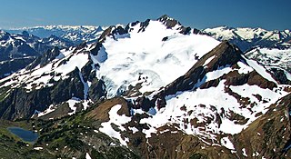
Mount Robson is the most prominent mountain in North America's Rocky Mountain range; it is also the highest point in the Canadian Rockies. The mountain is located entirely within Mount Robson Provincial Park of British Columbia, and is part of the Rainbow Range. Mount Robson is the second highest peak entirely in British Columbia, behind Mount Waddington in the Coast Range. The south face of Mount Robson is clearly visible from the Yellowhead Highway, and is commonly photographed along this route.

Mount McLoughlin is a dormant steep-sided stratovolcano, or composite volcano, in the Cascade Range of southern Oregon and within the United States Sky Lakes Wilderness. It is one of the volcanic peaks in the Cascade Volcanic Arc, within the High Cascades sector. A prominent landmark for the Rogue River Valley, the mountain is north of Mount Shasta, and south-southwest of Crater Lake. It was named around 1838 after John McLoughlin, a Chief Factor for the Hudson's Bay Company. Mount McLouglin's prominence has made it a landmark to Native American populations for thousands of years.

Mount Marcy is the highest point in the U.S. state of New York, with an elevation of 5,343.1 feet (1,628.6 m). It is located in the town of Keene in Essex County. The mountain is in the heart of the High Peaks Wilderness Area in Adirondack Park. Like the surrounding Adirondack Mountains, Marcy was heavily affected by large glaciers during recent ice ages, which deposited boulders on the mountain slopes and carved valleys and depressions on the mountain. One such depression is today filled by Lake Tear of the Clouds, which is often cited as the highest source of the Hudson River. The majority of the mountain is covered by hardwood and spruce-fir forests, although the highest few hundred feet are above the tree line. The peak is dominated by rocky outcrops, lichens, and alpine plants. The mountain supports a diverse number of woodland mammals and birds.

Mount Nebo is the southernmost and highest mountain in the Wasatch Range of Utah, in the United States, and the centerpiece of the Mount Nebo Wilderness, inside the Uinta National Forest. It is named after the biblical Mount Nebo in Jordan, overlooking Israel from the east of the Jordan River, which is said to be the place of Moses' death.

Mount Morrison is located in the Sierra Nevada, in the Sherwin Range. It rises south of Convict Lake near the town of Mammoth Lakes.

Mount Skylight is a mountain in the Adirondacks in the U.S. state of New York. Skylight is the fourth highest peak in New York, with an elevation of 4,924 feet (1,501 m), and one of the 46 High Peaks in Adirondack Park. It is located in the town of Keene in Essex County. The mountain was given its name by artist Frederick S. Perkins and guide Orson Schofield Phelps in 1857, due to a rock formation on the peak resembling a window. Phelps would later make the first known ascent of the peak with surveyor Verplanck Colvin and two others on August 28, 1873.

Mount Jiuhua located in Chizhou, Anhui Province in China is an important Buddhist site and natural scenic spot. It is one of the four famous Buddhist mountains in China, one of the first batch of 5A level scenic spots in China, one of the first batch of natural and cultural heritage sites in China, and the main scenic spot of "two mountains and one lake" tourism development strategy in Anhui Province. The planned area of the scenic spot is 120 square kilometers, and the protected area is 174 square kilometers, which is composed of 11 scenic spots.

Mount Langley is a mountain located on the crest of the Sierra Nevada, on the boundary between Inyo and Tulare counties in eastern California, in the United States. To the east is the Owens Valley, and to the west is the Kern River Valley. It is the ninth-highest peak in the state and the seventh-highest in the Sierra. Mount Whitney, the highest peak in the contiguous United States, lies 4.8 miles (7.7 km) to the northwest. Mount Langley also has the distinction of being the southernmost fourteener in the United States.

Serratus Mountain is a jagged, ridge-like mountain between Mount Tantalus (North) and Lake Lovely Water (South). Like most other peaks in the Tantalus Range, it is composed of loose rock. Most routes here are scrambles. The mountain is a standard single-day destination from the Jim Haberl hut.

Wedge Mountain, 2,895 m (9,498 ft) prominence: 2,249 m (7,379 ft), often locally referred to as The Wedge or simply "Wedge", is the highest summit in the Garibaldi Ranges and therefore also Garibaldi Provincial Park, and is among the nearest of the many peaks visible from the Whistler Blackcomb Ski Area, lying north across the valley of Billygoat Pass from the Spearhead Range, which includes one of that resort's two flagship mountains, Blackcomb. It was named for its distinctive wedge shape by the Garibaldi Park Board in 1932 in preference to Mount Vancouver, which had been submitted earlier. It is part of an unnamed range forming the most northerly group of peaks in the Garibaldi Ranges, the other two most notable being Mount Weart, known as the Armchair because of its shape, and Mount Currie, which overlooks the First Nations Reserve of the same name and the neighbouring town of Pemberton. Wedge's very high prominence is defined by the divide between the Green and Cheakamus Rivers at a locality at the south end of Alta Lake known as Tokum Corners.

Mount Sheridan, elevation 10,313 feet (3,143 m), is a prominent mountain peak overlooking Heart Lake in the Red Mountains of Yellowstone National Park. The peak is named in honor of General Philip H. Sheridan, U.S. Army, one of the early protectors of the park.

First Peoples Mountain el. 10,551 feet (3,216 m) is a mountain peak in the Absaroka Range in Yellowstone National Park. The peak was formerly named for Lieutenant Gustavus Cheyney Doane, a U.S. Army cavalry officer who escorted the Washburn-Langford-Doane Expedition into Yellowstone in 1870. During that expedition, Doane and Nathaniel P. Langford ascended several peaks east of Yellowstone Lake. The name was changed to First Peoples Mountain in 2022.

Mount Harrison, at 9,265 feet (2,824 m) is a peak in the northern Albion Mountains of Cassia County in southern Idaho. Mount Harrison is located in north of Cache Peak, south of Burley, northeast of Oakley, and west of Malta in the Albion Division of the Minidoka Ranger District of Sawtooth National Forest. Mount Harrison is in the watershed of tributaries of the Snake River, which itself is a tributary of the Columbia River. The peak can be reached via a paved road that runs all the way to its summit. Lake Cleveland is located in the basin north of the peak, and a small unnamed lake is located in the basin southeast of the peak.

Mount Sniktau is a high mountain summit in the Front Range of the Rocky Mountains of North America. The 13,240-foot (4,036 m) thirteener is located in Arapaho National Forest, 1.6 miles (2.5 km) northeast of Loveland Pass in Clear Creek County, Colorado, United States.
Cayoosh Mountain is a 2,561-metre (8,402-foot) mountain summit located in the Cayoosh Range in southwestern British Columbia, Canada. It is situated 22 km (14 mi) east-northeast of Pemberton, 12 km (7 mi) north-northeast of Lillooet Lake, and immediately north of Cayoosh Pass. Its nearest higher peak is Mount Marriott, 5.43 km (3 mi) to the north-northeast. Precipitation runoff from the peak drains into Cayoosh Creek and other tributaries of the Fraser River. The mountain's name was submitted by Karl Ricker, a mountaineer, and was officially adopted on January 23, 1979, by the Geographical Names Board of Canada.
Mount Spetch is a 2,579-metre (8,461-foot) mountain summit located in the Coast Mountains, in Joffre Lakes Provincial Park, in southwestern British Columbia, Canada. It is part of the Joffre Group, which is a subset of the Lillooet Ranges. It is situated 25 km (16 mi) east of Pemberton, midway between Mount Matier and Slalok Mountain, both one kilometre either side of Spetch. The mountain's name was submitted by Karl Ricker of the Alpine Club of Canada to honor Samuel W. Spetch, who operated the general store at Birken, and other businesses in Pemberton. The name was officially adopted on January 23, 1979, by the Geographical Names Board of Canada. The first ascent of the mountain was made in 1971 by J. Oswald and G. Walter. Precipitation runoff from the peak drains into Joffre Creek and Twin One Creek, both tributaries of the Lillooet River. The mountain and its climate supports the Matier Glacier on the northern slope.

Mount Chief Pascall is a 2,206-metre (7,238-foot) mountain summit located in the Joffre Group of the Lillooet Ranges, in southwestern British Columbia, Canada. It is situated 26 km (16 mi) east of Pemberton, 8 km (5 mi) southwest of Duffy Lake, and within Nlháxten/Cerise Creek Conservancy. Cayoosh Pass lies immediately northwest of the mountain, with Cayoosh Mountain on the opposite side of the pass. Its nearest higher peak is Joffre Peak, 2.1 km (1 mi) to the south, and Mount Rohr rises 5 km (3 mi) to the northeast. Precipitation runoff from the peak drains into tributaries of Cayoosh Creek.

