
Mount Forbes is the seventh tallest mountain in the Canadian Rockies and the tallest within the boundaries of Banff National Park. It is located in southwestern Alberta, 18 km (11 mi) southwest of the Saskatchewan River Crossing in Banff. The mountain was named by James Hector in 1859 after Edward Forbes, Hector's natural history professor at the University of Edinburgh during the mid-19th century.

The Western Interior Seaway was a large inland sea that split the continent of North America into two landmasses for 34 million years. The ancient sea, which existed from the early Late Cretaceous to the earliest Paleocene, connected the Gulf of Mexico to the Arctic Ocean. The two land masses it created were Laramidia to the west and Appalachia to the east. At its largest extent, it was 2,500 feet (760 m) deep, 600 miles (970 km) wide and over 2,000 miles (3,200 km) long.
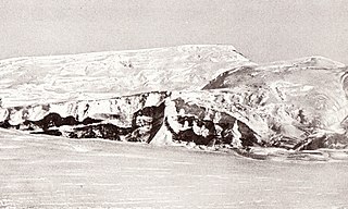
Mount Nansen is a prominent mountain, surmounting the steep eastern escarpment of the Eisenhower Range, 17 km (11 mi) south of Mount Baxter, in Victoria Land. Discovered by the British National Antarctic Expedition (1901–04), and named for Fridtjof Nansen, Norwegian Arctic explorer from whom Capt. Scott obtained much practical information for his expedition.

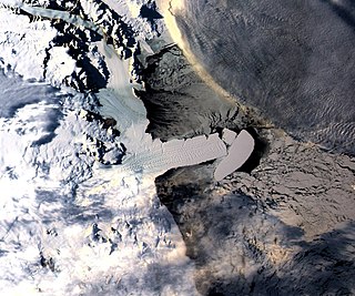
The Axel Heiberg Glacier in Antarctica is a valley glacier, 30 nautical miles long, descending from the high elevations of the Antarctic Plateau into the Ross Ice Shelf between the Herbert Range and Mount Don Pedro Christophersen in the Queen Maud Mountains.
The Herbert Range is a range in the Queen Maud Mountains of Antarctica, extending from the edge of the Antarctic Plateau to the Ross Ice Shelf between the Axel Heiberg Glacier and Strom Glacier. Named by the New Zealand Antarctic Place-Names Committee (NZ-APC) for Walter W. Herbert, leader of the Southern Party of the New Zealand GSAE (1961–62) which explored the Axel Heiberg Glacier area.
The Prince Albert Mountains are a major mountain group in Antarctica over 200 nautical miles long. Located in Victoria Land, they run north–south between the Priestley Glacier to the north and Ferrar Glacier to the south. They are south of the Deep Freeze Range and north of the Kirkwood Range.

Mount Cleveland is the highest mountain in Glacier National Park, located in Montana, United States. It is also the highest point in the Lewis Range, which spans part of the northern portion of the park and extends into Canada. It is located approximately 3 mi (4.8 km) southeast of the southern end of Waterton Lake, and approximately 5 mi (8.0 km) south of the US–Canada border. The east side of the future national park was purchased by the federal government from the Blackfoot Confederacy in 1895 during the second term of President Grover Cleveland. According to the United States Board on Geographic Names, the mountain is named for the former president.
The Lewis Overthrust is a geologic thrust fault structure of the Rocky Mountains found within the bordering national parks of Glacier in Montana, United States and Waterton Lakes in Alberta, Canada. The structure was created due to the collision of tectonic plates about 59-75 million years ago that drove a several mile thick wedge of Precambrian rock 50 mi (80 km) eastwards, causing it to overlie softer Cretaceous age rock that is 1300 to 1400 million years younger.

The Insular Mountains are a range of mountains in the Pacific Coast Ranges on the Coast of British Columbia, Canada, comprising the Vancouver Island Ranges and Queen Charlotte Mountains. The Insular Mountains are rugged, particularly on Vancouver Island where peaks in Strathcona Provincial Park rise to elevations of more than 2,000 m (6,562 ft). The highest of these mountains is Golden Hinde on Vancouver Island, which rises to 2,196.818 m (7,207 ft).

The geology of the Pacific Northwest includes the composition, structure, physical properties and the processes that shape the Pacific Northwest region of North America. The region is part of the Ring of Fire: the subduction of the Pacific and Farallon Plates under the North American Plate is responsible for many of the area's scenic features as well as some of its hazards, such as volcanoes, earthquakes, and landslides.
The High Arctic Large Igneous Province (HALIP) is a Cretaceous large igneous province in the Arctic. The region is divided into several smaller magmatic provinces. Svalbard, Franz Josef Land, Sverdrup Basin, Amerasian Basin, and northern Greenland are some of the larger divisions. Today, HALIP covers an area greater than 1,000,000 km2 (390,000 sq mi), making it one of the largest and most intense magmatic complexes on the planet. However, eroded volcanic sediments in sedimentary strata in Svalbard and Franz Josef Land suggest that an extremely large portion of HALIP volcanics have already been eroded away.

Liv Glacier is a steep valley glacier, 40 nautical miles long, emerging from the Antarctic Plateau just southeast of Barnum Peak and draining north through the Queen Maud Mountains to enter Ross Ice Shelf between Mayer Crags and Duncan Mountains. It was discovered in 1911 by Roald Amundsen, who named it for the daughter of Fridtjof Nansen.

The Coast Range Arc was a large volcanic arc system, extending from northern Washington through British Columbia and the Alaska Panhandle to southwestern Yukon. The Coast Range Arc lies along the western margin of the North American Plate in the Pacific Northwest of western North America. Although taking its name from the Coast Mountains, this term is a geologic grouping rather than a geographic one, and the Coast Range Arc extended south into the High Cascades of the Cascade Range, past the Fraser River which is the northward limit of the Cascade Range proper.

Mount Tantalus is a 2,608-metre (8,556-foot) mountain in southwestern British Columbia, Canada, located 24 km (15 mi) southeast of Falk Lake and 134 km (83 mi) south of Monmouth Mountain. It is the highest mountain in the Tantalus Range of the Pacific Ranges and is famous for its snow-covered face.
Mount Brew is a mountain located 12 km (7 mi) south of Lillooet and 44 km (27 mi) north of Skihist Mountain in south-central British Columbia, Canada. It lies on the western side of the Fraser River and is the third-highest mountain of the Lillooet Ranges, after Skihist Mountain and Petlushkwohap Mountain in the Cantilever Range to the west of Lytton.
Nansen Ice Sheet is a 30 nautical miles long by 10 nautical miles wide ice shelf. It is nourished by the Priestley and Reeves Glaciers and abuts the north side of the Drygalski Ice Tongue, along the coast of Victoria Land, Antarctica. This feature was explored by the South Magnetic Polar Party of the British Antarctic Expedition, 1907-09 and by the Northern Party of the British Antarctic Expedition, 1910-13. Frank Debenham, geologist with the latter expedition, applied the name Nansen Sheet as the feature is adjacent to Mount Nansen, the dominating summit in the area.
The Reeves Glacier is a broad glacier originating on the interior upland and descending between Eisenhower Range and Mount Larsen to merge with the Nansen Ice Sheet along the coast of Victoria Land, Antarctica.

Mount Alderson is a 2,692-metre (8,832-foot) summit located in Waterton Lakes National Park, in the Canadian Rockies of Alberta, Canada. Its nearest higher peak is Mount Custer, 8.0 km (5.0 mi) to the southwest. Mount Richards is situated 2.0 km (1.2 mi) to the southeast, and Bertha Peak is to the immediate northeast.

Mount Dungarvan is a 2,575-metre (8,448-foot) mountain summit located in Waterton Lakes National Park, in the Canadian Rockies of Alberta, Canada. Its nearest higher peak is Cloudy Peak, 2.8 km (1.7 mi) to the west.

Mount Tecumseh is a 2,547-metre-high (8,356 ft) mountain summit located in the Canadian Rockies of Alberta, Canada.
