Mount Sherman, Kentucky | |
|---|---|
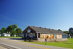 Post office and youth center | |
 Mount Sherman Location in Kentucky  Mount Sherman Location in the United States | |
| Coordinates: 37°27′09″N85°40′06″W / 37.45250°N 85.66833°W | |
| Country | United States |
| State | Kentucky |
| County | LaRue |
| Elevation | 912 ft (278 m) |
| Time zone | UTC-5 (Eastern (EST)) |
| • Summer (DST) | UTC-4 (EDT) |
| GNIS feature ID | 498863 [1] |
Mount Sherman is an unincorporated community located in LaRue County, Kentucky, United States. [2] The community is concentrated around the intersection of Kentucky Route 61 and Kentucky Route 1906, southeast of Hodgenville. The zip code is: 42764.
