Cerulean is a census-designated place and unincorporated community in Trigg and Christian counties, Kentucky, United States. At one time, it was a city, incorporated as Cerulean Springs. It lies along Kentucky Routes 124 and 126 northeast of the city of Cadiz, the county seat of Trigg County. Its elevation is 512 feet (156 m), and it is located at 36°57′34″N87°42′36″W. It has a post office with the ZIP code 42215.

Summersville is a census-designated place (CDP) and unincorporated community in Green County, Kentucky, United States. As of the 2010 census it had a population of 568.
Alpha is an unincorporated community in Clinton County, Kentucky, United States. It lies along Route 90 northeast of the city of Albany, the county seat of Clinton County. Its elevation is 1,014 feet (309 m), and it is located at 36°45′44″N85°0′37″W. It has a post office with the ZIP code 42603.

Marrowbone is a census-designated place in Cumberland County, Kentucky, United States. As of the 2010 census it had a population of 217. It has a post office, with the ZIP code of 42759.
Hazel Green is a census-designated place and unincorporated community in Wolfe County, Kentucky, United States. It lies along Routes 191 and 205 northeast of the city of Campton, the county seat of Wolfe County. Its elevation is 922 feet (281 m). It has a post office with the ZIP code 41332.
Ezel is an unincorporated community and census-designated place (CDP) in Morgan County, Kentucky, United States. As of the 2020 census, it had a population of 209. It has a small post office, with the ZIP code 41425.
Climbing Hill is an unincorporated community in Woodbury County, Iowa, United States. Its elevation is 1,135 feet (346 m). The community is part of the Sioux City, IA–NE–SD Metropolitan Statistical Area. It has a post office with the ZIP code 51015.

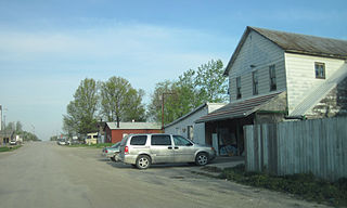
Falun is an unincorporated community in southwestern Saline County, Kansas, United States. As of the 2020 census, the population of the community and nearby areas was 83. It lies southwest of Salina and northwest of Lindsborg at the intersection of Forsse Road and Hedberg Road, about 7.5 miles west of Interstate 135 highway, or about 8 miles west of Assaria. It lies next to an abandoned railroad.

Peoa is an unincorporated census-designated place in southwestern Summit County, Utah, United States, between Jordanelle and Rockport State Parks. It lies along State Route 32, south of the city of Coalville, the county seat of Summit County. Its elevation is 6,191 feet (1,887 m). The population was 253 at the 2010 census. Peoa is unincorporated with the ZIP code of 84061.
Tridell is an unincorporated community in the Uinta Basin in western Uintah County, Utah, United States.

Veyo is a census-designated place in western Washington County, Utah, United States, on the edge of the Dixie National Forest. The population was 483 at the 2010 census. The town lies along State Route 18 north of the city of St. George.

Ames is an unincorporated hamlet in southern Dodge County, Nebraska, United States. As of the 2010 census it had a population of 24.

Neal is an unincorporated community in eastern Greenwood County, Kansas, United States. As of the 2020 census, the population of the community and nearby areas was 37. It is located approximately 10 miles east of the city of Eureka along U.S. Route 54 highway.
Chapin is an unincorporated community and census-designated place in northern Franklin County, Iowa, United States. It lies along local roads just off U.S. Route 65, north of the city of Hampton, the county seat of Franklin County. Its elevation is 1,155 feet (352 m), and it is located at 42°50′1″N93°13′20″W. Although Chapin is unincorporated, it has a post office with the ZIP code of 50427, which opened on 29 February 1860. As of the 2010 census, its population was 87.
Conroy is an unincorporated community and census-designated place (CDP) in central Iowa County, Iowa, United States. It lies along local roads southeast of the city of Marengo, the county seat of Iowa County. Its elevation is 879 feet (268 m). Conroy has a post office with the ZIP Code of 52220, which opened on 5 January 1885. As of the 2010 census the population was 259.
Argyle is an unincorporated community in southwestern Lee County, Iowa, United States. As of the 2020 census, its population was 91.

Boys Ranch is a census-designated place and unincorporated community in northeastern Oldham County, Texas, United States, on the site of the original county seat, Tascosa. It lies along U.S. Route 385, northeast of the city of Vega, the county seat of Oldham County. Although Boys Ranch is unincorporated, it has a post office, with the ZIP code of 79010. Boys Ranch is a residential community serving boys and girls ages 5 to 18. It was founded in 1939 by Cal Farley for troubled youth and is now a census-designated place. This was a new CDP for the 2010 census with a population of 282.
Carlsbad is a census-designated place and unincorporated community in northwest Tom Green County, Texas, United States. It lies along U.S. Route 87 northwest of the city of San Angelo, the county seat of Tom Green County. Its elevation is 2,024 feet (617 m). Although Carlsbad is unincorporated, it has a post office, with the ZIP code of 76934; the ZCTA for ZIP Code 76934 had a population of 1,332 at the 2000 census.
Cee Vee is an unincorporated community in northwestern Cottle County, Texas, United States. It lies along FM 1440 northwest of the town of Paducah, the county seat of Cottle County. Its elevation is 1,880 feet (573 m), and it is located at 34°13′23″N100°26′44″W. Although Cee Vee is unincorporated, it has a post office, with the ZIP code of 79223; the ZCTA for ZIP Code 79223 had a population of 35 at the 2000 census.
Wallace is a census-designated place and unincorporated community in northwestern Marlboro County, South Carolina, United States. It lies at the intersection of U.S. Route 1 with SC 9 and SC 177, northwest of the city of Bennettsville, the county seat of Marlboro County. Its elevation is 151&feet (46 m). Although Wallace is unincorporated, it has a post office, with the ZIP code of 29596; the ZCTA for ZIP code 29596 had a population of 2,606 at the 2000 census.


