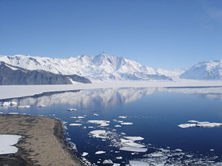
The Admiralty Mountains is a large group of high mountains and individually named ranges and ridges in northeastern Victoria Land, Antarctica. This mountain group is bounded by the sea, and by the Dennistoun Glacier, Ebbe Glacier, and Tucker Glacier.
The Wisconsin Range is a major mountain range of the Horlick Mountains in Antarctica, comprising the Wisconsin Plateau and numerous glaciers, ridges and peaks bounded by the Reedy Glacier, Shimizu Ice Stream, Horlick Ice Stream and the interior ice plateau.
The Neptune Range is a mountain range, 70 nautical miles long, lying west-southwest of Forrestal Range in the central part of the Pensacola Mountains, Antarctica. The range comprises Washington Escarpment with its associated ridges, valleys and peaks, the Iroquois Plateau, the Schmidt and the Williams Hills.

Joinville Island is the largest island of the Joinville Island group, about 40 nautical miles long in an east–west direction and 12 nautical miles wide, lying off the northeastern tip of the Antarctic Peninsula, from which it is separated by the Antarctic Sound.
The Support Force Glacier is a major glacier in the Pensacola Mountains, draining northward between the Forrestal Range and Argentina Range to the Filchner-Ronne Ice Shelf.
Lillie Glacier is a large glacier in Antarctica, about 100 nautical miles long and 10 nautical miles wide. It lies between the Bowers Mountains on the west and the Concord Mountains and Anare Mountains on the east, flowing to Ob' Bay on the coast and forming the Lillie Glacier Tongue.
The Merrick Mountains are a cluster of mountains, 8 nautical miles long, standing 7 nautical miles northeast of the Behrendt Mountains in Ellsworth Land, Antarctica.

The Prince Charles Mountains are a major group of mountains in Mac. Robertson Land in Antarctica, including the Athos Range, the Porthos Range, and the Aramis Range. The highest peak is Mount Menzies, with a height of 3,228 m (10,591 ft). Other prominent peaks are Mount Izabelle and Mount Stinear. These mountains, together with other scattered peaks, form an arc about 420 km (260 mi) long, extending from the vicinity of Mount Starlight in the north to Goodspeed Nunataks in the south.

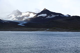
Saint Andrews Bay is a bight 2 miles (3.2 km) wide, indenting the north coast of South Georgia immediately south of Mount Skittle. Probably first sighted by the British expedition under Cook which explored the north coast of South Georgia in 1775. The name dates back to at least 1920 and is now well established. On charts where abbreviations are used, the name may be abbreviated to St. Andrews Bay.
Paget Glacier is a glacier in South Georgia, 4 miles (6 km) long and 1 mile (1.6 km) wide, which flows northeast from the north slopes of Mount Paget into the west side of Nordenskjold Glacier. The glacier was roughly surveyed in 1928–29 by a German expedition under Kohl-Larsen, and resurveyed in 1951–52 by the SGS. The name, which is derived from nearby Mount Paget, was given by the SGS in 1951–52.
Webb Glacier is a glacier, 2 miles (3.2 km) long, flowing southeast from Mount Brooker into Ross Glacier on the north side of South Georgia. Surveyed by the South Georgia Survey, 1954–55. Named for Edgar Clive Webb, member of the SGS who, with Ian.M. Brooker, climbed Mount Brooker on January 30, 1955. This glacier forms part of the approach route to the mountain.

The Scott Glacier is a major glacier, 120 nautical miles long, that drains the East Antarctic Ice Sheet through the Queen Maud Mountains to the Ross Ice Shelf. The Scott Glacier is one of a series of major glaciers flowing across the Transantarctic Mountains, with the Amundsen Glacier to the west and the Leverett and Reedy glaciers to the east.

Liv Glacier is a steep valley glacier, 40 nautical miles long, emerging from the Antarctic Plateau just southeast of Barnum Peak and draining north through the Queen Maud Mountains to enter Ross Ice Shelf between Mayer Crags and Duncan Mountains. It was discovered in 1911 by Roald Amundsen, who named it for the daughter of Fridtjof Nansen.
The Mountaineer Range is the range of mountains lying between the Mariner Glacier and Aviator Glacier in Victoria Land, Antarctica. It lies to the south of the Victory Mountains and northeast of the Southern Cross Mountains.
New Bedford Inlet is a large pouch-shaped, ice-filled embayment between Cape Kidson and Cape Brooks, along the east coast of Palmer Land, Antarctica.
The Porthos Range is the second range south in the Prince Charles Mountains of Antarctica, extending for about 30 miles in an east-to-west direction between Scylla Glacier and Charybdis Glacier. First visited in December 1956 by the Australian National Antarctic Research Expeditions (ANARE) southern party under W.G. Bewsher (1956-57) and named after Porthos, a character in Alexandre Dumas, père's novel The Three Musketeers, the most popular book read on the southern journey.
Watson Escarpment is a major escarpment in the Queen Maud Mountains, trending northward along the east margin of Scott Glacier, then eastward to Reedy Glacier where it turns southward along the glacier's west side. Somewhat arcuate, the escarpment is nearly 100 nautical miles long, rises 3,550 metres (11,650 ft) above sea level, and 1,000 to 1,500 metres above the adjacent terrain.
Fusilier Mountain is a mountain rising to 810 metres (2,660 ft) on the north side of Heaney Glacier, 2.7 nautical miles (5 km) west of Mount Skittle, on the north coast of South Georgia. The field name "Dome Mountain" was used by the South Georgia Survey, 1951–52. It was named by the UK Antarctic Place-Names Committee in 1991 after the Royal Regiment of Fusiliers, established in 1688, one of the oldest Regiments in the British Army. A detachment of the 3rd Battalion RRF, commanded by Captain PMD Harris RRF was stationed at Grytviken in the austral winter of 1988.
Schimper Glacier is a glacier in the east part of Herbert Mountains, Shackleton Range, flowing north-northeast into Slessor Glacier.
Luisa Bay is a small bay lying between Cape Vakop and Mount Skittle on the north coast of South Georgia. It was surveyed by the South Georgia Survey, 1951–52, and named by the UK Antarctic Place-Names Committee for the Luisa, one of the vessels of the Compañía Argentina de Pesca which participated in establishing the first permanent whaling station at Grytviken, South Georgia, in 1904. The vessel is now a hulk lying in King Edward Cove.
![]() This article incorporates public domain material from "Mount Skittle". Geographic Names Information System . United States Geological Survey.
This article incorporates public domain material from "Mount Skittle". Geographic Names Information System . United States Geological Survey. 


