
Mount Vernon is a city in and the county seat of Jefferson County, Illinois, United States. The population was 14,600 at the 2020 census. Mount Vernon is the principal city of the Mount Vernon Micropolitan Statistical Area, which includes all of Jefferson and Hamilton counties.
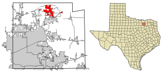
Anna is a city in the U.S. state of Texas. Located in Collin County, its population was 16,896 at the 2020 U.S. census.

Fulshear is a city in northwest Fort Bend County, Texas, United States, and is located on the western edge of the Houston–The Woodlands–Sugar Land metropolitan area. The population was 16,856 as of the 2020 census.

Mount Vernon is a town and the county seat of Franklin County, Texas, United States. The population was 2,491 at the 2020 United States census.

Washington-on-the-Brazos is an unincorporated community along the Brazos River in Washington County, Texas, United States. The town is best known for being the site of the Convention of 1836 and the signing of the Texas Declaration of Independence.

The Fifth Ward is a community of Houston, Texas, United States, derived from a historical political district (ward), about 2 miles (3.2 km) northeast of Downtown. Its boundaries are Buffalo Bayou on the south, Jensen Drive on the west, Liberty Road on the north, and Lockwood Drive on the east.

Mount Olivet Cemetery is a 206-acre (83 ha) cemetery located in Nashville, Tennessee. It is located approximately two miles East of downtown Nashville, and adjacent to the Catholic Calvary Cemetery. It is open to the public during daylight hours.
Alief is a working-class neighborhood in Southwest Harris County, Texas, United States. Most of Alief is within the city limits of Houston, while a portion of the community is in unincorporated Harris County.
Cooper is a small unincorporated community located in southwestern Houston County, Texas, United States. According to the Handbook of Texas, the community had a population of 27 in 2000.
America's 11 Most Endangered Places or America's 11 Most Endangered Historic Places is a list of places in the United States that the National Trust for Historic Preservation considers the most endangered. It aims to inspire Americans to preserve examples of architectural and cultural heritage that could be "relegated to the dustbins of history" without intervention.
Hopewell is an unincorporated community in Franklin County, Texas, United States. According to the Handbook of Texas, the community had a population of 35 in 2000.
Dry Creek is a rural unincorporated community in the east-central portion of Beauregard Parish, Louisiana, United States. It lies 20 miles (32 km) southeast of DeRidder on the corner of Louisiana highways 113 and 394. Dry Creek is 104 feet (32 m) above sea level.
Clearwater is an unincorporated community in Franklin County, Texas, United States.
Hagansport is an unincorporated community in Franklin County, Texas, United States. According to the Handbook of Texas, the community had a population of 40 in 2000.
Avon, Washington is an unincorporated community in Skagit County, Washington, along the Skagit River. Its neighboring towns include Mount Vernon and Burlington. Local historians have speculated that Avon is named after Stratford-upon-Avon.
Porter Springs, also known as Porter's Springs, is an unincorporated community in Houston County, Texas, United States. According to the Handbook of Texas, the community had a population of 50 in 2000.
Germany is an unincorporated community in Houston County, Texas, United States. According to the Handbook of Texas, the community had a population of 43 in 2000.
Cypress is an unincorporated community in Franklin County, in the U.S. state of Texas. According to the Handbook of Texas, the community had a population of 20 in 2000.
Eureka is an unincorporated community in Franklin County, Texas, United States. According to the Handbook of Texas, the community had a population of 18 in 2000.
Macon is an unincorporated community in Franklin County, Texas, United States.


