The District of Highlands is a district municipality near Victoria, British Columbia, Canada. As one of the Western Communities, or West Shore municipalities, outside Victoria, Highlands has a population of 2,225 as of 2016. The region stretches along the Saanich Inlet shoreline from north of Goldstream to Mackenzie Bight. Highlands is one of the more undeveloped areas of the Greater Victoria region; it is one of the newest Greater Victoria municipalities created within the Capital Regional District.

British Columbia is the westernmost province of Canada, bordered by the Pacific Ocean. With an area of 944,735 km2 (364,764 sq mi) it is Canada's third-largest province. The province is almost four times the size of the United Kingdom and larger than every United States state except Alaska. It is bounded on the northwest by the U.S. state of Alaska, directly north by Yukon and the Northwest Territories, on the east by Alberta, and on the south by the U.S. states of Washington, Idaho, and Montana. Formerly part of the British Empire, the southern border of British Columbia was established by the 1846 Oregon Treaty. The province is dominated by mountain ranges, among them the Canadian Rockies but dominantly the Coast Mountains, Cassiar Mountains, and the Columbia Mountains. Most of the population is concentrated on the Pacific coast, notably in the area of Vancouver, located on the southwestern tip of the mainland, which is known as the Lower Mainland. It is the most mountainous province of Canada.

The North Shore Mountains are a mountain range overlooking Vancouver in British Columbia, Canada. Their southernmost peaks are visible from most areas in Vancouver and form a distinctive backdrop for the city.

Tŝ’ilʔoŝ, also known as Mount Tatlow, is one of the principal summits of the Chilcotin Ranges subdivision of the Pacific Ranges of the Coast Mountains of southern British Columbia. Standing on an isolated ridge between the lower end of Chilko Lake and the Taseko Lakes, it is 3,063 m (10,049 ft) in elevation.

Gowlland Tod Provincial Park is a provincial park in British Columbia, Canada. The park protects 1,219 hectares of mixed forest of Douglas-fir, Arbutus, western redcedar, western hemlock, shore pine, grand fir, red alder, and Garry oak within the District Municipality of Highlands and the Juan de Fuca Electoral Area. Rocky outcroppings support Manzanita, Scotch broom, and Oregon grape. The peaks of the Gowlland Range, from which the park derives its name, loom over 400 m (1,300 ft) above Saanich Inlet, providing vistas of The Malahat to the west. Farther north, the park curves around inland, bounded to the north by the municipality of Central Saanich. The park also encompasses the rural community of Willis Point. There are 25 km (16 mi) of maintained trails within the park, accessible in the south from roads leading to the park from Highlands, as well as from trails alongside Tod Inlet and McKenzie Bight to the north. Trails connect to Mount Work Regional Park and Lone Tree Hill Regional Park.

Kakwa Provincial Park and Protected Area is a 170,890 ha provincial park in northeastern British Columbia, Canada. The park preserves the southernmost portion of the Hart Ranges and the northernmost portion of the Continental Ranges. The park also preserves significant marine fossil deposits located in the region.
Mount Geoffrey Escarpment Provincial Park is a Class-A provincial park in British Columbia, Canada, located on the southwest coast of Hornby Island. It covers an area of 187 hectares, stretching from the Shingle Spit ferry landing in the west to Ford Cove in the east.
Saanich Peninsula is located north of Victoria, British Columbia, Canada. It is bounded by Saanich Inlet on the west, Satellite Channel on the north, the small Colburne Passage on the northeast, and Haro Strait on the east. The exact southern boundary of what is referred to as the "Saanich Peninsula" is somewhat fluid in local parlance.

Tantalus Provincial Park is a provincial park located in the Tantalus Range overlooking Squamish Valley in British Columbia, Canada. It was established on December 19, 1998 to protect a large area of pristine alpine wilderness.

The Hart Ranges are a major subrange of the Canadian Rockies located in northeastern British Columbia and western Alberta. The mountains constitute the southernmost portion of the Northern Rocky Mountains.

The Vancouver Island Ranges, formerly called the Vancouver Island Mountains, are a series of mountain ranges extending along the length of Vancouver Island which has an area of 31,788 km2 (12,273 sq mi). The Vancouver Island Ranges comprise the central and largest part of the island. The Geological Survey of Canada refers to Vancouver Island, Haida Gwaii, and the Alaska Panhandle as the Insular Belt including the sea floor out to 100 km (62 mi) west of Vancouver Island. The Vancouver Island Ranges are a sub-range of the Insular Mountains.
The Insular Mountains are a range of mountains in the Pacific Coast Ranges on the Coast of British Columbia, Canada, comprising the Vancouver Island Ranges and Queen Charlotte Mountains. The Insular Mountains are rugged, particularly on Vancouver Island where peaks in Strathcona Provincial Park rise to elevations of more than 2,000 m (6,562 ft). The highest of these mountains is Golden Hinde on Vancouver Island, which rises to 2,196.818 m (7,207 ft).

The Fannin Range is a small mountain range in the Pacific Ranges of the Coast Mountains of British Columbia, Canada. Lying between the Seymour River and the glacial fjord Indian Arm, the range extends from the slopes of Mount Seymour on the Burrard Inlet to the district of North Vancouver more than 34 km (21 mi) north to the headwaters of the Indian River. It is named after the naturalist John Fannin It is commonly considered to be part of the North Shore Mountains.
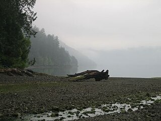
McKenzie Bight is a feature on the southeast side of Saanich Inlet in British Columbia, Canada. This bight is located in Gowlland Tod Provincial Park directly adjacent to the rural community of Willis Point. McKenzie Bight can be accessed by trail from the Mount Work parking area and trailhead on Ross-Durrance road, or via a short hike from the southern end of Mark Lane in Willis Point. Nearby is a reef which is a popular shore-dive location for scuba diving.
The Northern Rocky Mountains, usually referred to as the Northern Rockies, are a subdivision of the Canadian Rockies comprising the northern half of the Canadian segment of the Rocky Mountains. While their northward limit is easily defined as the Liard River, which is the northward terminus of the whole Rockies, the southward limit is debatable, although the area of Mount Ovington and Monkman Pass is mentioned in some sources, as south from there are the Continental Ranges, which are the main spine of the Rockies forming the boundary between British Columbia and Alberta. Some use the term to mean only the area north of the Peace Arm of the Williston Reservoir, and in reference to Northern Rocky Mountains Provincial Park, while others consider the term to extend all the way south, beyond the limit of the Hart Ranges at Mount Ovington, to include the McBride area, the Sir Alexander Group and Mount Robson.

The Gowlland Range is a low, small mountain range on southern Vancouver Island, British Columbia, Canada, located just east of Saanich Inlet and south of Brentwood Bay. It has an area of 58 km2 (22 sq mi) and is a subrange of the Vancouver Island Ranges which in turn form part of the Insular Mountains. The range's highest peak is Mt. Work.
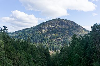
Mount Finlayson is a 419-metre (1,375 ft) mountain located on the border of Highlands and Langford, British Columbia, about 14 km northwest of Victoria.

Mount Arrowsmith Biosphere Region (MABR) is a UNESCO Biosphere Reserve located on the east coast of Vancouver Island in British Columbia, Canada. It was designated in 2000 by UNESCO to protect a large second-growth coast Douglas fir ecosystem in the watersheds of the Little Qualicum and Englishman Rivers from being developed.

The Sea to Sea Green Blue Belt is a 62 kilometre long greenbelt surrounding the Greater Victoria metropolitan area in Canada. The greenbelt includes green space, forests, farms, and wetlands stretching from Sooke to Salt Spring Island. It also includes the "blue spaces" of Sooke Basin and Saanich Inlet.

Willis Point is a small, rural community in the Canadian province of British Columbia, located in the Juan de Fuca Electoral Area within the Capital Regional District and Greater Victoria. It is located on the Saanich Peninsula and faces north toward the Saanich Inlet. The community is bounded by the District of Highlands to the south, the District of Saanich to the southeast and the District of Central Saanich to the east. It is located west of the village of Brentwood Bay and north of the city of Victoria.

