Glazovsky District is an administrative and municipal district (raion), one of the twenty-five in the Udmurt Republic, Russia. It is located in the north of the republic. The area of the district is 2,159.7 square kilometers (833.9 sq mi). Its administrative center is the city of Glazov. Population: 17,132 (2010 Census); 18,792 ; 19,161 (1989 Census).

Grakhovsky District is an administrative and municipal district (raion), one of the twenty-five in the Udmurt Republic, Russia. It is located in the southwest of the republic. The area of the district is 967.7 square kilometers (373.6 sq mi). Its administrative center is the rural locality of Grakhovo. Population: 9,354 (2010 Census); 10,879 ; 11,699 (1989 Census). The population of Grakhovo accounts for 34.7% of the district's total population.
Karakulinsky District is an administrative and municipal district (raion), one of the twenty-five in the Udmurt Republic, Russia. It is located in the southeast of the republic. The area of the district is 1,192.6 square kilometers (460.5 sq mi). Its administrative center is the rural locality of Karakulino. Population: 12,230 (2010 Census); 13,835 ; 14,620 (1989 Census). The population of Karakulino accounts for 39.4% of the district's total population.
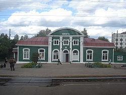
Kezsky District is an administrative and municipal district (raion), one of the twenty-five in the Udmurt Republic, Russia. It is located in the northeast of the republic. The area of the district is 2,321 square kilometers (896 sq mi). Its administrative center is the rural locality of Kez. Population: 22,911 (2010 Census); 26,446 ; 29,264 (1989 Census). The population of Kez accounts for 48.4% of the district's total population.

Kiyasovsky District is an administrative and municipal district (raion), one of the twenty-five in the Udmurt Republic, Russia. It is located in the south of the republic. The area of the district is 821.3 square kilometers (317.1 sq mi). Its administrative center is the rural locality of Kiyasovo. Population: 10,305 (2010 Census); 11,550 ; 12,603 (1989 Census). The population of Kiyasovo accounts for 31.1% of the district's total population.

Kiznersky District is an administrative and municipal district (raion), one of the twenty-five in the Udmurt Republic, Russia. It is located in the southwest of the republic. The area of the district is 2,131.1 square kilometers (822.8 sq mi). Its administrative center is the rural locality of Kizner. Population: 20,263 (2010 Census); 23,502 ; 25,991 (1989 Census). The population of Kizner accounts for 47.1% of the district's total population.

Krasnogorsky District is an administrative and municipal district (raion), one of the twenty-five in the Udmurt Republic, Russia. It is located in the northwest of the republic. The area of the district is 1,860.1 square kilometers (718.2 sq mi). Its administrative center is the rural locality of Krasnogorskoye. Population: 10,347 (2010 Census); 12,219 ; 14,202 (1989 Census). The population of Krasnogorskoye accounts for 42.8% of the district's total population.

Malopurginsky District is an administrative and municipal district (raion), and one of the twenty-five in the Udmurt Republic, Russia. It is located in the south of the republic. The area of the district is 1,223.2 square kilometers (472.3 sq mi). Its administrative center is the rural locality of Malaya Purga. Population: 33,058 (2010 Census); 31,558 ; 30,849 (1989 Census). The population of Malaya Purga accounts for 23.3% of the district's total population.

Mozhginsky District is an administrative and municipal district (raion), one of the twenty-five in the Udmurt Republic, Russia. It is located in the southwest of the republic. The area of the district is 1,997 square kilometers (771 sq mi). Its administrative center is the town of Mozhga. Population: 28,293 (2010 Census); 30,358 ; 30,236 (1989 Census).

Sarapulsky District is an administrative and municipal district (raion), one of the twenty-five in the Udmurt Republic, Russia. It is located in the southeast of the republic. The area of the district is 1,877.6 square kilometers (724.9 sq mi). Its administrative center is the rural locality of Sigayevo. Population: 24,625 (2010 Census); 24,215 ; 25,842 (1989 Census). The population of Sigayevo accounts for 22.9% of the district's total population.

Yakshur-Bodyinsky District is an administrative and municipal district (raion), one of the twenty-five in the Udmurt Republic, Russia. It is located in the center of the republic. The area of the district is 1,780.1 square kilometers (687.3 sq mi). Its administrative center is the rural locality of Yakshur-Bodya. Population: 21,467 (2010 Census); 22,599 ; 22,964 (1989 Census). The population of Yakshur-Bodya accounts for 33.8% of the district's total population.

Uvinsky District is an administrative and municipal district (raion), one of the twenty-five in the Udmurt Republic, Russia. It is located in the southwestern central part of the republic. The area of the district is 2,445.4 square kilometers (944.2 sq mi). Its administrative center is the rural locality of Uva. Population: 39,671 (2010 Census); 40,738 ; 40,876 (1989 Census). The population of Uva accounts for 50.4% of the district's total population.

Vavozhsky District is an administrative and municipal district (raion), one of the twenty-five in the Udmurt Republic, Russia. It is located in the southwest of the republic. The area of the district is 1,679 square kilometers (648 sq mi). Its administrative center is the rural locality of Vavozh. Population: 16,351 (2010 Census); 17,323 ; 18,130 (1989 Census). The population of the administrative center accounts for 35.6% of the district's total population.

Votkinsky District is an administrative and municipal district (raion), one of the twenty-five in the Udmurt Republic, Russia. It is located in the east of the republic. The area of the district is 1,863.8 square kilometers (719.6 sq mi). Its administrative center is the town of Votkinsk. Population: 24,114 (2010 Census); 23,709 ; 22,767 (1989 Census).

Yukamensky District is an administrative and municipal district (raion), one of the twenty-five in the Udmurt Republic, Russia. It is located in the northwest of the republic. The area of the district is 1,019.7 square kilometers (393.7 sq mi). Its administrative center is the rural locality of Yukamenskoye. Population: 10,207 (2010 Census); 11,947 ; 13,172 (1989 Census). The population of Yukamenskoye accounts for 40.2% of the district's total population.
Zavyalovsky District is an administrative and municipal district (raion), one of the twenty-five in the Udmurt Republic, Russia. It is located in the southern central part of the republic. The area of the district is 2,203.3 square kilometers (850.7 sq mi). Its administrative center is the rural locality of Zavyalovo. Population: 66,000 (2010 Census); 59,145 (2002 Census); 53,388 (1989 Census). The population of Zavyalovo accounts for 13.6% of the district's total population.
Syumsi is a rural locality and the administrative center of Syumsinsky District, Udmurtia, Russia. Population: 5,316 (2010 Census); 5,645 (2002 Census); 5,534 (1989 Census).

Uva is a rural locality and the administrative center of Uvinsky District, Udmurtia, Russia. Population: 19,984 (2010 Census); 19,358 (2002 Census); 18,249 (1989 Census).

Sharkan is a rural locality and the administrative center of Sharkansky District, Udmurtia, Russia. Population: 6,614 (2010 Census); 6,596 (2002 Census); 6,532 (1989 Census).

Yakshur-Bodya is a rural locality and the administrative center of Yakshur-Bodyinsky District, Udmurtia, Russia. Population: 7,252 (2010 Census); 6,944 (2002 Census); 6,548 (1989 Census).