
West Midlands is a metropolitan county in the West Midlands Region, England, with a 2021 population of 2,919,600, making it the second most populous county in England after Greater London. It was created in 1974 by the Local Government Act 1972, from parts of Staffordshire, Worcestershire and Warwickshire. The county is a NUTS 2 region within the wider NUTS 1 region of the same name. It embraces seven metropolitan boroughs: the cities of Birmingham, Coventry and Wolverhampton, and the boroughs of Dudley, Sandwell, Solihull and Walsall. The county is overseen by the West Midlands Combined Authority, which covers all seven boroughs and other non-constituent councils, on economy, transport and housing.

West Bromwich is a market town in the borough of Sandwell, West Midlands, England. Historically part of Staffordshire, it is 6.4 miles (10.3 km) north-west of Birmingham. West Bromwich is part of the area known as the Black Country, in terms of geography, culture and dialect. West Bromwich had a population of 77,997 in the 2011 Census.

Smethwick is an industrial town in Sandwell, West Midlands, England. It lies 4 miles (6 km) west of Birmingham city centre. Historically it was in Staffordshire and then Worcestershire before being placed into then West Midlands County.
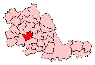
Sandwell is a metropolitan borough of the West Midlands county in England. The borough is named after the Sandwell Priory, and spans a densely populated part of the West Midlands conurbation. According to Sandwell Metropolitan Borough Council, the borough comprises the six amalgamated towns of Oldbury, Rowley Regis, Smethwick, Tipton, Wednesbury, and West Bromwich, although these places consist of numerous smaller settlements and localities.

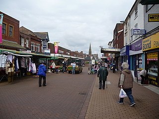
Oldbury is a market town in the Metropolitan Borough of Sandwell, West Midlands, England. It is the administrative centre of the borough and one of its six constituent towns.
Rowley Regis is a town and former municipal borough in Sandwell in the county of the West Midlands, England. It forms part of the area immediately west of Birmingham known as the Black Country and encompasses the three Sandwell council wards of Blackheath, Cradley Heath and Old Hill, and Rowley. At the 2011 census, the combined population of these wards was 50,257.

Blackheath is a town and ward in the Rowley Regis area of the Sandwell Metropolitan Borough, in the county of West Midlands, England.

Sandwell Metropolitan Borough Council was created in 1974 to administer the newly formed Metropolitan Borough of Sandwell, in the West Midlands county of England.

Warley was a short-lived county borough and civil parish in the geographical county of Worcestershire, England, forming part of the West Midlands conurbation. It was formed in 1966 by the combination of the existing county borough of Smethwick with the municipal boroughs of Oldbury and Rowley Regis, by recommendation of the Local Government Commission for England. It was abolished just 8 years later in 1974 under the Local Government Act 1972, with its area passing to the Metropolitan Borough of Sandwell.

Brandhall is a suburb of Oldbury in the south of the Metropolitan Borough of Sandwell, West Midlands, bordering Birmingham and Halesowen. The development of the area commenced during the 1930s with the construction of several hundred private houses along the Hagley Road and Wolverhampton Road, as well as several side roads leading off the main dual carriageways. However, most of Brandhall was developed in the 1950s and 1960s, when several thousand council houses, flats and bungalows were built by Oldbury Council. Most of the high and medium-rise flats in Brandhall were demolished in the early 2000s and in their place housing associations built new low-rise homes. Brandhall is growing to be a more popular place due to the construction of new facilities, such as a local supermarket and a doctor's surgery.

Cradley Heath is a town in the Rowley Regis area of the Metropolitan Borough of Sandwell, West Midlands, England approximately 2 miles (3 km) north-west of Halesowen, 3 miles (5 km) south of Dudley and 8 miles (13 km) west of central Birmingham. Cradley Heath is often confused with the neighbouring Halesowen district of Cradley from which it is separated by the River Stour; both are in the Black Country but have long been administered by different local authorities, and until 1966 were in separate counties.
Warley is a constituency in the House of Commons of the UK Parliament. The constituency was established in 1997, and has been represented since that date by John Spellar, a member of the Labour Party.

Bearwood is the southern part of Smethwick, Sandwell, West Midlands, England, and north of the A456 Hagley Road. Bearwood Hill was the original name of the High Street from Smethwick Council House to Windmill Lane. The border at the Shireland Brook where Portland Road (Edgbaston) becomes Shireland Road (Sandwell) is signed "Bearwood".
Warley is a residential area of Oldbury in the Metropolitan Borough of Sandwell in the West Midlands of the United Kingdom. Historically in both Worcestershire and Shropshire, the name has been used for both a civil parish (1884–1908) and a county borough (1966–1974). Warley has been the name of a UK Parliament constituency since 1997.
Q3 Academy Langley is a coeducational secondary school located in the Langley Green area of Oldbury in the West Midlands of England.

West Bromwich Town Hall is a municipal building in West Bromwich, West Midlands, England. It is a Grade II listed building.
Galton Village is a residential area of Smethwick, West Midlands, England. It takes its name from the iconic nearby Galton Bridge that was named after local business man Samuel Galton whose land the new BCN Main Line canal was built through, the canal runs behind Galton Village as does the Stour Valley section of West Coast Mainline. The Oldbury Road runs through the area which begins next to Smethwick’s Galton Bridge railway station and ends at Spon Lane, next to a small shopping centre.

Sandwell Community History and Archives Service (CHAS) is the archive service for the Metropolitan Borough of Sandwell in the West Midlands of England. The service is based within Smethwick Library. It collects and preserves original archives and published material relating to the history of Sandwell. It is a local authority archive service, run and funded by Sandwell Metropolitan Borough Council.

Smethwick Council House is a municipal building in Smethwick, West Midlands, England. The building, which is located on High Street and was once the headquarters of Smethwick Borough Council, is now a Grade II listed building.

