
Georgetown County is a county located in the U.S. state of South Carolina. As of the 2020 census, the population was 63,404. Its county seat is Georgetown. The county was founded in 1769. It is named for George III of the United Kingdom.

Georgetown is the third oldest city in the U.S. state of South Carolina and the county seat of Georgetown County, in the Lowcountry. As of the 2010 census it had a population of 9,163. Located on Winyah Bay at the confluence of the Black, Great Pee Dee, Waccamaw, and Sampit rivers, Georgetown is the second largest seaport in South Carolina, handling over 960,000 tons of materials a year, while Charleston is the largest.

Murrells Inlet is an unincorporated area and census-designated place in Georgetown County, South Carolina, United States. The population was 7,547 at the 2010 census. It is about 13 miles south of Myrtle Beach, South Carolina and 21 miles north of Georgetown, the county seat.

Huntington Beach State Park is a 2500 acre coastal preserve and state park near Murrells Inlet, in Georgetown County, South Carolina. It has a large sandy beach, few beach-goers, and numerous wild birds to watch over the seasons.

The Watervale Historic District is a resort, originally constructed as a lumber camp, located at 975-1422 Watervale Road on the shore of Lower Herring Lake in Blaine Township, Michigan. It was designated a Michigan State Historic Site in 1991 and listed on the National Register of Historic Places in 2003.

South Carolina Highway 707 (SC 707) is a 12.645-mile (20.350 km) state highway in Georgetown and Horry counties, in the northeastern part of the U.S. state of South Carolina, in the Myrtle Beach metropolitan area. It begins at U.S. Highway 17 Business in Murrells Inlet to US 17 across from Farrow Parkway near Socastee, South Carolina.

Atalaya Castle, often known simply as Atalaya, was the winter home of industrialist and philanthropist Archer M. Huntington and his wife, the sculptor Anna Hyatt Huntington, located in Huntington Beach State Park near the Atlantic coast in Murrells Inlet, Georgetown County, South Carolina.

The High Hills of Santee, sometimes known as the High Hills of the Santee, is a long, narrow hilly region in the western part of Sumter County, South Carolina. It has been called "one of the state's most famous areas". The High Hills of Santee region lies north of the Santee River and east of the Wateree River, one of the two rivers that join to form the Santee. It extends north almost to the Kershaw county line and northeasterly to include the former summer resort town of Bradford Springs. Since 1902 the town has been included in Lee County.
Hobcaw Barony is a 16,000-acre (65 km2) tract on a peninsula called Waccamaw Neck between the Winyah Bay and the Atlantic Ocean in Georgetown County, South Carolina. Much of Hobcaw Barony is south of US Highway 17. The land was purchased by the investor, philanthropist, presidential advisor, and South Carolina native Bernard M. Baruch between 1905 and 1907 for a winter hunting retreat. Later, his eldest child, Belle W. Baruch, began purchasing the property from her father beginning in 1936. By 1956, Belle owned Hobcaw Barony entirely. Upon her death in 1964, the property was transferred to the Belle W. Baruch Foundation for a nature and research preserve. The property includes more than 37 historic buildings and structures representative of the eras of both 18th & 19th century rice cultivation and 20th century winter retreats. Hobcaw Barony was named to the National Register of Historic Places on November 2, 1994.

This is a list of the National Register of Historic Places listings in Georgetown County, South Carolina.

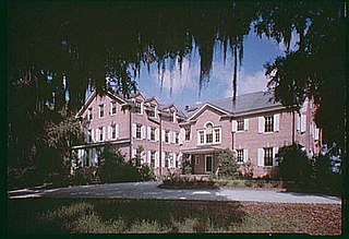
Arcadia Plantation, originally known as Prospect Hill Plantation, is a historic plantation house located near Georgetown, Georgetown County, South Carolina. The main portion of the house was built about 1794, as a two-story clapboard structure set upon a raised brick basement in the late-Georgian style. In 1906 Captain Isaac Edward Emerson, the "Bromo-Seltzer King" from Baltimore, purchased the property. Two flanking wings were added in the early 20th century. A series of terraced gardens extend from the front of the house toward the Waccamaw River. Also on the property is a large two-story guest house, tennis courts, a bowling alley, stables, five tenant houses and a frame church. The property also contains two cemeteries and other plantation-related outbuildings.

Beneventum Plantation House, originally known as Prospect Hill Plantation, is a historic plantation house located near Georgetown, Georgetown County, South Carolina. It was built about 1750, and is a two-story, five-bay, Georgian style house. It features a one-story portico across the center two-thirds of the façade. The rear half of the house was added about 1800, with further rear additions made probably early-20th century. It was the home of Christopher Gadsden, a prominent statesmen and soldier of the American Revolution, the originator of the “Don’t Tread on Me” flag, and Federalist Party leader in the early national period.
Keithfield Plantation is a historic rice plantation property and national historic district located near Georgetown, Georgetown County, South Carolina. The district encompasses 1 contributing building, 1 contributing site, and 3 contributing structures. They include a slave cabin, built about 1830, and agricultural features including examples of historic ricefields, canals, dikes, and trunks. The original main house burned in the mid-20th century. Keithfield was one of several productive rice plantations on the Black River.

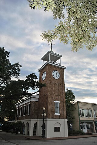
Georgetown Historic District is a national historic district located at Georgetown, Georgetown County, South Carolina. The district encompasses 49 contributing buildings in the central business district of Georgetown. The oldest existing structure in Georgetown is a dwelling which dates from about 1737. There are approximately 28 additional 18th century structures as well as 18 buildings erected during the 19th century prior to the American Civil War. The existing structures—homes, churches, public buildings—are of both historical and architectural significance and are situated on heavily shaded, wide streets. The architecture ranges from the simplicity of early colonial, or Georgian, to the elaborate rice plantation era, such as Classical Revival. Notable buildings include the Georgetown County Courthouse, U.S. Post Office, The Rice Museum, Winyah Indigo Society Hall, Masonic Lodge, Antipedo Baptist Church Cemetery, Prince George Winyah Episcopal Church complex, St. Mary's Catholic Church, Kaminski Building, Mary Man House, Dr. Charles Fyffe / Middleton House, John Cleland / Allston House, Samuel Sampson / Henning-Ward House, Robert Stewart / George Pawley House, Martha Allston Pyatt /John S. Pyatt House, Eleazar Waterman / Withers House, and William Waties / Withers House.
Old Market Building, also known as the Rice Museum, is a historic public market building located at Georgetown, Georgetown County, South Carolina. It was built in 1832–1835, and is a one-story, Classical Revival temple-form building on a high arcaded base.

Pawleys Island Historic District is a national historic district located at Pawleys Island, Georgetown County, South Carolina. The district encompasses 12 contributing buildings and contains buildings ranging from ca. 1780 to post World War I, and includes shoreline which the owners of these homes think they own, and marshland. The building style is a variation of West Indian architecture which has been adapted to Pawleys climatic conditions. The original houses on Pawleys are not mansions but summer retreats, sturdily built and large enough to accommodate big families. Designed for the greatest degree of ventilation, with porches on multiple sides and with high brick foundations providing protection against gale tides, many of the 20th-century buildings have adhered to the traditional design that has proven well suited to this environment. The houses are equipped with large chimneys and fireplaces. Breezeways attached at the rear of the houses led to the kitchens. Servant's quarters were usually one or two room cabins equipped with fireplaces.
Richmond Hill Plantation Archeological Sites consists of five historic archaeological sites located near Murrells Inlet, Georgetown County, South Carolina. The Richmond Hill Plantation complex sites include remains of the planter's house, two possible overseers' houses, approximately 20 slave houses, a slave cemetery, a rice barn, and rice fields and dikes. The plantation house, overseers' houses, and slave houses were all burned by about 1930. Richmond Hill plantation was owned by Dr. John D. Magill, who was considered one of the least efficient planters in the area and the most brutal slaveowner among the Georgetown District rice planters.

Woodside Cotton Mill Village Historic District is a national historic district located in Greenville County, South Carolina. The district encompasses 278 contributing buildings and 2 contributing sites in an early 20th century urban South Carolina textile mill village. Centered on a mill founded by John T. Woodside in 1902, the district is located just west of the city limits of Greenville and is largely intact despite modernizations made by a succession of mill and home owners. The mill itself is a rectangular, brick, four-story building designed by J.E. Sirrine and built between 1902 and 1912. Eventually the mill became the largest cotton mill under one roof in the United States and one of the largest in the world.
Glenn Springs Historic District is a national historic district located at Glenn Springs, Spartanburg County, South Carolina. It encompasses 18 contributing buildings and 3 contributing sites in the historic health resort of Glenn Springs. The community developed as a resort around the mineral springs between about 1840 and 1940. The district includes several residences, two boarding houses, Cates House Ruins, Calvary Protestant Episcopal Church, Presbyterian Church, Cates Store, Glenn Springs Post Office, a pavilion, a cemetery, and the site of the Glenn Springs Hotel. It includes notable buildings in the Greek Revival, Gothic Revival, Queen Anne, and Bungalow styles.

Mount Pleasant Historic District is a national historic district located at Mount Pleasant, Charleston County, South Carolina. The district encompasses nine contributing buildings in the town of Mount Pleasant. The dwellings reflect Mount Pleasant's historic role as a summer resort town. The building reflect architectural styles of the 18th, 19th and early 20th centuries, including vernacular Georgian, Greek Revival and Gothic Revival. Notable buildings include the Mount Pleasant Presbyterian Church, St. Andrew's Episcopal Church, Mount Pleasant Seventh-Day Adventist Church, Hibben-McIver House, 200 Bank Street, and the Captain Peter Lewis House. Located in the district is the separately listed Old Courthouse.


