
Askham Richard is a village and civil parish in the unitary authority of City of York in the north of England, 6.5 miles (10.5 km) south-west of York, close to Copmanthorpe, Bilbrough and Askham Bryan. The population of the civil parish at the 2011 census was 351. The village became a Conservation Area in 1975. Nearby is Askham Bryan College of Agriculture.

Haxby is a town and civil parish in the City of York district of North Yorkshire, England. According to the 2001 census the parish had a population of 8,754, reducing to 8,428 at the 2011 Census.
Nether Poppleton is a village and civil parish in the unitary authority of the City of York in North Yorkshire, England. It is by the west bank of the River Ouse and is adjacent to Upper Poppleton west of York. It is close to the A59 road from York to Harrogate. The village is served by Poppleton railway station on the Harrogate Line.
Upper Poppleton is a village and civil parish in the unitary authority of the City of York in North Yorkshire, England. It is situated by the west bank of the River Ouse adjacent to Nether Poppleton, and west of York close to the A59 from York to Harrogate. The village is served by Poppleton railway station on the Harrogate Line. According to the 2001 census, the parish had a population of 1,961, increasing to 1,997 at the 2011 Census. Before 1996, it was part of the Borough of Harrogate.

Osbaldwick is a village and civil parish in the unitary authority of the City of York in North Yorkshire, England. The population of the civil parish as taken at the Census 2011 was 2,902. It has been in existence since at least the 11th century, and was declared a conservation area in 1978. It is the burial place of the nun Mary Ward.
Fulford is a historic village and civil parish on the outskirts of York, in the York district, in the ceremonial county of North Yorkshire, England. Fulford is located 2 miles (3 km) to the south of the city, on the east bank of the River Ouse.

Ryedale was a non-metropolitan district in North Yorkshire, England. It was in the Vale of Pickering, a low-lying flat area of land drained by the River Derwent. The Vale's landscape is rural with scattered villages and towns. It has been inhabited continuously from the Mesolithic period. The economy was largely agricultural with light industry and tourism playing an increasing role.

Dunnington is a village and civil parish in the City of York and ceremonial county of North Yorkshire, England. The population of the civil parish was 3,230 at the 2011 Census. The village is approximately 4 miles (6 km) east from York city centre. The parish includes the hamlet of Grimston.

Wheldrake is a village and civil parish located 7 miles (11 km) south-east of York in the unitary authority of the City of York, which is in the ceremonial county of North Yorkshire, England. According to the 2001 census the parish had a population of 1,909, increasing to 2,107 at the 2011 Census.

Skelton is a village and civil parish in the unitary authority of the City of York, in North Yorkshire, England. It is four miles (6.4 km) north-north-west of the city of York, west of Haxby, and on the east bank of the River Ouse. Skelton was in the ancient royal Forest of Galtres and covers 977.3 hectares (3.77 sq mi). Skelton was made a conservation area in 1973.

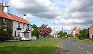
Stockton-on-the-Forest is a village and civil parish in the unitary authority of the City of York in North Yorkshire, England.

Wigginton is a village and civil parish in the unitary authority of the City of York in North Yorkshire, England. It is situated 4 miles (6.4 km) north of York. According to the 2001 census the parish had a population of 3,714, reducing to 3,610 at the 2011 Census.

Earswick is a village and civil parish in the unitary authority of the City of York in North Yorkshire, England. It lies between Huntington and Strensall about 4 miles (6.4 km) north of York.
Hessay is a village and civil parish in the unitary authority area of the City of York, in the ceremonial county of North Yorkshire, England 4.7 miles (7.5 km) west of York.

Holtby is a small village and civil parish in the unitary authority of the City of York in North Yorkshire, England. The population at the 2011 Census was 166. It lies close to the A166 about 5 miles (8 km) east of York.

Deighton is a village and civil parish in the unitary authority of the City of York, North Yorkshire, England. The population of the civil parish as of the 2011 census was 291. It lies on the A19 about five miles south of York. According to the 2001 census the parish had a population of 308.

Naburn is a small village and civil parish in the unitary authority of the City of York in the ceremonial county of North Yorkshire, England. It lies on the eastern side of the River Ouse about 4 miles (6.4 km) south of York. According to the 2001 census the parish had a population of 470, increasing to 516 at the 2011 census.

Thorganby is a small village and civil parish in North Yorkshire, England. It was historically part of the East Riding of Yorkshire until 1974, but from 1974 to 2023 was in the Selby District of the shire county of North Yorkshire. In 2023 the district was abolished and North Yorkshire became a unitary authority.

Hemingbrough is a small village and civil parish in North Yorkshire, England that is located approximately 5 miles (8 km) from Selby and 4 miles (6.4 km) from Howden on the A63. It was in the historic East Riding of Yorkshire, but since 1974 has come under North Yorkshire. The village has a 12th-century former collegiate church, a Methodist chapel and shops. The village also has a primary school and nursery as well as a playing field for the local children. The surrounding area makes up part of the Humberhead Levels and is flat land mainly used for mixed agriculture. It is thought that from this village came Walter of Hemingbrough, one of Britain's early chroniclers. Writing in the 14th century, he gave us a history beginning with the Norman conquest, now in the British Museum.
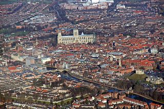
The City of York, officially simply "York", is a unitary authority area with city status in the ceremonial county of North Yorkshire, England.


