Sir John Grey Gorton was the nineteenth Prime Minister of Australia, in office from 1968 to 1971. He led the Liberal Party during that time, having previously been a long-serving government minister.

Protected areas of South Australia consists of protected areas located within South Australia and its immediate onshore waters and which are managed by South Australian Government agencies. As of March 2018, South Australia contains 359 separate protected areas declared under the National Parks and Wildlife Act 1972, the Crown Land Management Act 2009 and the Wilderness Protection Act 1992 which have a total land area of 211,387.48 km2 (81,617.16 sq mi) or 21.5% of the state's area.
Protected areas of Tasmania consist of protected areas located within Tasmania and its immediate onshore waters, including Macquarie Island. It includes areas of crown land managed by Tasmanian Government agencies as well as private reserves. As of 2016, 52% of Tasmania's land area has some form of reservation classification, the majority is managed by the Tasmania Parks & Wildlife Service. Marine protected areas cover about 7.9% of state waters.

Flinders Chase National Park is a protected area in the Australian state of South Australia located at the west end of Kangaroo Island about 177 kilometres west-south west of the state capital of Adelaide and 110 kilometres west of the municipal seat of Kingscote. It is a sanctuary for endangered species and home to a few geological phenomena. It was the second national park to be declared in South Australia.

Greenmount National Park is a national park in the locality of Greenmount, Western Australia, 22 km east of Perth.

John Forrest National Park is a national park in the Darling Scarp, 24 km (15 mi) east of Perth, Western Australia. Proclaimed as a national park in November 1900, it was the first national park in Western Australia and the second in Australia after Royal National Park.

Yanchep is a national park in Western Australia, 42 kilometres (26 mi) north of Perth adjacent to the locality of the same name Yanchep.

Coolbellup is a suburb in Perth, Western Australia, located 15 kilometres (9.3 mi) south of the central business district within the local government area of the City of Cockburn.

North Central Victoria is a rural region in the Australian state of Victoria. The region lies to the south of the Victorian/New South Wales border as defined by the Murray River, to the southwest of the Hume region, to the west of the Great Dividing Range contained within the Central Highlands and Victorian Alps, to the north of Greater Melbourne, to the northeast of the Wimmera, and to the east of the Mallee region.

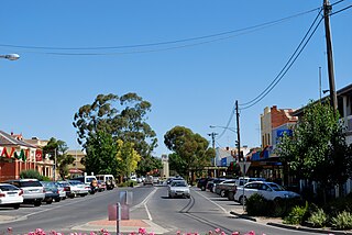
Kerang is a rural town on the Loddon River in northern Victoria in Australia. It is the commercial centre to an irrigation district based on livestock, horticulture, lucerne and grain. It is located 279 kilometres (173 mi) north-west of Melbourne on the Murray Valley Highway a few kilometres north of its intersection with the Loddon Valley Highway, elevation 78 metres (256 ft). At the 2016 census, Kerang had a population of 3,893. Kerang is believed to be an Aboriginal word for Cockatoo. It is home to the largest solar and battery farm in the country which was opened in June 2019. The 50-megawatt battery system is located outside of Kerang and stores 100 per cent renewable energy. The 2,000 solar panels have become a tourist attraction and are drawing many businesses to the town.

Golden Bay is an outer southern suburb of Perth, the capital city of Western Australia, located within the City of Rockingham. The suburb is located between Secret Harbour and Singleton, and just off the Mandurah Road. Originally known as Peelhurst, the locality name was officially changed in 1985. Golden Bay shore is a segment of the Swan Coastal Plain, which runs along the coast of the Indian Ocean.

Ultima is a town in northern Victoria, Australia. The town is in the Rural City of Swan Hill local government area, 353 kilometres (219 mi) north-west of the state capital, Melbourne and 35 kilometres (22 mi) south of Swan Hill. At the 2016 census, Ultima had a population of 174, down from 333 in 2011.

The Carrington Falls is a plunge waterfall across the Kangaroo River located in the Southern Highlands region of New South Wales, Australia.

The Piangil railway line is a 5 ft 3 in gauge (1600 mm) railway line in north-western Victoria, Australia. It branches off the Deniliquin line just north of Bendigo, and runs in a north-westerly direction through Pyramid Hill and Kerang to the border town of Swan Hill, then roughly parallels the New South Wales border to Piangil and Yungera. The line is now open only as far as Piangil, and passenger services only operate to Swan Hill.
Lalbert is a very small farming town in the north-west of Victoria, Australia, within the Shire of Gannawarra. Lalbert is situated 50 kilometres (31 mi) west of Kerang on the Swan Hill-Donald Road. At the 2016 census, Lalbert had a population of 151 declining from 224 just five years earlier.
Lake Charm is a small town situated on the Murray Valley Highway, just west of a lake of the same name. Located in the northwest of Victoria, Australia, within the Shire of Gannawarra. Lake Charm is 19 km from Kerang. At the 2011 census, Lake Charm and the surrounding area had a population of 311.

Pelican Lagoon Conservation Park is a protected area located in the Australian state of South Australia on the Dudley Peninsula on Kangaroo Island. It was dedicated in 1967 for the protection of wildlife habitat.
Western River Wilderness Protection Area, formerly the Western River Conservation Park and the Western River National Park, is a protected area in the Australian state of South Australia located on the north coast of Kangaroo Island about 30 kilometres (19 mi) west of Parndana in the gazetted locality of Western River. Waterfall Creek, with its scenic Billy Goat Waterfall, are within the area.
Belt Hill Conservation Park is a protected area located in the Australian state of South Australia in the locality of Thornlea about 317 kilometres (197 mi) south-east of the state capital of Adelaide and about 4 kilometres (2.5 mi) north west of the town centre in Hatherleigh.
Bullock Hill Conservation Park is a protected area located in the Australian state of South Australia in the locality of Ashbourne about 45 kilometres (28 mi) south of the state capital of Adelaide and about 10 kilometres (6.2 mi) south-west of the town of Strathalbyn.


