
Schruns is a municipality in the Montafon valley, in the Bludenz district of the westernmost Austrian state of Vorarlberg.

Hochfilzen is a town and municipality in the Kitzbühel district of the Austrian state of Tyrol. It is located in the Pillersee valley 5 km east of Fieberbrunn. Population was 1,147 in 2016.

Sankt Anton am Arlberg, commonly referred to as St Anton, is a village and ski resort in the Austrian state of Tyrol. It lies in the Tyrolean Alps, with aerial tramways and chairlifts up to 2,811 m (9,222 ft), yielding a vertical drop of 1,507 m (4,944 ft). It is also a popular summer resort among trekkers and mountaineers.
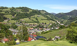
Losenstein is a small village in the south of Upper Austria, Austria. About 1,700 inhabitants call Losenstein their home. It lies in the southernmost quarter of Upper Austria called "Traunviertel". Its spatial dimension from North to South is 8,1 km, from West to East 4,5 km. 45,9% of its area are covered by forests, another 39,7% are used for agricultural purposes. The closest city of administrative importance is Steyr, which is 20 km to North. It can be accessed via the "B-109 Eisenbundesstrasse" or by train.

Ellmau is a municipality in the district of Kufstein in the Austrian region of Sölllandl. It lies 12 km southeast of Kufstein and 9 km west of Sankt Johann in Tirol. It is located at an elevation of 820 m above sea level. It was mentioned for the first time in the records in 1155 and is nowadays part of the Ski Welt skiing area.

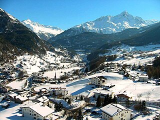
Galtür is a village and ski resort in the upper Paznaun valley in Austrian state of Tyrol located in the Central Eastern Alps 35 km southwest of Landeck near the border of Vorarlberg and Switzerland.

Bad Mitterndorf is a town in Salzkammergut in the Austrian state of Styria.

Schladming is a small former mining town in the northwest of the Austrian state of Styria that is now a popular tourist destination. It has become a large winter-sports resort and has held various skiing competitions, including most notably the FIS Alpine World Ski Championships 1982 and the FIS Alpine World Ski Championships 2013. The shopping area has many cafes and restaurants, and a variety of shops that cater to tourists.
Sölden is a municipality in the Ötztal valley of Tyrol, Austria.
Saalbach-Hinterglemm is a municipality in the district of Zell am See, in the Austrian state of Salzburg. It is well known for its skiing and other winter sports. A four-piste network consisting of Saalbach, Hinterglemm, Fieberbrunn and Leogang is located in the municipality, adding up to 270 kilometres (170 mi) of ski slopes. It is short transfer to resort from Salzburg Airport.

Bad Kleinkirchheim is a municipality and spa town in the district of Spittal an der Drau, in Carinthia, Austria.

Haus im Ennstal is a village in central Austria, located in the Liezen district of Styria. It is an important town on the Enns river and is at the foot of Hauser Kaibling.

Rennweg am Katschberg is a market town in the district of Spittal an der Drau in Carinthia, Austria.
Wildschönau is a municipality within the district of Kufstein in the state of Tyrol 6 km south of Wörgl.

Semmering is a town in the district of Neunkirchen in the Austrian state of Lower Austria. It is noted for its skiing, and has hosted the Alpine skiing World Cup several times. When the Semmering Railway was completed in 1854, the town quickly became a popular tourist getaway in winter months. In 2011, the town had a permanent population of 571.

Brand is a municipality in the district of Bludenz in the Austrian state of Vorarlberg.
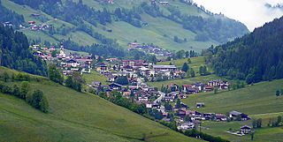
Westendorf is a municipality and a village in the Kitzbühel district in the Austrian state of Tyrol located 13.7 km west of Kitzbühel and 12 km southeast of Wörgl in the Brixental valley. The community is a popular ski resort as well as a popular location for Summer tourism especially for excursions and walking-tours. Westendorf was mentioned for the first time in documents in 1234. It has 21 village parts.

Scheffau am Wilden Kaiser is a municipality in the district Kufstein in the Austrian region of the Sölllandl. It is located 8.50 km southeast of Kufstein and 13 km northwest of Kitzbühel and has three subdivisions. The main source of income is summer tourism. The village has a public swimming area.
Söll is a municipality in the district of Kufstein in the Austrian region of Sölllandl. It is located 9 km south of Kufstein and 9 km east of Wörgl. The village consists of 25 subdivisions. The main sources of income are agriculture and tourism.

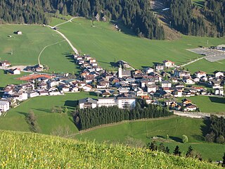
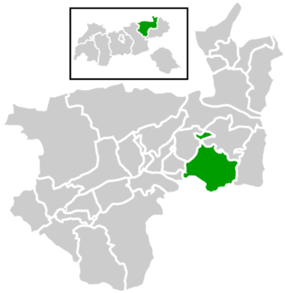
Mieders is a municipality in the southern part of the district Innsbruck-Land in the Austrian state of Tyrol. It is located on the right side of the Stubaital 10.60 km south of Innsbruck.


