N5 (South Africa)

Last updated

SA road N5.svg
National route N5
Map of the N5 (South Africa) with labels.svg
Route information
Maintained by SANRAL
Length235 km (146 mi)
Major junctions
West endSA road N1 jct.svg N1 at Winburg
East endSA road N3 jct.svg N3 at Harrismith
Location
Country South Africa
Provinces Free State
Major cities Bethlehem, Harrismith
Highway system
SA road N4.svg N4 SA road N6.svg N6

The N5 is a national route in South Africa that connects the N1 at Winburg with the N3 at Harrismith, via Senekal, Paul Roux and Bethlehem. [1]

Contents

It forms part of the main route between Durban and Bloemfontein.

Route

The N5 begins in Winburg, at an interchange with the N1 and the R708 north-west of the town centre. It is initially co-signed with the R708 eastwards, bypassing Winburg to the north (where the R709 provides access to the town centre). After 9 kilometres, the R708 becomes its own road south-east towards Marquard, leaving the N5 as the easterly road. [1]

From the R708 split east of Winburg, the N5 heads east for 54 kilometres to the town of Senekal. In Senekal West, the N5 is joined by the R70 from Ventersburg and the R707 from Marquard and they form one road eastwards through the Senekal town centre as Voortrekker Street. After 8 kilometres, east of Senekal, the R707 becomes its own road to the north-east and after another kilometre, the R70 becomes its own road to the south-east. [1]

From the R70 split east of Senekal, the N5 heads eastwards for 60 kilometres, through Paul Roux, to the city of Bethlehem, where it passes through the city centre as two one-way-streets (Muller Street eastwards and Kerk Street westwards). In the Bethlehem City Centre, the N5 meets the R26 and the south-eastern terminus of the R76 at the Commissioner Street junction. The R26 joins the N5 and they are co-signed eastwards through the city centre up to the Hospital Road junction, where the R26 becomes the road northwards and the N5 becomes the road southwards. It turns to the south-east and meets the western terminus of the R712 before crossing the As River. [1]

From Bethlehem, the N5 heads eastwards for 37 kilometres to bypass the town of Kestell and meet the R57 at an off-ramp junction north of the town centre. From Kestell, the N5 heads eastwards for 41 kilometres to meet the north-western terminus of the R74 and enter the city of Harrismith. Just south of the Harrismith City Centre, the N5 crosses the Wilge River and reaches its eastern terminus at an interchange with the N3. [1]

Related Research Articles

<span class="mw-page-title-main">N3 (South Africa)</span> National road in South Africa

The N3 is a national route in South Africa that connects Johannesburg and Durban, respectively South Africa's largest and third-largest cities. Johannesburg is the financial and commercial heartland of South Africa, while Durban is South Africa's key port and one of the busiest ports in the Southern Hemisphere and is also a holiday destination. Durban is the port through which Johannesburg imports and exports most of its goods. As a result, the N3 is a very busy highway and has a high volume of traffic.

<span class="mw-page-title-main">N1 (South Africa)</span> National road in South Africa

The N1 is a national route in South Africa that runs from Cape Town through Bloemfontein, Johannesburg, Pretoria and Polokwane to Beit Bridge on the border with Zimbabwe. It forms the first section of the famed Cape to Cairo Road.

<span class="mw-page-title-main">Bethlehem, South Africa</span> City in Free State, South Africa

Bethlehem is a city in the eastern Free State province of South Africa that is situated on the Liebenbergs river along a fertile valley just north of the Rooiberg Mountains on the N5 road. It is the fastest growing city in the Free state province, with its target of being the third largest city after Bloemfontein and Welkom.

<span class="mw-page-title-main">Senekal</span> Place in Free State, South Africa

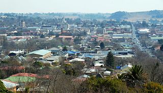
Senekal is a town situated on the banks of the Sand River in the eastern part of the Free State province of South Africa. It was named after Commandant FP Senekal. It is the second largest town in Setsoto Municipality after Ficksburg, the largest town and capital of Setsoto. Senekal lies on the N5 national road between Winburg on the west and Bethlehem to the east. It has two townships, Matwabeng and OR Tambo Section, the latter being the latest, largest and fastest growing.

<span class="mw-page-title-main">R26 (South Africa)</span>

The R26 is a provincial route in Free State, South Africa that connects Rouxville with Villiers via Zastron, Wepener, Ladybrand, Ficksburg, Bethlehem & Reitz.

<span class="mw-page-title-main">R30 (South Africa)</span> Road in South Africa

The R30 is a provincial route in South Africa that connects Bloemfontein with Rustenburg via Brandfort, Welkom, Bothaville, Klerksdorp and Ventersdorp. The southern part of the route is tolled, as the R30 forms the first section of the ZR Mahabane Toll Route, with the Brandfort Toll Plaza found 10 kilometres north of its Southern junction with the N1 National Route. The tolled portion ends at the junction with the R730.

<span class="mw-page-title-main">R34 (South Africa)</span> Road in South Africa

The R34 is a long provincial route in South Africa that connects Vryburg with Richards Bay via Kroonstad and Newcastle. It passes through three provinces, North West, the Free State and KwaZulu-Natal.

<span class="mw-page-title-main">R36 (South Africa)</span>

The R36 is a provincial route in South Africa that connects the N1 with Ermelo, via Tzaneen and Lydenburg. It is co-signed with the N4 for 8 kilometres between Machadodorp and Patattanek, with a tollgate on this section. It used to extend further south past Ermelo to Amersfoort, but that section is now designated as part of the N11.

<span class="mw-page-title-main">R57 (South Africa)</span> Road in South Africa

The R57 is a provincial route in South Africa that connects Vanderbijlpark with Phuthaditjhaba via Sasolburg, Heilbron and Reitz.

<span class="mw-page-title-main">R70 (South Africa)</span>

The R70 is a provincial route in the Free State Province, South Africa that connects Odendaalsrus with Ficksburg via Ventersburg and Senekal.

<span class="mw-page-title-main">R74 (South Africa)</span>

The R74 is a provincial route in South Africa that connects Harrismith with KwaDukuza on the coast, via Oliviershoek Pass, Bergville, Winterton, Colenso, Weenen and Greytown.

<span class="mw-page-title-main">R76 (South Africa)</span> Road in South Africa

The R76 is a provincial route in Free State, South Africa that connects Orkney with Bethlehem via Kroonstad.

<span class="mw-page-title-main">N12 (South Africa)</span> National road in South Africa

The N12 is a national route in South Africa which runs from George through Beaufort West, Kimberley, Klerksdorp and Johannesburg to eMalahleni.

<span class="mw-page-title-main">N8 (South Africa)</span> National road in South Africa

The N8 is a national route in South Africa that connects Groblershoop with Maseru in Lesotho via Kimberley and Bloemfontein. It is maintained by the South African National Roads Agency.

<span class="mw-page-title-main">N11 (South Africa)</span> National road in South Africa

The N11 is a national route in South Africa which runs from the Botswana border at Groblersbrug, through Mokopane, Middelburg, Ermelo and Newcastle to end at the N3 just after Ladysmith.

The R700 is a regional route in Free State, South Africa that connects Hoopstad with Bloemfontein via Bultfontein and Soutpan.

The R707 is a Regional Route in Free State, South Africa that connects Frankfort with Marquard via Petrus Steyn, Lindley, Arlington and Senekal.

The R708 is a Regional Route in South Africa that connects Jan Kempdorp in the Northern Cape with Clocolan in the Free State via Christiana, Hertzogville, Bultfontein, Theunissen, Winburg and Marquard.

The R720 is a Regional Route in Free State, South Africa that connects Vredefort with Senekal via Koppies, Edenville and Steynsrus.

References

  1. 1 2 3 4 5 Falkner, John (May 2012). South African Numbered Route Description and Destination Analysis (Report). National Department of Transport. p. 18. Archived from the original on 6 June 2014. Retrieved 12 August 2014.