
Atmore is a city in Escambia County, Alabama, United States. It was incorporated in 1907. As of the 2020 census, it has a population of 8,391. Atmore is in the planning stages to increase its economic base with additions in its new Rivercane development along the I-65 corridor.
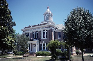
Rison is a city in and the county seat of Cleveland County, Arkansas, United States. Its population was 1,344 at the 2010 U.S. census. It is included in the Pine Bluff, Arkansas Metropolitan Statistical Area. Rison is a bedroom community for people who work in Pine Bluff. The largest employers are the city and county governments, the Cleveland County School District, the Cleveland County Nursing Home. There are two banks, eight churches, and about forty-five businesses within the city limits. Among the local properties listed on the National Register of Historic Places are the Rison Cities Service Station and the Rison Texaco Service Station.

Caryville is a town in Washington County, Florida, United States located along the Choctawhatchee River. The population was 411 at the 2010 census.

Charlton Township is a civil township of Otsego County in the U.S. state of Michigan. The population was 1,350 at the 2020 census.

Gould City is an unincorporated community in Mackinac County in the U.S. state of Michigan. The community is located within Newton Township. As an unincorporated community, Gould City has no legal autonomy of its own but does have its own post office with the 49838 ZIP Code.
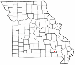
Hunter is an unincorporated community and census-designated place in Carter County, Missouri, United States. As of the 2020 census it had a population of 95.
Lemonville is a ghost town that was the site of the Lemon Lumber Company in northern Orange County, Texas, United States, in the southeastern part of the state. Sometimes referred to as Lemon, it is located north of Orange and just east of Mauriceville. The town plat was filed in 1901 by a man named William Manuel, with the location chosen for its proximity to the tracks of the Kansas City Southern Railroad. In 1902, when the population was about 300, a post office was established, with Cornelius P. Ryan as first postmaster.

Bridal Veil is a virtual ghost town located in Multnomah County, Oregon, United States. It was established in the 1880s during a logging boom by a logging company as it harvested timber on nearby Larch Mountain to be a company mill town around a sawmill. It had a close relationship with the logging town of Palmer for the first 50 years of its history. As of November 2011, all that remains of the town is a post office and a cemetery. The site is located near the west end of the Columbia River Gorge.
Austin is an unincorporated community, considered a ghost town, in Grant County, Oregon, United States. It is located north of Oregon Route 7, near the Middle Fork John Day River in the Malheur National Forest.

Garnet is an unincorporated community in Mackinac County in the U.S. state of Michigan. The community is located within Hudson Township. As an unincorporated community, Garnet has no legally defined boundaries or population statistics of its own.

Buffalo City was a logging and moonshine town in East Lake Township, Dare County, North Carolina, United States. It was on the mainland, 19 miles (31 km) west of Manteo near present-day Manns Harbor. The marshy land where Buffalo City once stood, near U.S. 64, is now part of the Alligator River National Wildlife Refuge. The town's history lasted approximately 80 years from the 1870s to 1950s, but at one time Buffalo City's population of 3,000 in the early 20th century made it the largest community in Dare County. A hotel, post office, schoolhouse, general store, 100 miles (160 km) of railroad track and rows of homes once stood on the now-abandoned area. Today, the only remnants of the ghost town include a road sign, rusted rails and building debris now overgrown with weeds.
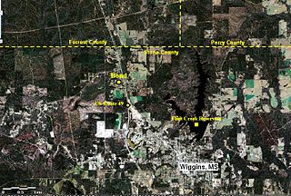
Bond is a census-designated place and unincorporated community in northern Stone County, Mississippi, United States. The community is situated approximately 3 miles (4.8 km) north of Wiggins on U.S. Route 49, and is part of the Gulfport-Biloxi metropolitan area. It was first named as a CDP in the 2020 Census which listed a population of 506.

Bastian is an unincorporated community and census-designated place (CDP) in Bland County, Virginia, United States. Bastian is 4 miles (6 km) north-northwest of Bland. It was first listed as a CDP in the 2020 census with a population of 343. Bastian has a post office with ZIP code 24314.
Chapman is an unincorporated community in Butler County, Alabama, United States. Chapman is located on County Route 37, 2.9 miles (4.7 km) west-northwest of Georgiana. Chapman has a post office with ZIP code 36015.
Leaf is a census-designated place and unincorporated community in Greene County, Mississippi, United States.
Manning is a ghost town in Angelina County, Texas in East Texas. It is located within the Lufkin, Texas micropolitan area.
Manistee is an unincorporated community in Monroe County, Alabama, United States. Manistee was a logging town, and was home to the Manistee Mill Company, Bear Creek Mill Company and Runyan-Burgoyne Lumber Company. The Manistee Mill Company built a spur track to connect the sawmills of Manistee with the Louisville & Nashville Railroad in Repton and named it the Manistee & Repton Railway. The railway began operations in 1907 and remained in use until the 1970s, operating over 45 miles of track. Amasa Coleman Lee, father of Harper Lee, served as financial manager for a Monroeville law firm's interests in the Manistee & Repton Railway. A post office was operated in Manistee from 1892 to 1912.
Ruthven is a ghost town in Wilcox County, Alabama. Ruthven is named in honor of Ruthven, a division of Lincolnshire. It was formerly a lumber town in the early 20th century, and was incorporated in 1924. It was located about 3 1/2 miles southwest of Pine Apple on Bear Creek along the Selma to Flomaton branch of the Louisville & Nashville Railroad, what is now County Road 2. In 1930, it had 523 residents, making it the second largest town in Wilcox County after the county seat of Camden. Shortly afterwards, the town either disincorporated or lost its charter and rapidly declined. Very little exists of the town today as most of its buildings were dismantled. A post office was also located at Ruthven for a time.
Hybart is an unincorporated community in Monroe County, in the U.S. state of Alabama. Hybart is located at 31°49′36″N87°22′56″W. It is located at the intersection of Alabama State Route 41 and Monroe County Road 56, in the northwestern part of Monroe County, just a short distance from its border with Wilcox County, Alabama. Hybart is the host of a locally famous Alabama turkey hunting competition called the Butterball which has appeared in Mobile Bay Magazine. The area is also known for being a good hunting spot for whitetail deer, turkey, quail, dove, and duck. Hybart is on the northwestern edge of the Red Hills region of southwestern Alabama, a hilly, wooded, and still largely undeveloped part of the state, geologically distinct from the Gulf Coastal Plain to its south, and the Black Belt region to its north. Within the Red Hills region, the Forever Wild Land Trust of Alabama owns two large tracts of land a few miles to the southeast of Hybart. Recreational opportunities in these tracts include hunting, woods road hiking/exploration, wildflower viewing, photography, and bird and wildlife watching. The Red Hills tracts are open to visitors year-round.


