Butler County is a county located in the south central portion of the U.S. state of Alabama. As of the 2020 census, the population was 19,051. Its county seat is Greenville. Its name is in honor of Captain William Butler, who was born in Virginia and fought in the Creek War, and who was killed in May 1818.

Clarke County is a county located in the southwestern part of the U.S. state of Alabama. As of the 2020 census, the population was 23,087. The county seat is Grove Hill. The county's largest city is Jackson. The county was created by the legislature of the Mississippi Territory in 1812. It is named in honor of General John Clarke of Georgia, who was later elected governor of that state.
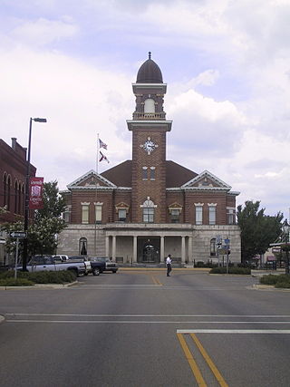
Colbert County is a county located in the northwestern part of the U.S. state of Alabama. As of the 2020 census the county's population was 57,227. The county seat is Tuscumbia. The largest city is Muscle Shoals.

Escambia County is a county located in the south central portion of the U.S. state of Alabama. As of the 2020 census, the population was 36,757. Its county seat is Brewton.

Marengo County is a county located in the west central portion of the U.S. state of Alabama. As of the 2020 census, the population was 19,323. The largest city is Demopolis, and the county seat is Linden. It is named in honor of the Battle of Marengo near Turin, Italy, where French leader Napoleon Bonaparte defeated the Austrians on June 14, 1800.

Marion County is a county of the U.S. state of Alabama. As of the 2020 census the population was 29,341. The county seat is Hamilton. The county was created by an act of the Alabama Territorial General Assembly on February 13, 1818. The county seat was originally established in Pikeville in 1820, and moved to Hamilton in 1881. The county was named by planter and US Indian agent John Dabney Terrell, Sr., in recognition of General Francis Marion of South Carolina.

Monroe County is a county located in the southwestern part of the U.S. state of Alabama. As of the 2020 census, the population was 19,772. Its county seat is Monroeville. Its name is in honor of James Monroe, fifth President of the United States. It is a dry county, in which the sale of alcoholic beverages is restricted or prohibited, but Frisco City and Monroeville are wet cities.

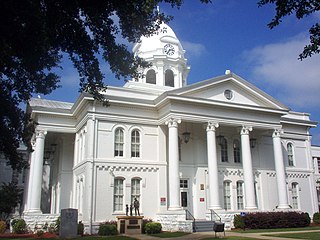
Wilcox County is a county of the U.S. state of Alabama. As of the 2020 census, the population was 10,600. Its county seat is Camden.

Brewton is a city in and the county seat of Escambia County, Alabama, United States. As of the 2020 census, the population was 5,276. Brewton is located in south central Alabama, just north of the Florida Panhandle.

Monroeville is the county seat of Monroe County, Alabama, United States. At the 2020 census its population was 5,951.
Furman, also known as Old Snow Hill, is an unincorporated community in Wilcox County, Alabama, United States. The Furman Historic District is included on the National Register of Historic Places.

Pleasant Hill is an unincorporated community in Dallas County, Alabama.
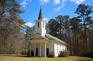
Tunnel Springs is an unincorporated community in Monroe County, Alabama, United States. It has one site listed on the Alabama Register of Landmarks and Heritage, the Old Scotland Presbyterian Church.

Chunchula is an unincorporated community and census-designated place (CDP) in Mobile County, Alabama, United States. As of the 2020 census, its population was 195. It has a post office with the 36521 ZIP code. The community has one site listed on the Alabama Register of Landmarks and Heritage, the Chunchula School.

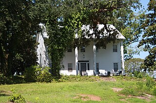
Claiborne is a ghost town on a bluff above the Alabama River in Monroe County, Alabama.

Suggsville is an unincorporated community in Clarke County, Alabama.
Bladon Springs is an unincorporated community in Choctaw County, Alabama, United States. The community grew up around and gained its name from the mineral springs that once were operated as a renowned hotel and spa, now within the modern Bladon Springs State Park. The community itself featured many ornate homes and cottages built as summer residences by people from other parts of the state and elsewhere. Much of the community is part of the Bladon Springs Historic District, listed on the Alabama Register of Landmarks and Heritage on April 1, 1976.
Pushmataha is an unincorporated community in Choctaw County, Alabama, United States. It was named in honor of famed Choctaw chief Pushmataha. Much of the community is part of the Pushmataha Historic District, listed on the Alabama Register of Landmarks and Heritage in October 2008.
Nadawah is a ghost town in Monroe County, Alabama.
Hybart is an unincorporated community in Monroe County, in the U.S. state of Alabama. Hybart is located at 31°49′36″N87°22′56″W. It is located at the intersection of Alabama State Route 41 and Monroe County Road 56, in the northwestern part of Monroe County, just a short distance from its border with Wilcox County, Alabama. Hybart is the host of a locally famous Alabama turkey hunting competition called the Butterball which has appeared in Mobile Bay Magazine. The area is also known for being a good hunting spot for whitetail deer, turkey, quail, dove, and duck. Hybart is on the northwestern edge of the Red Hills region of southwestern Alabama, a hilly, wooded, and still largely undeveloped part of the state, geologically distinct from the Gulf Coastal Plain to its south, and the Black Belt region to its north. Within the Red Hills region, the Forever Wild Land Trust of Alabama owns two large tracts of land a few miles to the southeast of Hybart. Recreational opportunities in these tracts include hunting, woods road hiking/exploration, wildflower viewing, photography, and bird and wildlife watching. The Red Hills tracts are open to visitors year-round.


