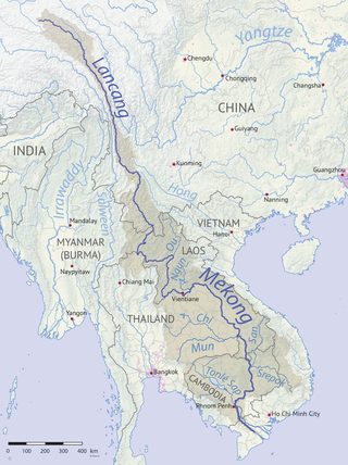
Nam Ngum Dam

Last updated
Nam Ngum Dam
Laos location map Topographic.png
Red pog.svg
Location of Nam Ngum Dam in Laos
Location Vientiane Capital, Laos
Coordinates 18°31′51″N102°32′51″E / 18.53083°N 102.54750°E / 18.53083; 102.54750 Coordinates: 18°31′51″N102°32′51″E / 18.53083°N 102.54750°E / 18.53083; 102.54750
Construction began1968
Opening date1971
Construction costUS$97 million (over three phases)
Owner(s) EDL
Dam and spillways
Type of dam Gravity dam
Impounds Nam Ngum River
Height70 m (230 ft)
Length468 m (1,535 ft)
Spillway typeRadial
Reservoir
CreatesAng Nam Ngum
Total capacity4.7 km3 (3,800,000 acre⋅ft)
Catchment area 8,460 km2 (3,266 sq mi)
Surface area370 km2 (140 sq mi)
Power Station
Operator(s) EDL-GEN
Commission date1971
Hydraulic head 45.5 m (149 ft)
Turbines 2 x 17.5 MW Francis
3 x 40 MW Francis
Installed capacity 155 MW
Annual generation 865 GW

The Nam Ngum Dam is a hydroelectric dam on the Nam Ngum River, a major tributary of the Mekong River in Laos. It was the first hydropower dam built in the Lao PDR.

Contents

Construction

The dam was constructed in three stages, beginning in with stage I in 1968 and ending with the completion of stage III in 1984. The Mekong River Commission first implemented the dam project as part of the national development plan. The project was mainly focused on harnessing Lao PDR's hydropower potential, but it has also striven to achieve flood protection, implement lift irrigation, facilitate lake fisheries, and develop Lao PDR's tourism industry. The Nam Ngum Dam has a capacity of 155 MW and generates most of Laos' electricity, including all the power used in the capital, Vientiane. Additionally 70–80 percent of electricity created by the dam is exported to Thailand. The revenue from export accounts for about a quarter of Laos' foreign exchange earnings. The gross power revenues of the dam are approximately US$36 million annually. Recent studies have indicated that the dam has adversely affected lake fishery and the Nam Ngum River ecosystem. Responsibility for operation of the project rests with the national power utility Electricité du Laos, a state enterprise under the Ministry of Industry and Handicraft. [1]

Today, the Lao PDR's hydropower potential is widely recognized as one of the country's main resources, since it enjoys a strategic location between the booming economies of China, Vietnam, and Thailand and rivers that contribute 35 percent of Mekong flows. The Lao PDR has an estimated potential of some 18,000 MW from over 60 project sites on the tributaries of the Mekong River, of which less than 3 percent has been developed. [2]

Location

The Nam Ngum River originates in Phou Kout in the northeastern part of the Tran Ninh Plateau, through which the river flows southwestward, and discharges into the Mekong River 55 kilometers east of Vientiane. Covering seven percent of the nation's land area, the Nam Ngum basin is home to roughly 500,000 people, representing approximately nine percent of the Lao PDR's population. The length of the river is 420 kilometers. The Nam Ngum project is 60 kilometers north of Vientiane on the Nam Ngum tributary of the Mekong, within the Vientiane Capital Province. [2] The Nam Ngum catchment covers 8,460 km2 (3,266 sq mi), and is on track to becoming one of the most heavily dammed catchments in Laos, with six additional dams at various stages of planning and construction, and two water diversions. [2]

Laos LaosCarte.gif
Laos

History

During the 1960s, power production in the Kingdom of Laos was not sufficient to meet national needs. The government had attempted to meet power requirements through small local developments and power loans from Thailand. A feasibility study presented in December 1962 was the first detailed plan outlining the Nam Ngum 1 project. The study explained how the proposed dam could contribute to hydropower generation, flood control, and irrigation. The project was well received by the Lao government and many international organizations, and the plan for construction was finalized in 1968. [1] Three distinct feasibility studies were conducted to outline each stage of the project, and three distinct funds were established to fund all three stages of the Nam Ngum 1 project. Ten countries gave financial aid to pay for its construction. [3] These funds were collected, overseen, and administered by the United Nations and The World Bank. The total cost of the Nam Ngum Dam was US$97 million. [1]

Construction of the Nam Ngum 1 (NN1) Dam

First stage funding (1966)

In 1966 Japan, The United States, the World Bank and the United Nations established the NN1 Fund to finance the first stage of the project. [1]

Planning of Stage I (1968)

In 1968 the Mekong Commission completed their design for Stage I of the NN1 project. [1]

Stage 1 of NN1 project (1968-1971)

The first stage of the project was implemented in by the Mekong-Commission as part of the 1968-1974 Lao Development Plan. Construction began in 1968 and completed in 1971. During the Stage I the dam was given a full supply level of 202.5 elevation, two 15 MW turbine-generator units, and intakes for units 3, 4, and 5. The total cost of Stage I was US$28 million. [1]

Planning of Stage II (1973)

In 1973 the government of Laos issued a feasibility study in order to fully plan of the NN1 project Stage II. [1]

Stage II funding (1974)

In 1974 Laos established the Stage II fund with the help of the World Bank, the United Nations, and the Asian Development Bank. [1]

Stage II of the NN1 project (1976-1980)

Stage II was undertaken from 1976 and completed in 1980. During stage II four spillway gates were installed, the full supply level was raised to 212 m elevation, and two 40 MW turbine-generator units were added to the power output. The total cost of Stage II was US$49 million. [1]

Fishery Development (1978)

After completion of Stage II in 1978 the government of the Lao PDR realized that it had neglected to account for how the dam would affect the Nam Ngum river ecosystem, and the hundreds of thousands of people who relied on fishing for subsistence. As a response to this issue fishery development projects were contributed by Netherlands and Switzerland. This included the construction of primary schools and water supply networks as well as the provision of gill nets and boat engines to selected villages. These projects were intended to facilitate fishery employment in Nam Ngum 1 reservoir. This project facilitated the movement of tens of thousands of local fisherman to the banks of the Nam Ngum reservoir throughout the 1980s and 1990s. [1]

Funding of Stage III (1976)

In 1976 the government established the NN1 Stage III Fund with the help of Japan, the United States, and the Asian Development Bank. [1]

Planning of Stage III (1980)

In 1980 the government of the Lao PDR issued a feasibility study to plan Stage III of the NN1 project. [1]

Stage III of the NN1 project (1983-1984)

Stage III began in 1983 and was completed in 1984. During this final stage a third 40 MW turbine-generator unit was added to the dam. The total cost of Stage III was US$20 million. [1]

Description of the Nam Ngum 1 project

Nam Ngum Dam

Nam Ngum 1 Dam.JPG

Nam Ngum 1 is a gravity concrete dam with a power station at the base of the dam. Currently the Ngum Nam has a total output capacity of 150 megawatts. Nam Ngum 1 is approximately 75 meters tall, with a total area of 400 km2. The effective storage capacity of the dam is 4,700 x 106 m3. [3]

Nam Ngum Reservoir

Nam Ngum+Nam Lik Nam Ngum+Nam Lik.JPG
Nam Ngum+Nam Lik

The Nam Ngum reservoir is the largest body of water in the Lao PDR. The dam also serves as major river regulation infrastructure in the basin and its maximum storage is approximately 8.5 billion m3, with a reservoir surface area of 370 km2, and an available depth of 16 m. In 1996 a diversion from the Nam Song River directly into the Nam Ngam 1 reservoir was completed. The diversion transfers 400 m3/second to increasing hydropower generation. [1]

Ecological Impacts of the Nam Ngum Dam

As rapid economic development continues in Southeast Asia and the lower Mekong basin, demands for both food and energy will continue to rise. The Lao government is also keen to utilize its water resources to pursue irrigation expansion and more hydropower projects. This development is seen as critically important for meeting current and future energy demand in the rapidly growing cities and towns throughout the lower Mekong in Thailand, Vietnam, and Laos. With these rising demands come the challenges of regional management of water resources and increased pressure upon surrounding ecosystems. Within this context, the implications of the Nam Ngam Dam, and other projects like it, are a matter of some controversy. Whether or not hydropower-based economic development is consistent with other socioeconomic and environmental objectives in the Lao PDR (irrigation, fisheries, flood control) has scarcely been explored. [2]

Determining the viability of the dual strategy of irrigation and hydropower expansion requires careful analysis to understand whether the water needed for energy generation objectives could be balanced with the water that would be required for additional irrigation development. The issue is that the dam projects in the Nam Ngum are often independently planned and managed, with only minimal consideration of their cumulative and basin-wide economic and hydrological impacts. The lack of coordination is evident in recent controversies and observed flood damages from poorly managed water releases during high flow events. This is in part due to an insufficient valuation of the country's vast water resources. Revenues from electricity generation at individual dams sometimes overshadow potential trade-offs with other important economic sectors like agriculture and aquaculture, or with the nonmarket value generated by subsistence fisheries and other hydrological services. [2]

Fishing in particular is extremely important to the local economy. Fishing provides the primary source of meat for these villagers, with fish contributing 56.3 percent of protein to the local diet. The average household consumes 83.2 kg fish protein each year compared to the Laos national average of 8–10 kg /year. Among these households, 50 percent supplement family income by selling fish to traders in their villages. In total villagers harvest more than 55 indigenous species from in the Nam Ngum reservoir annually. In recent years the excess harvesting of the Nam Ngum reservoir has greatly reduced the biodiversity of the reservoir, and made fishing more difficult. Many ecologists have criticized the Lao PDR for failing to effectively manage reservoir fishing. Annual fish production in the reservoir from 1979 to 1983 was estimated at 1,472 tons or 37 kg /ha. Since then, harvest rates and productivity have decreased substantially to about 20 kg/ha by 1988, resulting in a total estimated fish production of some 740 tonnes per year. Considering that reliable fish catch assessments are extremely difficult the actual situation may be even worse. Nonetheless, the catch statistics available indicate that the reservoir fishery has progressively shifted from the large-bodied top-predators to small-bodied, low-value planktivores. This trend of fishing down food webs is common in fisheries. The data available evidences the trend of individual fishers experience more total catches, but lesser returns from the small fish harvested. Many researchers examining the problem have suggested giving local villages more control over the regulation of fishing in the reservoir, to facilitate more sustainable fishing practices. [4]

Some reports have also found that the Nam Ngum dam has adversely affected aquatic life downstream. Careful analysis has revealed that water released from the Nam Ngum reservoir has different quality as compared to the water in undammed natural rivers. Specifically the dissolved oxygen levels in the water released from the reservoir are unfavorable for aquatic life most of the year, especially during the wet season. Similarly some reporters have noted an unsafe level of hydrogen sulfide. The dam also actively blocks migration by upland fish into the downstream part of the river, which secludes these fish from active spawning sights. These deteriorations in the water quality and biodiversity of Nam Ngum river, pose a significant risk to the overall river ecosystem. [5]

The Nam Ngum 1 heavily influences local agriculture irrigation. According to the 2005 national census, subsistence-based agriculture is the main form of livelihood generation for the majority of citizens, and 75 percent of the population in basin provinces report agriculture as their primary form of employment. Some government officials and academics have raised concerns about if the water required for hydropower generation could co-exist with the water being used for irrigation expansion. A study from Duke [2] recently used the Nam Ngum dam as a case study to model the effects of current and expanded hydropower usage on the river. The study determined that if high-levels of water availability continue tradeoffs between agricultural and hydropower goals will be modest because with high-levels of water irrigation expansion will not significantly effect hydropower generation or vice versa. However, the study did find that under dry conditions the tradeoff between expanded irrigation and hydropower increases. The study determined that continued hydropower generation and hydropower expansion could become exceedingly difficult in such conditions. This is because future returns from Nam Ngum dam and expanded agriculture are largely dependent on high levels of rainfall and water levels. Accordingly, the expected future economic returns from the Nam Ngum dam as well as agriculture expansion in the Vientiane province would be severely decreased in dry conditions. As a result of the potential impact of dry conditions, there is widespread uncertainty about the future of Nam Ngum 1 and further hydropower project on the Nam Ngum. Some scholars have become concerned that climate change may lead to decreased levels of rainfall. As with fishing in the reservoir, the government of the Lao PDR will likely have to take steps to address hydrology issues in the future. [2]

Related Research Articles

Mekong Major river in Southeast Asia

The Mekong, or Mekong River, is a trans-boundary river in East Asia and Southeast Asia. It is the world's twelfth longest river and the seventh longest in Asia. Its estimated length is 4,350 km (2,703 mi), and it drains an area of 795,000 km2 (307,000 sq mi), discharging 475 km3 (114 cu mi) of water annually. From the Tibetan Plateau the river runs through China, Myanmar, Laos, Thailand, Cambodia, and Vietnam. The extreme seasonal variations in flow and the presence of rapids and waterfalls in the Mekong make navigation difficult. Even so, the river is a major trade route between western China and Southeast Asia.

Mekong River Commission Intergovernmental organization that manages the water resources of the Mekong River

The Mekong River Commission (MRC) is an "...inter-governmental organisation that works directly with the governments of Cambodia, Laos, Thailand, and Vietnam to jointly manage the shared water resources and the sustainable development of the Mekong River". Its mission is "To promote and coordinate sustainable management and development of water and related resources for the countries' mutual benefit and the people's well-being".

Dams and reservoirs in Laos

Dams and reservoirs in Laos are the cornerstone of the Lao government's goal of becoming the "battery of Asia".

Nam Theun 2 Dam Dam in Bolikhamsai and Khammouane Provinces, Laos

The Nam Theun 2 Hydropower Project, or simply NT2, is a hydroelectric dam on the Nam Theun River in Laos. Commercial operation of the plant began in April 2010. The scheme diverts water from the Nam Theun, a tributary of the Mekong River, to the Xe Bang Fai River, enabling a generation capacity of 1,075 MW, from a 350 m (1,148 ft) difference in elevation between the reservoir and the power station.

Nam Ngum River river in Laos

Nam Ngum is a 354 km long river in Laos. It is a major tributary of the Mekong River.

Nam Ou river in Laos

The Nam Ou is one of the most important rivers of Laos. It runs 448 km from Phongsaly Province to Luang Prabang Province. The river rises in Muang Ou Nua,near the Lao-Chinese border and traverses the northern Laos mountains and gorges until meeting the Mekong River in Ban Pak Ou. Along with the Mekong, the Nam Ou is the only natural channel suitable for large-draft boat transportation. The Nam Ou is one of the 12 principal tributaries of the Mekong River. The river has a total area of nearly 26,000 km². Near its confluence with the Mekong are the Pak Ou Caves, famous for their Buddha statues. The river is also surrounded by limestone karts, forests, and valleys. The river supports Lao rice cultivation. The Nam Ou placed in the top 80th percentile for river health according to the Mekong River Commission’s aquatic health index.

Julliens golden carp species of fish

The Jullien's golden carp is a species of endangered freshwater ray-finned fish in the family Cyprinidae found in Southeast Asian river basins. Its existence is being threatened by various economic activities, such as large-scale agriculture and the building of dams for hydropower.

Fishing industry in Laos

The fishing industry in the land-locked country of Laos is a major source of sustenance and food security to its people dwelling near rivers, reservoirs and ponds. Apart from wild capture fisheries, which is a major component of fish production, aquaculture and stocking are significant developments in the country. Historically, fishing activity was recorded in writings on the gate and walls of the Wat Xieng Thong in Luang Prabang dated 1560. For many Laotians, freshwater fish are the principal source of protein. The percentage of people involved in regular fishing activity is very small, only near major rivers or reservoirs, as for most of the fishers it is a part-time activity.

Électricité du Laos

Électricité du Laos(EDL) is the state corporation of Laos that owns and operates the country's electricity generation, electricity transmission and electricity distribution assets. The company also manages the import and export of electricity from the national electricity grid of the country. EDL was founded in 1959 and is headquartered in Vientiane.

Hydropower in the Mekong River Basin

The estimated hydropower potential of the lower Mekong Basin is 30,000 MW, while that of the upper Mekong Basin is 28,930 MW. In the lower Mekong, more than 3,235 MW has been realized via facilities built largely over the past ten years, while projects under construction will represent an additional 3,209 MW. An additional 134 projects are planned for the lower Mekong, which will maximize the river's hydropower generating capacity. The single most significant impact—both now and in the future—on the use of water and its management in the Mekong Region is hydropower.

Sirindhorn Dam Dam in Sirindhorn, Ubon Ratchathani

The Sirindhorn Dam is in Sirindhorn District, Ubon Ratchatani, Thailand. It impounds the Lam Dom Noi River, and its reservoir is the province's largest water resource. The dam was commissioned in 1971 to serve as a hydropower facility as well as to supply irrigation water. The dam was named after Princess Royal Sirindhorn. All of the electricity generated by the dam is destined for domestic markets. The dam was constructed and is owned and operated by the Electricity Generating Authority of Thailand and is located in the Mekong River Basin, just upstream from the controversial Pak Mun Dam.

The Stung Battambang 1 is a dam planned for construction on the Battambang River in Cambodia. The river is a major tributary of the Tonlé Sap. Of the two dams planned for this river, the larger is the Stung Battambang 1. A letter of commitment has been issued by the Cambodian authorities for a pre-feasibility study of the dam by an unknown Korean company

Stung Treng Dam Dam in Stung Treng Province

The Stung Treng Dam is a proposed hydroelectric dam on the Mekong River in Stung Treng Province, Cambodia. It would be located on the mainstream of the Lower Mekong River. The project is controversial for several reasons, including its possible impact on the fisheries, as well as other ecological and environmental factors.

Xayaburi Dam Dam in Xayaburi

The Xayaburi Dam is a run-of-river hydroelectric dam on the Lower Mekong River, approximately 30 kilometres (19 mi) east of Sainyabuli (Xayaburi) town in northern Laos. Commercial operation of the dam started in October 2019. The main purpose of the dam is to produce hydroelectric power, 95% of which is to be purchased by the Electricity Generating Authority of Thailand (EGAT). The project is surrounded in controversy due to complaints from downstream riparians and environmentalists. Preliminary construction began in early-2012, but work on the dam itself was suspended shortly thereafter due to complaints from Cambodia and Vietnam downstream. After making modifications to the dam's design, Laos started construction with a ceremony on 7 November 2012. The Xayaburi Dam is the first of the 11 dams planned on the lower Mekong.

Don Sahong Dam Dam in Champasak Province

The Don Sahong is a hydroelectric dam commissioned in 2020 on the Mekong River in Siphandone area of Champasak Province, Laos, less than two kilometers upstream of the Laos–Cambodia border.

Houay Ho Dam Dam in Attapeu Province, Laos

The Houay Ho is a dam located in the Samakkhixay District of Attapeu Province, Laos, 160 km (99 mi) east of Pakse and 30 km (19 mi) northwest of Attapeu. The project is considered the first privately financed joint venture 'build-operate-transfer' (BOT) hydropower project in Laos. It has installed capacity of 152.1 megawatts (204,000 hp), almost all of which is exported to Thailand.

This page describes energy and electricity production, consumption and import in Laos.

Bolikhamsai Province Province of Laos

Bolikhamsai is a province of Laos. Pakxan, Thaphabat, Pakkading, Borikhane, Viengthong, and Khamkeut are its districts and Pakxan is its capital city. The province is the site of the Nam Theun 2 Dam, the country's largest hydroelectric project.

Water supply and sanitation in Laos

Laos is a nation with plentiful surface water and broad rivers, but outside of cities there is little infrastructure to make that water clean and accessible. Very little improvement has been made since the end of the Laotian Civil War in 1975, especially compared to peer nations such as Thailand. By 2015, 76% of Laotians nationwide were estimated to have access to “improved” water, while 71% were estimated to have access to “improved” sanitation.

Nam Ou river cascade dams

The Nam Ou cascade hydropower project is a series of seven hydroelectric dams along the Nam Ou river which are located in the provinces of Phongsaly and Luang Prabang in northern Laos. The project is managed by the Power Construction Corporation of China (PowerChina) and the Lao government. The project is the series of dams include seven levels of reservoirs in an attempt to mitigate ecological deterioration. The construction of the hydropower project is being completed in two phases. Phase I of the dams, including Nam Ou 2, Nam Ou 5, and Nam Ou 6 began operating on May 12, 2016. Phase II of the dams, including Nam Ou 1, 3, 4, and 7 is expected to be completed in 2020.

References

  1. 1 2 3 4 5 6 7 8 9 10 11 12 13 14 "Case Study: Benefits due to Dam Function – Nam Ngum 1 Hydropower Plant, Lao PDR" (2006). December 2002: 2–5.Cite journal requires |journal= (help)
  2. 1 2 3 4 5 6 7 Bartlett, Ryan (December 2012). "Analyzing Economic Tradeoffs of Water Use in the Nam Ngum River Basin, Lao PDR". Duke Environmental Economics Working Paper Series.
  3. 1 2 "Nam Ngum 1". Lao PDR Department of Energy Business. Retrieved 10 March 2015.
  4. "Nam Ngum Reservoir Fishery". MRCS Environment Training Program Case Studies (10/18/2001): 3–5.
  5. Schouten, Roel (December 1998). "Effects of Dams on Downstream Reservoir Fisheries, Case of Nam Ngum" (PDF). Mekong Fish Catch and Culture. 4 (2): 2–4. Retrieved 16 March 2015.