
Hancock County is the southernmost county of the U.S. state of Mississippi and is named for Founding Father John Hancock. As of the 2020 census, the population was 46,053. Its county seat is Bay St. Louis.

Diamondhead is a city in southeastern Hancock County, Mississippi, United States. The city is located just over 50 miles (80 km) northeast of New Orleans, Louisiana. It is part of the Gulfport−Biloxi Metropolitan Statistical Area. In February 2012, Diamondhead was officially incorporated as a city. In the 2020 USA decennial census, the city population was 9,529.

Kiln is an unincorporated community and census-designated place (CDP) in Hancock County, Mississippi, United States. The town is located about 50 miles (80 km) northeast of New Orleans, Louisiana. It is part of the Gulfport-Biloxi Metropolitan Statistical Area. The population was 2,238 at the 2010 census.

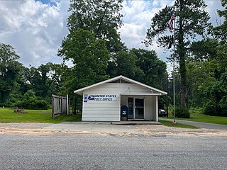
Pearlington is a census-designated place (CDP) in Hancock County, Mississippi, United States, on U.S. Route 90, along the Pearl River, at the Louisiana state line. It is part of the Gulfport–Biloxi, Mississippi Metropolitan Statistical Area. The population was 1,684 at the 2000 census. On August 29, 2005, Hurricane Katrina made landfall just south of Pearlington.

Money is an unincorporated community near Greenwood in Leflore County, Mississippi, United States, in the Mississippi Delta. It has fewer than 100 residents, down from 400 in the early 1950s when a cotton mill operated there. Money is located on a railroad line along the Tallahatchie River, a tributary of the Yazoo River in the eastern part of the Mississippi Delta. The community has ZIP code 38945 in the Greenwood, Mississippi micropolitan area.
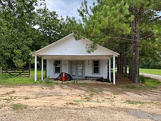
Clermont Harbor is an unincorporated community on the western end of Hancock County on the Gulf Coast of Mississippi. It is part of the Gulfport–Biloxi, Mississippi Metropolitan Statistical Area.

Lauderdale is an unincorporated community and census-designated place (CDP) in Lauderdale County, Mississippi, United States. It is situated along U.S. Highway 45, 16 miles (26 km) northeast of Meridian, the county seat. The population of Lauderdale was 395 at the 2020 census.
Stringer is an unincorporated community in southwestern Jasper County, Mississippi, United States. It lies at the intersections of State Highways 15 and County Road 10, just north of Mississippi State Highway 533, between Bay Springs and Laurel. The population was 1,867 at the 2010 census.

Rena Lara is a census-designated place and unincorporated community located along Mississippi Highway 1 in southwestern Coahoma County, Mississippi, United States. Rena Lara is located on the former Riverside Division of the Yazoo and Mississippi Valley Railroad. Rena Lara was once home to two general stores, two grocery stores, and the Richardson and May Land & Planting Company.
Lamar is a census-designated place and unincorporated community in Benton County, Mississippi, United States. It is located along Mississippi Highway 7 in western Benton County. Lamar has a post office with the ZIP code 38642. The nearly abandoned Mississippi Central Railroad runs through Lamar, and is only used rarely for freight trafficking. Lamar shares its ZIP code with the nearby community of Slayden.
Lakeshore is an unincorporated community on the western end of Hancock County, Mississippi. It is part of the Gulfport–Biloxi, Mississippi Metropolitan Statistical Area.

Franklin is an unincorporated community located in Holmes County, Mississippi. Mississippi Highway 17 passes through Franklin, which is approximately 7 miles (11 km) south of Lexington, the county seat, and approximately 12 miles (19 km) north of the town of Pickens.
Lake Como is an unincorporated community located in Jasper County, Mississippi, United States. Lake Como lies one mile east of Tallahoma Creek.
Vossburg is an unincorporated community in Jasper County, Mississippi, United States. Its ZIP code is 39366.
Garlandville is an unincorporated community in Jasper County, Mississippi, United States. Garlandville is 8.2 miles (13.2 km) south-southeast of Newton along Mississippi Highway 504.
Eulogy is an unincorporated community located in Holmes County, Mississippi, United States.
Logtown, Mississippi is a ghost town located in Hancock County, Mississippi. It is one of several ghost towns situated within the 125,000 acre acoustic buffer zone of NASA's John C. Stennis Space Center. It stood along the banks of the Pearl River and had been the site of a very large sawmill and logging community.
Gainesville is a ghost town located in Hancock County, Mississippi.
Ansley is an unincorporated community in Hancock County, Mississippi, United States. It is located approximately 11 mi (18 km) west of Bay St. Louis.
Point is an unincorporated community in Lauderdale County, Mississippi, United States. Its ZIP code is 39323.


