
Hancock County is the southernmost county of the U.S. state of Mississippi and is named for Founding Father John Hancock. As of the 2010 census, the population was 43,929. Its county seat is Bay St. Louis.

Clinton is a city in, and the county seat of, Clinton County, Iowa, United States. The population was 26,885 as of 2010. Clinton, along with DeWitt, was named in honor of the sixth governor of New York, DeWitt Clinton. Clinton is the principal city of the Clinton Micropolitan Statistical Area, which is coterminous with Clinton County. Clinton was incorporated on January 26, 1857.

Kiln is an unincorporated community and census-designated place (CDP) in Hancock County, Mississippi, United States. The town is located about 50 miles (80 km) northeast of New Orleans, Louisiana. It is part of the Gulfport-Biloxi Metropolitan Statistical Area. The population was 2,238 at the 2010 census.

Pearlington is a census-designated place (CDP) in Hancock County, Mississippi, United States, on U.S. Route 90, along the Pearl River, at the Louisiana state line. It is part of the Gulfport–Biloxi, Mississippi Metropolitan Statistical Area. The population was 1,684 at the 2000 census. On August 29, 2005, Hurricane Katrina made landfall just south of Pearlington.

The St. Croix River is a tributary of the Mississippi River, approximately 169 miles (272 km) long, in the U.S. states of Wisconsin and Minnesota. The lower 125 miles (201 km) of the river form the border between Wisconsin and Minnesota. The river is a National Scenic Riverway under the protection of the National Park Service. A hydroelectric plant at St. Croix Falls supplies power to the Minneapolis–St. Paul metropolitan area.

The John C. Stennis Space Center (SSC) is a NASA rocket testing facility in Hancock County, Mississippi, on the banks of the Pearl River at the Mississippi–Louisiana border. As of 2012, it is NASA's largest rocket engine test facility. There are over 50 local, state, national, international, private, and public companies and agencies using SSC for their rocket testing facilities.

The Chippewa River in Wisconsin flows approximately 183 miles (294 km) through west-central and northwestern Wisconsin. It was once navigable for approximately 50 miles (80 km) of its length, from the Mississippi River, by Durand, northeast to Eau Claire. Its catchment defines a portion of the northern boundary of the Driftless Area. The river is easily accessible for bikers and pleasure seekers via the Chippewa River State Trail which follows the river from Eau Claire to Durand.

Bridal Veil is a virtual ghost town located in Multnomah County, Oregon, United States. It was established in the 1880s during a logging boom by a logging company as it harvested timber on nearby Larch Mountain to be a company mill town around a sawmill. It had a close relationship with the logging town of Palmer for the first 50 years of its history. As of November 2011, all that remains of the town is a post office and a cemetery. The site is located near the west end of the Columbia River Gorge.
Austin is an unincorporated community, considered a ghost town, in Grant County, Oregon, United States. It is located north of Oregon Route 7, near the Middle Fork John Day River in the Malheur National Forest.
Interstate 10 (I-10), a major east–west Interstate Highway in the southern areas of the United States, has a section of about 77 miles (124 km) in Mississippi.
Shelldrake is a ghost town in Whitefish Township, Chippewa County, Michigan, United States, about 8 miles (13 km) south of Whitefish Point, Michigan at the mouth of the Shelldrake River on Whitefish Bay. It is listed on the Michigan Historic Register. Prior to European settlement it supported a seasonal Native American fishing village. In the 1890s and early 1900s, it was a thriving sawmill town during peak logging years on the Tahquamenon River watershed. By the 1920s repeated fires and the decline of lumbering led to its demise. Today it is a privately owned ghost town with only a few weathered, original buildings.
Nagrom was a town in King County, Washington, United States. A logging company town, Nagrom was located in the Green River watershed between Kanaskat and Lester. The town was built by the Morgan Lumber Company and named after Elmer G. Morgan, the company founder and owner. The site was chosen for its access to timber and suitability to build a sawmill and mill pond. In 1910, Morgan petitioned the Northern Pacific Railway, which operated the rail line out of Puget Sound and up over Stampede Pass, to build a spur into the small town. The railway balked, but Morgan persisted and eventually the railway relented. The spur into town was built in 1911. A post office was established that same year, along with a telephone and telegraph exchange.

Disston is an unincorporated community in Lane County, Oregon, United States, southeast of Cottage Grove where Brice Creek and Layng Creek join to form the Row River. It is about a mile west of the Umpqua National Forest. Its post office opened in 1906 and ran until 1974. Cranston Jones—the first postmaster—was also one of the founders of the first sawmill in Disston and the name of the town came from the famous Disston saws.
The Finkbine-Guild Lumber Company was established to harvest and market the virgin longleaf pine stands of southern Mississippi during the early 20th century. The main sawmills were located in Wiggins and D'Lo, Mississippi. When the local timber supply dwindled, the company tried to utilize redwood trees from California, but that operation failed because of high transportation costs. Other attempts were made at promoting a more diversified use of the cutover timberlands; some ventures were successful while others were not.

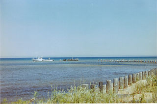
Napoleon is an unincorporated community located on the Pearl River in Hancock County, Mississippi, United States.
Mississippi Highway 607 is a highway in the Mississippi Gulf Coast region. Its southern terminus is at US 90, and it travels westward to Interstate 10 (I-10). The route travels through the Stennis Space Center and to I-59 and US 11 south of Picayune. The road was part of US 11 and US 90, before MS 43 was designated in 1948. MS 607 was created in 1967, after MS 43 was rerouted, and Stennis Space Center was built.
Mississippi Highway 602 was a highway in southern Mississippi. Its southern terminus was at MS 43, which is now inside the John C. Stennis Space Center. The road traveled a slightly curved route to its northern terminus at U.S. Route 11 and MS 43 in Picayune. MS 602 was designated in 1958, only in Pearl River County. The route was extended south into Hancock County two years later. MS 602 was then removed from the state highway system in 1967, less than a decade after it was designated.
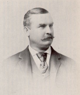
Charles Waterhouse Goodyear was an American lawyer, businessman, lumberman, and member of the prominent Goodyear family of New York. Based in Buffalo, New York, along with his brother, Frank, Charles was the founder and president of several companies, including the Buffalo and Susquehanna Railroad, Great Southern Lumber Company, Goodyear Lumber Co., Buffalo & Susquehanna Coal and Coke Co., and the New Orleans Great Northern Railroad Company.
Gainesville is a ghost town located in Hancock County, Mississippi.

