Narasapuram mandal | |
---|---|
Narasapuram Municipality map | |
Coordinates: 16°26′10″N81°42′06″E / 16.4361°N 81.7016°E Coordinates: 16°26′10″N81°42′06″E / 16.4361°N 81.7016°E | |
Country | India |
State | Andhra Pradesh |
District | West Godavari |
Headquarters | Narasapuram |
Government | |
• Body | Mandal Parishad |
Area | |
• Total | 153.65 km2 (59.32 sq mi) |
Elevation | 15 m (49 ft) |
Population (2011) [1] | |
• Total | 138,741 |
• Density | 900/km2 (2,300/sq mi) |
Languages | |
• Official | Telugu |
Time zone | UTC+5:30 (IST) |
Vehicle registration | AP 37 |
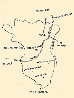
Narasapuram Mandal is one of the 46 mandals in the West Godavari district of the Indian state of Andhra Pradesh. [2] Its headquarters are in Narasapuram, a town in the mandal. The mandal is bordered by the Godavari River to the north, the Bay of Bengal to the east, the Mogalthur mandal to the south, and the Palacole mandal to the west. [3]
West Godavari district or Paschima Godavari Jilla is one of the 13 districts in the Indian state of Andhra Pradesh. The district is situated in Coastal Andhra region of the state. The administrative headquarters of the district is situated at Eluru. As of 2011 census of India, the district has an area of 7,742 km2 (2,989 sq mi) and a population of 3,936,966. It is bounded by Krishna district on the west, East Godavari district on the east, Bay of Bengal on the south and the state of Telangana on the north.
India is a country in South Asia. It is the seventh-largest country by area, the second-most populous country, and the most populous democracy in the world. Bounded by the Indian Ocean on the south, the Arabian Sea on the southwest, and the Bay of Bengal on the southeast, it shares land borders with Pakistan to the west; China, Nepal, and Bhutan to the north; and Bangladesh and Myanmar to the east. In the Indian Ocean, India is in the vicinity of Sri Lanka and the Maldives; its Andaman and Nicobar Islands share a maritime border with Thailand and Indonesia.
Andhra Pradesh is one of the 29 states of India. Situated in the south-east of the country, it is the seventh-largest state in India, covering an area of 160,205 km2 (61,855 sq mi). As per the 2011 census, it is the tenth-most populous state, with 49,386,799 inhabitants. The largest city in Andhra Pradesh is Visakhapatnam. Telugu, one of the classical languages of India, is the major and official language of Andhra Pradesh.
As of the 2011 census, the mandal has a population of 138,741, in 21,606 households. There are 69,405 males and 69,336 females, for a ratio of 999 females per 1000 males. [4] There are 12,605 children aged 6 years and under, of which 6,541 are boys, and 6,064 are girls, for a sex ratio of 927 to 1000. The average literacy rate is 78.83%, with 99,438 literate persons, of which 52,094 are males and 47,344 are females.
The decennial Census of India has been conducted 15 times, as of 2011. While it has been undertaken every 10 years, beginning in 1872, the first complete census was taken in 1881. Post 1949, it has been conducted by the Registrar General and Census Commissioner of India under the Ministry of Home Affairs, Government of India. All the censuses since 1951 were conducted under the 1948 Census of India Act. The last census was held in 2011. The next will be held in 2021. Also it was 1st conducted at the time of industrial revolutions too
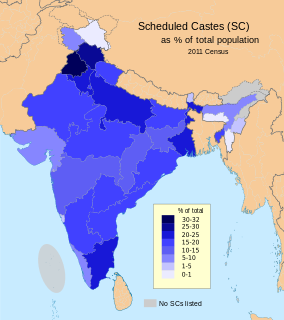
The majority are Schedule Castes with a population of 23,507, whereas Schedule Tribes have a population of 1,480. [5]
The Scheduled Castes (SCs) and Scheduled Tribes (STs) are officially designated groups of historically disadvantaged people in India. The terms are recognised in the Constitution of India and the groups are designated in one or other of the categories. For much of the period of British rule in the Indian subcontinent, they were known as the Depressed Classes.
As of 2011, 59,306 people were engaged in work activities. According to the 2011 census, 46,296 workers work in main work (defined as "employment or earning more than 6 months" which is compared to marginal, or seasonal work), 3,860 work as cultivators, 18,797 work as agricultural labourers, 707 work in the household industry and 22,932 are involved in other jobs. Of these, 13,010 are marginal workers. [1]
Narasapuram mandal is administered under the Narasapuram assembly constituency [6] of the Narsapuram (Lok Sabha constituency) [7] and is one of the 12 mandals that falls under the Narasapuram revenue division.
Narasapuram Assembly constituency is a constituency in West Godavari district of Andhra Pradesh, representing the state legislative assembly in India. It is one of the seven assembly segments of Narasapuram, along with Achanta, Palakollu, Bhimavaram, Undi, Tanuku and Tadepalligudem. Mudunuri Prasada Raju is the present MLA of the constituency, who won the 2019 Andhra Pradesh Legislative Assembly election from YSR Congress Party. As of 25 March 2019, there a total of 168,122 electors in the constituency.
Narasapuram revenue division is an administrative division in the West Godavari district of the Indian state of Andhra Pradesh. It is one of the 4 revenue divisions in the district which consists of 12 mandals under its administration. Narasapuram is the divisional headquarters of the division.
Template:As of the census, the mandal has 16 settlements, all of which are villages. Narasapuram is the largest and Chinamamidipalle is the smallest village by population. [8]
The settlements in the mandal are as follows.
Note: M-Municipality [9]
The mandal plays a major role in education for the rural students of the nearby villages. Primary and secondary school education is imparted by government and private schools, under the School Education Department of the state. [10] For the academic year 2015–16, the mandal had more than 19,585 students enrolled in over 169 schools. [11] [12]
Bhimavaram mandal is one of the 46 mandals in West Godavari district of the Indian state of Andhra Pradesh. It has headquarters at Bhimavaram town. The mandal is bounded by Undi mandal, Palcoderu mandal, Veeravasaram mandal, Narasapuram mandal, Mogalthur mandal and Kalla mandal mandals.
Biccavolu mandal is one of the 65 mandals in East Godavari district of the Indian state of Andhra Pradesh. It is under the administration of Rajahmundry revenue division and the headquarters are located at Biccavolu village. Biccavolu Mandal is bounded by Rayavaram Mandal towards South, Pedapudi Mandal towards East, Anaparthy Mandal towards west, Ramachandrapuram Mandal towards north. It is located ata distance of 41 kilometres from Rajahhmundry.
Lingapalem Mandal is one of 46 mandals in the West Godavari district of Andhra Pradesh in India. Its headquarters are located in Lingapalem. It is bordered by T.Narasapuram and Chintalapudi in the North, Khammam district tin the West, Kamavarapukota mandal in the East, and Pedavegi mandal in the South.
Unguturu mandal is one of 46 mandals in the West Godavari district of the Indian state of Andhra Pradesh. The headquarters are located at Unguturu town. The mandal is bordered by Tadepalligudem mandal and Pentapadu mandal to the north, Nallajerla mandal to the west, Nidamarru mandal to the east, and by Dwaraka Tirumala mandal and Bhimadole mandal to the south
Pentapadu mandal is one of 46 mandals in the West Godavari district of the Indian state of Andhra Pradesh.
Akividu mandal is one of the 46 mandals in West Godavari district of the Indian state of Andhra Pradesh. The headquarters is located at Akividu town. The mandal is bordered by Nidamarru mandal to the west, Krishna district to the south, Tanuku and Undi mandal to the north and Kalla mandal to the east.
T. Narasapuram Mandal is one of the 46 mandals in West Godavari district of the Indian state of Andhra Pradesh. The headquarters are located in T. Narasapuram town. The mandal is bordered by Jangareddygudem Mandal and Jeelugumilli to the north, Kamavarapukota Mandal to the east, Chintalapudi Mandal to the south and Khammam district to the west.
Undi mandal is one of the 46 mandals in West Godavari district of the Indian state of Andhra Pradesh. The headquarters are located in Undi town. The mandal is bordered by Palacoderu mandal to the north, Kalla mandal to the east, Akividu mandal to the south, and Nidamarru to the west.
Kalla Mandal is one of the 46 mandals in West Godavari district of the Indian state of Andhra Pradesh. The headquarters are located at Kalla town. Kalla Mandal is bordered by Bhimavaram Mandal to both north and east, Krishna district to the south, Akividu Mandal and Undi Mandal to the west.
Palacoderu mandal is one of the 46 mandals in the West Godavari district of the Indian state of Andhra Pradesh. The headquarters are located at Palacoderu town. The mandal is bordered by Veeravasam mandal to the north, Bhimavaram mandal to the east, Undi mandal to the south and Attili mandal to the west.
Veeravasaram Mandal is a Mandal in the West Godavari District of the Indian state of Andhra Pradesh.
Palakollu mandal is one of the 46 mandals in the West Godavari district of the Indian state of Andhra Pradesh. The headquarters is located at Palakollu City. The mandal is bordered by Yelamanchili mandal in the north, Narasapuram mandal in the east, Poduru mandal in the south and Veeravasaram mandal in the west.
Yelamanchili mandal is amongst the 46 mandals in West Godavari district of the state of Andhra Pradesh in India. Its headquarters are located in the town of Yelamanchili. The mandal is bordered by the Godavari River to the north and east, the Palacole mandal to the south, and the Poduru and Achanta mandals to the west.
Iragavaram Mandal is one of the 46 mandals in the West Godavari district of the Indian state of Andhra Pradesh. The headquarters are located at Iragavaram town. The mandal is bordered by Peravali mandal and Penugonda mandal to the north, Penumantra mandal to the east, Attili mandal to the south, and Tanuku mandal to the west.
Penumantra Mandal is one of the 46 mandals in the West Godavari district of the Indian state of Andhra Pradesh. Its headquarters arevin Penumantra.
Achanta Mandal is one of the 46 mandals in West Godavari district of the Indian state of Andhra Pradesh. Its headquarters are located in Achanta. The mandal is bordered by Godavari river to the north, Yelamanchili mandal to the east, Poduru mandal to the south, and Penugonda mandal to the west.
Poduru mandal is one of 46 mandals in West Godavari district of the Indian state of Andhra Pradesh. The headquarters is located in the town of Poduru.
Penugonda mandal is one of the 46 mandals in West Godavari district of the Indian state of Andhra Pradesh. The headquarters are located at Penugonda town. The mandal is bordered by Godavari river to north, Achanta mandal to the east, Penumantra mandal and Iragavaram mandal to the south and Peravali mandal to the west.
Attili mandal is one of the 46 mandals in West Godavari district of the Indian state of Andhra Pradesh. The headquarters are located in the town Attili. The mandal is bordered by Iragavaram mandal and Penumantra mandal to the north, Palacoderu mandal to the east, Ganapavaram mandal and Tanuku mandal to the west.
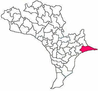
Kruthivennu mandal is one of the 50 mandals in Krishna district of the Indian state in Andhra Pradesh. The headquarters of this mandal is located in the town of Kruthivennu. The mandal is bordered by Kalidindi mandal to the north, West Godavari district to the east, Bay of Bengal to the south and Bantumilli mandal to the west.