Narasapuram, West Godavari district

Last updated

Narasapuram
Location map India Andhra Pradesh EN.svg
Red pog.svg
Narasapuram
Location in Andhra Pradesh, India
Coordinates: 16°26′10″N81°42′06″E / 16.4361°N 81.7016°E / 16.4361; 81.7016 Coordinates: 16°26′10″N81°42′06″E / 16.4361°N 81.7016°E / 16.4361; 81.7016
Country India
State Andhra Pradesh
District West Godavari
Revenue division Narasapuram
Mandal Narasapuram
Named for Lord Narasimha
Government
[1]
  Type Municipal council
  BodyNarasapuram Municipality
   Municipal Commissioner D.Ramesh
   Municipal Chairperson Pasupuleti Ratnamala
   MLA Mudunuri Prasada Raju
   MP Kanumuri Raghurama Krishnam Raju
Area
[2]
  Total11.32 km2 (4.37 sq mi)
Elevation
[3]
2 m (7 ft)
Population
 (2011) [4]
  Total58,770
  Density5,200/km2 (13,000/sq mi)
Languages
  Official Telugu
Time zone UTC+5:30 (IST)
PIN
534275
Telephone code 08814
Vehicle registration AP-37

Narasapuram (or Narsapur) is a town in West Godavari district of the Indian state of Andhra Pradesh. [5] It is a municipality and mandal headquarters of Narasapuram mandal in Narasapuram revenue division. [2] [6] The town is situated on the banks of the Vasista Godavari River. [7] [8] The lace industry is prevalent in the city and its surroundings. [9] [10]

Contents

Etymology

Narsapur was also known as "Nrusimhapuri", named after the Lord Narasimha. [11] Gradually it changed into Narasimhapuram and now to Narasapuram.[ citation needed ]

History

The existence of Narsapur dates back to 1173 AD. Dutch people landed in Narsapur in 1626. Narsapur was used as a port by the Dutch and ships and boats were built here. It was noted for its ship building activity and some of the Europeans also were customers at this place; small boats are still built in Narsapur. In the 16th century, Portuguese established their own factory which remained as a trading centre for a few years. In the 18th century, Narsapur became an important trading port. From this port, teak was exported to other regions. The ports at Kakinada and Narsapuram became famous for manufacturing ships. At present there is no port handling at Narsapur.

Madhavayapalem (Madapallam) is celebrated as one of the earliest places where the English established a factory and was famous for its trade in cloth. According to Alexander Hamilton's A New Account of the East Indies (1727):

"Next to Matchulipatam (Machilipatnam) is Narsipore, where the English had a Factory for long Cloth, for the Use of their Factory of Matchulipatam, when they manufactured Chintz there. It also affords good Teak Timber for building, and has a fine deep River, but a dangerous Bar, which makes it little frequented." [12]

The trade of the town has steadily declined since the abolition of the company's factory in 1827. Before independence, British civilians had made imports and exports from Narsapur.

Geography

Narasapuram municipality in Narasapuram mandal map Narasapuram Municipality in Narasapuram mandal.jpg
Narasapuram municipality in Narasapuram mandal map

Narsapur is located at 16°26′10″N81°42′06″E / 16.4361°N 81.7016°E / 16.4361; 81.7016 and on the right bank of Vasista Godavari River at an altitude of 0 m (0 ft). [3] The River Godavari empties into Bay of Bengal near Antarvedi, at 9.6 km from Narsapur. [6]

Demographics

As of 2011 census, the city had a population of 58,770. The total population is constituted of 28,796 males and 29,974 females – a sex ratio of 961 females per 1000 males, higher than the national average of 940 per 1000. 29,974 children are in the age group of 0–6 years, of which 2,665 are boys and 2,456 are girls. The average literacy rate stands at 86.24% with 46,266 literates, significantly higher than the district average of 73.00%. [4] [13]

Governance

Civic administration

Narasapuram Municipality was constituted in 1956. Narsapur was made a 3rd Grade Municipality in 1956. It was upgraded to 2nd Grade Municipality in 1965 and again upgraded to 1st Grade Municipality in 2001. Narsapur Municipality consists of 31 wards and 48 slums in an area of 11.52 km2. [14]

Politics

Narasapuram is represented by Narasapuram (Assembly constituency) for Andhra Pradesh Legislative Assembly. Under Narasapuram mandal, the town falls in Narasapuram (Lok Sabha constituency). Mudunuri Prasada Raju is the present MLA of the constituency from [[YSRC Party] and the present MP is Kanumuri Raghurama Krishnam Raju from [[YSRCP ]. [15]

Economy

Industries

FishBoat Dawn @ Godavari.JPG
FishBoat

Handmade crochet lace-work is one of the most common form of industry in the town. [16]

There are many industries in and around the town such as International Lace Trade Centre, [17] Oil and Natural Gas Corporation of India, [18] Central Industrial Security Force, [19] Central Marine Fisheries Research Institute, [20] PanGodavari (Handicrafts), [21] Comprehensive Handicrafts Cluster Development Scheme, AWS (Automatic Weather Station) installed and commissioned by IMD. [22]

Aquaculture

Fishery is one of the main occupations that generates good amounts of revenues for the fishermen. It involves cultivation of a variety of estuarine fish called Pulasa. [23]

Culture

Godavari Pushkaram is celebrated every twelve years in Narasapuram to take a holy dip in the Vasista Godavari River. [24] This river is said to have been brought in by the famous Maharishi Vashishtha, one of the seven great sages of the Hindu Mythology. The place draws people from the world over throughout the year. Antarvedi, the merging of the Bay of Bengal and Vasista River, which is a tributary of the River Godavari. The place of confluence of the ocean and river is called the "Sapta Sagara Sangam Pradesam". It is also known as the Anna Chelli Gattu (meaning brother–sister embankment). [25]

Religious destinations

Altar view Narsapurlutheranchurchinsidealtar.png
Altar view

Some of the religious destinations in the town are, Adikesava Emberumaanar Temple, a Vaishnavite temple of 300 years old which was constructed by translator of the British East India Company, Prasannagresara Puppala Ramanappa Naidu; [26] Christ Lutheran Church is in the Andhra Evangelical Lutheran Church and a member church of West Godavari synod. [27]

Landmarks

The Perupalem Beach is located at a distance of 20 km from the town. [28]

Education

The primary and secondary school education is imparted by government, aided and private schools, under the School Education Department of the state. [29] [30] The mediums of instruction followed by different schools are English and Telugu.

Taylor High School is one of the major landmarks in Narsapuram showcasing the Dutch and the British buildings. The high school was founded by British Educationist and local Revenue Officer H. Taylor in 1852, and was later named after him. [31] The 'manyam veerudu' (jungle hero) Alluri Sitarama Raju had his schooling in this institution before he led the Rampa rebellion against the British. [32] Chilakamarti Lakshmi Narasimham, a freedom fighter and a noted Telugu litterateur also attended the school. [33]

Swarnandhra College of Engineering and Technology, an affiliation to Jawaharlal Nehru Technological University of Kakinada, [34] Sri Yerramilli Narayanamurthy college which was established in 1949 are some of the other professional colleges. [35]

Transport

Narsapur Railway Station Narsapur2.jpg
Narsapur Railway Station

Roadways

The town has a total road length of 79.67 km (49.50 mi). [36] The Andhra Pradesh State Road Transport Corporation operates bus services from Narasapuram bus station. [37] National Highway 216 connects NH 16 near Ongole, a short route for Kolkata   Chennai route.

Railways

Narasapuram railway station is a terminal station located on the Bhimavaram–Narasapuram branch line of Vijayawada-Nidadavolu loop line in Vijayawada railway division of South Central Railway zone. It is classified as a B–category station in the Vijayawada railway division of the South Central Railway zone. [38] Kotipalli-Narsapuram railway line is the important railway project to the town.

Waterways

Narasapur Port is proposed for developing it as a minor port, fishing harbor and ONGC Jetty. [39]

Airways

Rajahmundry Airport is the nearest airport to the town which is 80km away from the town.

Sports

Narsapuram Football Club is part of FLOW (Football League Of West Godavari). [40] National level Kabaddi competitions are held every year on the eve of Sankranti festival at Kabadi Stadium, Narsapur. All India level Seniors Tennis Tournament is held in Narsapur officers club every year.

See also

Related Research Articles

Coastal Andhra Region of Andhra Pradesh in India

Coastal Andhra, is a region in the state of Andhra Pradesh, India. This region was part of Madras State before 1953 and Andhra State from 1953 to 1956. According to the 2011 census, it has an area of 95,442 square kilometres (36,850 sq mi) which is 57.99% of the total state area and a population of 34,193,868 which is 69.20% of Andhra Pradesh state population. This area includes the coastal districts of Andhra Pradesh on the Coromandel Coast between the Eastern Ghats and the Bay of Bengal, from the northern border with Odisha to Pulicat lake of South.

Rajahmundry City in Andhra Pradesh, India

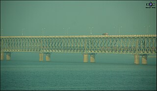
Rajahmundry, officially known as Rajamahendravaram, is a city located in East Godavari district in the Indian state of Andhra Pradesh. The city is located on the banks of Godavari River. In the Madras Presidency, the District of Rajahmundry was created in 1823. It was reorganised in 1859 and was bifurcated into Godavari and Krishna districts. During British rule, Rajahmundry was the headquarters of Godavari District, which was further bifurcated into East Godavari and West Godavari districts in 1925. When the Godavari District was bifurcated, Kakinada became the headquarters of East Godavari and Eluru became headquarters of West Godavari. It is administered under Rajahmundry revenue division. The city is known for its Floriculture, History, Culture, Agriculture, Economy, Tourism, Industrial potential and its Heritage. It is known as the Cultural Capital of Andhra Pradesh.

West Godavari district District of Andhra Pradesh in India

West Godavari district or Paschima Godavari Jilla is one of the 13 districts in the Indian state of Andhra Pradesh. The district is situated in Coastal Andhra region of the state. The administrative headquarters of the district is situated at Eluru. As of 2011 census of India, the district has an area of 7,742 km2 (2,989 sq mi) and a population of 3,936,966. It is bounded by Krishna district on the west, East Godavari district on the east, Bay of Bengal on the south and the state of Telangana on the north.

Machilipatnam City in Andhra Pradesh, India

Machilipatnam, also known as Masulipatnam and Bandar, is a city in Krishna district of the Indian state of Andhra Pradesh. It is a municipal corporation and the administrative headquarters of Krishna district. It is also the mandal headquarters of Machilipatnam mandal in Machilipatnam revenue division of the district. The ancient port town served as the settlement of European traders from the 16th century, and it was a major trading port for the British, Dutch and French in the seventeenth century.

Eluru City in Andhra Pradesh, India

Eluru is a city and the district headquarters of West Godavari district in the Indian state of Andhra Pradesh. It is one of the 14 municipal corporations in the state and the mandal headquarters of Eluru mandal in the Eluru revenue division. The city is on the Tammileru river. The city is well known for its wool-pile carpets and hand woven products. As of 2011 Census of India, the city had a population of 217,876. Its history dates back to the second century CE.

Bhimavaram City in Andhra Pradesh, India

Bhimavaram is a city in West Godavari district of the Andhra Pradesh state of India. It is the administrative headquarters of Bhimavaram mandal in Narasapuram revenue division. It is a part of Eluru Urban Development Authority. As of 2011 census, it is the second most populous city in the district with a population of 142,184. It is one of the major pilgrimage centers in the state, which is home to Somaramam, one of the five great Pancharama Kshetras.

Palakollu Town in Andhra Pradesh, India

Palakollu is the administrative headquarters of Palakollu Mandal in Narasapuram revenue division in West Godavari district of the Indian state of Andhra Pradesh. Palakollu is situated in Coastal Andhra region of the state. It occupies 19.49 square kilometres (7.53 sq mi). As of 2011 census, it has a population of about 61,200 and a Metro population of about 81,199, making it the fourth most populous city in West Godavari District in Andhra Pradesh. It is a part of Eluru Urban Development Authority.

Tanuku Town in Andhra Pradesh, India

Tanuku is a town in West Godavari district of the Indian state of Andhra Pradesh. It is the mandal headquarters of Tanuku mandal in Kovvur revenue division.

Nidadavolu Town in Andhra Pradesh, India

Nidadavolu is a town in West Godavari district of the Indian state of Andhra Pradesh. It is a municipality and the mandal headquarters of Nidadavolu mandal in Kovvur revenue division.

Tuni Town in Andhra Pradesh, India

Tuni is a town in East Godavari district of the Indian state of Andhra Pradesh. It is a major commercial marketing center for more than 40 surrounding villages in the district. Tuni is a border point for the district of East Godavari. It is known for mango export, with nearly 250 varieties. It is also famous for betel leaves and jute bags. A variety of cashew nuts are produced in Tuni.

Narasapur or Narasapuram may refer to places in India:

Mummidivaram Town in Andhra Pradesh, India

Mummidi-varam is a town in East Godavari district of Andhra Pradesh, India. The Mummidivaram revenue block was formed out of the Amalapuram tehsil in July 1969. It is the second largest town in Konaseema.

Swarnandhra College of Engineering & Technology (SCET) was established in 2001 at Narasapuram West Godavari district, Andhra Pradesh, India, by the Vasista Educational Society. Shri. K.V. Satyanarayana is the chairman of the institution.

Narasapuram Mandal Mandal in Andhra Pradesh, India

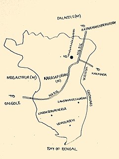
Narasapuram Mandal is one of the 46 mandals in the West Godavari district of the Indian state of Andhra Pradesh. Its headquarters are in Narasapuram, a town in the mandal. The mandal is bordered by the Godavari River to the north, the Bay of Bengal to the east, the Mogalthur mandal to the south, and the Palacole mandal to the west.

T.Narasapuram mandal Mandal in Andhra Pradesh, India

T. Narasapuram Mandal is one of the 46 mandals in West Godavari district of the Indian state of Andhra Pradesh. The headquarters are located in T. Narasapuram town. The mandal is bordered by Jangareddygudem Mandal and Jeelugumilli to the north, Kamavarapukota Mandal to the east, Chintalapudi Mandal to the south and Khammam district to the west.

Undi mandal Mandal in Andhra Pradesh, India

Undi mandal is one of the 46 mandals in West Godavari district of the Indian state of Andhra Pradesh. The headquarters are located in Undi town. The mandal is bordered by Palacoderu mandal to the north, Kalla mandal to the east, Akividu mandal to the south, and Nidamarru to the west.

Veeravasaram mandal Mandal in Andhra Pradesh, India

Veeravasaram Mandal is a Mandal in the West Godavari District of the Indian state of Andhra Pradesh.

Palakollu Mandal Mandal in Andhra Pradesh, India

Palakollu mandal is one of the 46 mandals in the West Godavari district of the Indian state of Andhra Pradesh. The headquarters is located at Palakollu City. The mandal is bordered by Yelamanchili mandal in the north, Narasapuram mandal in the east, Poduru mandal in the south and Veeravasaram mandal in the west.

Achanta mandal Mandal in Andhra Pradesh, India

Achanta Mandal is one of the 46 mandals in West Godavari district of the Indian state of Andhra Pradesh. Its headquarters are located in Achanta. The mandal is bordered by Godavari river to the north, Yelamanchili mandal to the east, Poduru mandal to the south, and Penugonda mandal to the west.

Penugonda mandal Mandal in Andhra Pradesh, India

Penugonda mandal is one of the 46 mandals in West Godavari district of the Indian state of Andhra Pradesh. The headquarters are located at Penugonda town. The mandal is bordered by Godavari river to north, Achanta mandal to the east, Penumantra mandal and Iragavaram mandal to the south and Peravali mandal to the west.

References

  1. "Municipalities, Municipal Corporations & UDAs" (PDF). Directorate of Town and Country Planning. Government of Andhra Pradesh. Archived from the original (PDF) on 5 March 2016. Retrieved 3 December 2015.
  2. 1 2 "District Census Handbook – West Godavari" (PDF). Census of India. pp. 22, 54. Retrieved 22 January 2016.
  3. 1 2 "Maps, Weather, and Airports for Narasapuram, India". fallingrain.com.
  4. 1 2 "Cities having population 1 lakh and above". The Registrar General & Census Commissioner, India. Retrieved 5 April 2015.
  5. "Mandal wise villages" (PDF). Revenue Department – AP Land. National Informatics Center. p. 9. Archived from the original (PDF) on 8 February 2015. Retrieved 10 November 2014.
  6. 1 2 "Guntur District Mandals" (PDF). Census of India. pp. 460, 470. Retrieved 19 January 2015.
  7. Nagaraja, G (10 October 2012). "Narsapur civic body set to get a voice". The Hindu. Narsapur. Retrieved 2 March 2015.
  8. Edgar Thurston (2011). The Madras Presidency with Mysore, Coorg and the Associated States (reissue ed.). Cambridge University Press. p. 25. ISBN   9781107600683 . Retrieved 2 March 2015.
  9. "Handicraft exports jump 44 p.c. in November". The Hindu. New Delhi. 27 December 2009. Retrieved 8 May 2015.
  10. "Godavari Delta Women Lace Artisans Co-Operative Cottage Industrial Society Ltd., – Manufacturers and Exporters of Handmade Cotton Crochet Laces & Processed Cotton Made ups". gdwlace.com.
  11. "Layout page". areaprofiler.gov.in.
  12. Bowrey, Thomas (1895). Temple, Richard Carnac (ed.). A Geographical Account of Countries Round the Bay of Bengal, 1669 to 1679. p. 99.
  13. "Chapter–3 (Literates and Literacy rate)" (PDF). Registrar General and Census Commissioner of India. Retrieved 1 September 2014.
  14. "About Narasapur Municipality | Narasapur Municipal Corporation". narasapur.cdma.ap.gov.in. Retrieved 27 June 2018.
  15. "AP Legislature MLAs". AP State Portal. Archived from the original on 22 October 2014. Retrieved 12 October 2014.
  16. Chari, Pushpa (6 January 2011). "On a creative trip". The Hindu. Retrieved 3 December 2015.
  17. "International lace trade centre to be set up at Narsapuram in AP". The Hindu Business Line. Retrieved 11 October 2015.
  18. "ONGC". godavarimahapushkaram2015. Retrieved 16 May 2015.
  19. "CISF". Cntral Industrial Security Force. Retrieved 16 May 2015.
  20. "CMFRI". Central Marine Fisheries Institute. Retrieved 16 May 2015.
  21. "Pangodavari". pangodavari. Retrieved 16 May 2015.
  22. "List of Automatic Weather Stations (AWS)" (PDF). India Meteorological Department, AWS Lab. Pune, India. Retrieved 16 May 2015.
  23. Murali Sankar, K.N (23 July 2015). "Pulasa fishermen wait for Pushkaram to end". The Hindu. Retrieved 5 February 2016.
  24. Hyland, Paul (1994). Indian balm : travels amongst fakirs and firewarriors. London: TPP. p. 52. ISBN   1845110854 . Retrieved 24 April 2015.
  25. "AP Tourism Blog – Written words last a lifetime!". aptdc.gov.in.
  26. "Sri Adikesava Perumal Brahmotsavams, Narsapur – Antaryami.net Sri Vaishnava Portal". antaryami.net.
  27. "Christ Lutheran Church – Popular Church In Narsapur". indiamapped.com.
  28. Puja Tripathy. "Perupalem Beach". Coastal Tourism India.
  29. "School Education Department" (PDF). School Education Department, Government of Andhra Pradesh. Archived from the original (PDF) on 27 December 2015. Retrieved 7 November 2016.
  30. "The Department of School Education – Official AP State Government Portal | AP State Portal". www.ap.gov.in. Archived from the original on 7 November 2016. Retrieved 7 November 2016.
  31. "A major landmark fallen on bad days". The Hindu. 1 May 2014. Retrieved 24 April 2015.
  32. "Alluri Sita Rama Raju Biography". Baynews. Retrieved 24 April 2015.
  33. Special Correspondent. "A major landmark fallen on bad days". The Hindu.
  34. "Swarnandhra College of Engineering & Technology – Home". www.swarnandhra.ac.in. Retrieved 13 October 2015.
  35. "About us | Shri YN College". www.sriyncollege.org. Retrieved 13 October 2015.
  36. "Details of Roads in each ULB of Andhra Pradesh". Commissioner and Directorate of Municipal Administration. Municipal Administration and Urban Developmemt Department – Government of Andhra Pradesh. Archived from the original on 1 August 2016. Retrieved 28 March 2017.
  37. "Bus Stations in Districts". Andhra Pradesh State Road Transport Corporation. Archived from the original on 22 March 2016. Retrieved 9 March 2016.
  38. "Divisional info" (PDF). Indian Railways . Retrieved 18 July 2015.
  39. "Department of Ports, Andhra Pradesh". apports.in.
  40. "FLOW". www.flow.football. Retrieved 18 February 2016.