Related Research Articles

Andhra Pradesh is a state in the south-eastern coastal region of India. It is the seventh-largest state by area covering an area of 162,975 km2 (62,925 sq mi) and tenth-most populous state with 49,386,799 inhabitants. It is bordered by Telangana to the north-west, Chhattisgarh to the north, Odisha to the north-east, Tamil Nadu to the south, Karnataka to the west and the Bay of Bengal to the east. It has the second longest coastline in India after Gujarat, of about 974 km (605 mi). Andhra Pradesh is the first state to be formed on a linguistic basis in India on 1 October 1953. Andhra Pradesh was once a major Buddhist pilgrimage site in India and a Buddhist learning center which can be seen in many sites in the state in the form of ruins, chaityas and stupas Andhra Pradesh is also known as the land of the world-famous diamond Koh-i-Noor and many other global known diamonds due to their presence in its Kollur Mine once. It is also known as the "rice bowl of India" for being a major producer of rice in India. Its official language is Telugu; one of the classical languages of India, the fourth most spoken language in India and the 11th-most spoken language in the world.

India is a federal union comprising 28 states and 8 union territories, for a total of 36 entities. The states and union territories are further subdivided into districts and smaller administrative divisions.
Krishna district is one of the nine districts in the Coastal Andhra region of the Indian state of Andhra Pradesh. Machilipatnam is the administrative headquarters and Vijayawada is the most populated city in the district. It has an area of 8,727 km2 (3,370 sq mi) and had a population of 4,529,009 as per 2011 census of India. It is bounded by West Godavari on the east, Bay of Bengal on the South, Guntur and Suryapet districts in the west and a portion of it also borders with the state of Telangana.

East Godavari is a district in the Coastal Andhra region of Andhra Pradesh, India. Its district headquarters is at Kakinada. As of Census 2011, it became the most populous district of the state with a population of 5,151,549. Rajahmundry and Kakinada are the major cities in the district in terms of population.

Coastal Andhra is a region in the state of Andhra Pradesh, India. It was part of Madras State before 1953 and Andhra State from 1953 to 1956. According to the 2011 census, it has an area of 95,442 square kilometres (36,850 sq mi) which is 57.99% of the total state area and a population of 34,193,868 which is 69.20% of Andhra Pradesh state population. This area includes the coastal districts of Andhra Pradesh on the Coromandel Coast between the Eastern Ghats and the Bay of Bengal, from the northern border with Odisha to Pulicat lake in the South.

Telangana is a state in India situated on the south-central stretch of the Indian peninsula on the high Deccan Plateau. It is the eleventh-largest state and the twelfth-most populated state in India with a geographical area of 112,077 km2 (43,273 sq mi) and 35,193,978 residents as per 2011 census. On 2 June 2014, the area was separated from the northwestern part of Andhra Pradesh as the newly formed state with Hyderabad as its capital. Its other major cities include Warangal, Nizamabad, Khammam and Karimnagar. Telangana is bordered by the states of Maharashtra to the north, Chhattisgarh to the east, Karnataka to the west, and Andhra Pradesh to the east and south. The terrain of Telangana region consists mostly of hills, mountain ranges, and thick dense forests covering an area of 27,292 km2 (10,538 sq mi). As of 2019, the state of Telangana is divided into 33 districts.

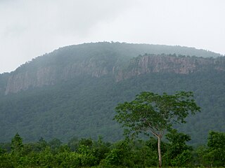
Rayalaseema is a geographic region in the Indian state of Andhra Pradesh. It comprises four southern districts of the state namely, Anantapur, Chittoor, YSR Kadapa and Kurnool. As of 2011 census of India, the region with four districts had a population of 15,184,908 and covers an area of 67,526 km2 (26,072 sq mi).

West Godavari district or Paschima Godavari Jilla is one of the nine districts in the Coastal Andhra region of the Indian state of Andhra Pradesh. The administrative headquarters of the district is situated at Eluru. As of 2011 census of India, the district has an area of 7,742 km2 (2,989 sq mi) and a population of 3,936,966. It is bounded by Krishna district on the west, East Godavari district on the east, Bay of Bengal on the south and the state of Telangana on the north.
Khammam district is a district in the eastern region of the Indian state of Telangana. The city of Khammam is the district headquarters. The district shares boundaries with Suryapet, Mahabubabad, Bhadradri districts and with Andhra pradesh state.
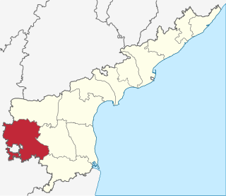
Anantapur district is one of the four districts in the Rayalaseema region of the Indian state of Andhra Pradesh. The district headquarters is located at Anantapur city. As of 2011 census of India, it is the largest district in the state by area and with a population of 4,083,315, it is the eighth most populous district.

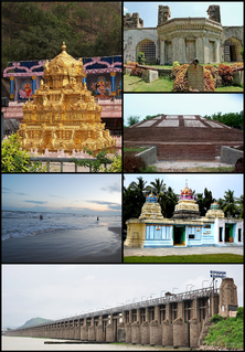
Nellore district, officially Sri Potti Sriramulu Nellore district, is one of the thirteen districts in the Indian state of Andhra Pradesh. According to the 2011 Census, the district's population was 2,966,082, of which 29.07% was urban. Its administrative headquarters are located in Nellore city. Located in the Coastal Andhra region, the district is bordered by the Bay of Bengal to the east, Kadapa district to the west, Prakasam district to the north, and Chittoor district and Thiruvallur district of Tamil Nadu to the south.
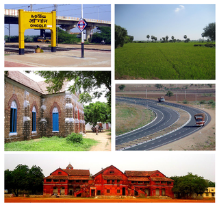
Prakasam district is one of the nine districts in the Coastal Andhra region of the Indian state of Andhra Pradesh. It was formed in 1970. The headquarters of the district is Ongole. It is located on the western shore of Bay of Bengal and is bounded by Guntur district on the north, Kurnool district on the west, Kadapa and Nellore districts on the south. A part of north west region also borders the Mahabubnagar district of Telangana. It is the third-largest district in the state and tenth-largest in the country with an area of 17,626 km2 (6,805 sq mi) and had a population of 3,392,764 as per 2011 census of India.

Sattenapalle is a town in Guntur district of the Indian state of Andhra Pradesh. It is a municipality and the headquarters of Sattenapalle mandal under Guntur revenue division. It is also one of the main region in the district to be a part of Andhra Pradesh Capital Region.
The Andhra Pradesh Legislative Assembly election, 2014 took place on 30 April and 7 May 2014 to elect members to the legislatures of Telangana and Andhra Pradesh. It was held concurrently with the Indian general election. The results were declared on 16 May 2014. The Telugu Desam Party led by N. Chandrababu Naidu won a majority of the 175 seats in the rump Andhra Pradesh, while Telangana Rashtra Samithi led by K. Chandrasekhar Rao won in the new state of Telangana.
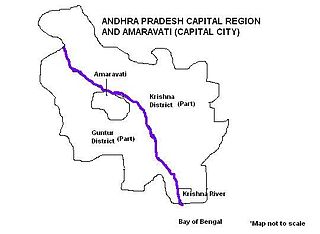
Andhra Pradesh Capital Region is the metropolitan region area surrounding Amaravati, the defacto capital city of Andhra Pradesh. It includes the major ancient cities of Vijayawada, Guntur, and Tenali. Andhra Pradesh Capital Region is one of the largest populated urban areas in the world, with its suburbs Vijayawada, Guntur, and Tenali being the 3rd, 24th, 41st most densely populated cities in the world. Vijayawada is the most densely populated city in India while Guntur is 11th and Tenali is the most populated city of 14th place in Andhra Pradesh. Andhra Pradesh Capital Region is the most populated metropolitan area in the state of Andhra Pradesh and 8th in India. Entire region is under the jurisdiction of Andhra Pradesh Capital Region Development Authority, and covers an area of 8,603 km2 (3,322 sq mi) under 58 mandals, of which 29 are in Krishna district and 29 in Guntur district. The capital region covers 18 mandals fully and 11 mandals partially in Guntur district. In Krishna district, it covers 15 mandals fully and 14 mandals partially under the jurisdiction of APCRDA. The capital city is an Urban Notified Area, and will cover 217.23 km2 (83.87 sq mi), within the Andhra Pradesh Capital Region. As of 1, August 2020, Andhra Pradesh proposed three capitals, which are Visakhapatnam as the executive capital, Amaravati as the legislative capital, and Kurnool as the judicial capital but the process is put on hold by High court and extended status quo till further orders.

Vemuru mandal is one of the 57 mandals in Guntur district of the state of Andhra Pradesh in India. It is under the administration of Tenali Revenue Division and the headquarters are located at Vemuru. The mandal is bounded by Tenali, Kollipara and Kollur, Amruthalur, Cherukupalle and Bhattiprolu mandals. The mandal is also a part of the Andhra Pradesh Capital Region under the jurisdiction of APCRDA.

Amaravati is the legislative capital and the de facto seat of government of the Indian state of Andhra Pradesh. The city is located on the banks of river Krishna in Guntur District and the primary city of the state's Capital Region. Built on allotted space on the southern banks of Krishna River in Guntur district selected close to the geographical center of the state.
Tondaimandalam, also known as Tondai Nadu or modern-day Pallava Nadu, is a historical region located in the northern part of Tamil Nadu and the southeastern part of Andhra Pradesh. The region comprises the districts that formed a part of the traditional Malayaman kingdom. The boundaries of Tondaimandalam are ambiguous – between the Rivers basins of Penna River and Ponnaiyar River. During the reign of Rajaraja I, this region was called as Jayankonda Cholamandalam.
References
- ↑ Talbot, Cynthia (20 September 2001). Precolonial India in Practice: Society, Region, and Identity in Medieval Andhra. Oxford University Press. p. 278. ISBN 978-0-19-803123-9.