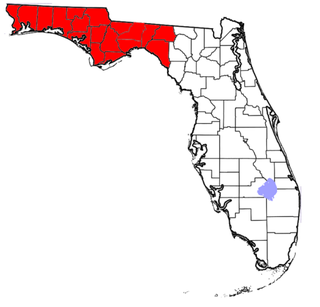
Escambia County is the westernmost and oldest county in the U.S. state of Florida. It is in the state's northwestern corner. At the 2020 census, the population was 321,905. Its county seat and largest city is Pensacola. Escambia County is included within the Pensacola-Ferry Pass-Brent, Florida, Metropolitan Statistical Area. The county population has continued to increase as the suburbs of Pensacola have developed.

Pensacola is the westernmost city in the Florida Panhandle. It is the county seat and only incorporated city of Escambia County, Florida, United States. At the 2020 census, the population was 54,312. It is the principal city of the Pensacola metropolitan area, which had 509,905 residents in 2020.

A tornado watch is a severe weather watch product of the National Weather Service that is issued by national weather forecasting agencies when meteorological conditions are favorable for the development of severe thunderstorms capable of producing tornadoes. In addition to the potential for tornado development, thunderstorms that develop within the watch area may contain large hail, straight-line winds, intense rainfall and/or flooding that pose a similar damage risk as the attendant tornado threat. A tornado watch does not mean a tornado is active or will appear, just that favorable conditions increases the likelihood of such happening. A watch must not be confused with a tornado warning.

A severe thunderstorm watch is a statement issued by weather forecasting agencies to advise the public that atmospheric conditions in a given region may lead to the development of severe thunderstorms within the region over several hours. The criteria for issuing a watch varies from country to country and may also include torrential rainfall and tornadoes. A watch may also be issued several hours ahead of the arrival of a mature and organized complex of storms, such as a mesoscale convective system.

A severe thunderstorm warning is a type of public warning for severe weather that is issued by weather forecasting agencies worldwide when one or more severe thunderstorms have been detected by Doppler weather radar, observed by weather spotters, or reported by an emergency management agency, law enforcement, or the general public. Unlike a watch, a warning is issued to areas in the direct path of active severe thunderstorms, that are expecting a direct impact typically within an hour. Severe thunderstorms can cause property damage and injury due to large hail, high winds, and flooding due to torrential rainfall. The exact criteria to issue a warning varies from country to country.

The National Weather Service (NWS) is an agency of the United States federal government that is tasked with providing weather forecasts, warnings of hazardous weather, and other weather-related products to organizations and the public for the purposes of protection, safety, and general information. It is a part of the National Oceanic and Atmospheric Administration (NOAA) branch of the Department of Commerce, and is headquartered in Silver Spring, Maryland, within the Washington metropolitan area. The agency was known as the United States Weather Bureau from 1890 until it adopted its current name in 1970.

The Florida panhandle is the northwestern part of the U.S. state of Florida. It is a salient roughly 200 miles (320 km) long, bordered by Alabama on the north and the west, Georgia on the north, and the Gulf of Mexico to the south. Its eastern boundary is arbitrarily defined. It is defined by its southern culture and rural geography relative to the rest of Florida, as well as closer cultural links to French-influenced Louisiana, Mississippi, and Alabama. Its major communities include Pensacola, Navarre, Destin, Panama City Beach, and Tallahassee.

Hurricane Erin was the first hurricane to strike the contiguous United States since Hurricane Andrew in 1992. The fifth tropical cyclone, fifth named storm, and second hurricane of the unusually active 1995 Atlantic hurricane season, Erin developed from a tropical wave near the southeastern Bahamas on July 31. Moving northwestward, the cyclone intensified into a Category 1 hurricane on the Saffir–Simpson scale near Rum Cay about 24 hours later. After a brief jog to the north-northwest on August 1, Erin began moving to the west-northwest. The cyclone then moved over the northwestern Bahamas, including the Abaco Islands and Grand Bahama. Early on August 2, Erin made landfall near Vero Beach, Florida, with winds of 85 mph (137 km/h). The hurricane weakened while crossing the Florida peninsula and fell to tropical storm intensity before emerging into the Gulf of Mexico later that day.

It is very rare for snow to fall in the U.S. state of Florida, especially in the central and southern portions of the state. With the exception of the far northern areas of the state, most of the major cities in Florida have never recorded measurable snowfall, though trace amounts have been recorded, or flurries in the air observed few times each century. According to the National Weather Service, in the Florida Keys and Key West there is no known occurrence of snow flurries since the European colonization of the region more than 300 years ago. In Miami, Fort Lauderdale, and Palm Beach there has been only one known report of snow flurries observed in the air in more than 200 years; this occurred in January 1977. In any event, Miami, Fort Lauderdale, and Palm Beach have not seen snow flurries before or since this 1977 event.
A tornado emergency is an enhanced version of a tornado warning, which is used by the National Weather Service (NWS) in the United States during imminent, significant tornado occurrences in highly populated areas. Although it is not a new warning type from the NWS, issued instead within a severe weather statement or in the initial tornado warning, a tornado emergency generally means that significant, widespread damage is expected to occur and a high likelihood of numerous fatalities is expected with a large, strong to violent tornado.

National Weather Service Lincoln, Illinois also known as National Weather Service Central Illinois is a weather forecast office responsible for monitoring weather conditions for 35 counties in Central and Southeastern Illinois. The Central Illinois office initially consisted of two forecast offices in Peoria and Springfield until the current location in Lincoln became the sole local forecast office in 1995. Federal meteorology offices and stations in the region date back to the 19th century when the Army Signal Service began taking weather observations using weather equipment at the Springer Building in Springfield. Since that time the presence of the National Weather Service greatly increased with the installation of new weather radars, stations and forecast offices. The current office in Lincoln maintains a WSR-88D (NEXRAD) radar system, and Advanced Weather Interactive Processing System (AWIPS) that greatly improve forecasting in the region. Lincoln is in charge of weather forecasts, warnings and local statements as well as aviation weather.

National Weather Service - Tulsa, Oklahoma (TSA) is a local weather forecast office responsible for monitoring weather conditions for 7 counties in Northwestern Arkansas, and 25 counties in Eastern Oklahoma. The current office in Tulsa maintains a WSR-88D (NEXRAD) radar system, and Advanced Weather Interactive Processing System (AWIPS) that greatly improve forecasting in the region. Tulsa is in charge of weather forecasts, warnings and local statements as well as aviation weather and NOAA Weather Radio broadcasts in its service area. The office operates two Doppler weather radars, one in Tulsa (INX), and the other in Fort Smith, Arkansas (SRX). Steve Piltz is the Meteorologist-In-Charge (MIC) of this office.

The 1932 Florida–Alabama hurricane was a tropical cyclone that made two separate landfalls on the United States, causing devastation in affected areas. The third named storm and hurricane of the 1932 Atlantic hurricane season, it developed from a tropical disturbance north of Hispaniola on August 26. Slowly moving towards the west-northwest, the system intensified to tropical storm strength before making landfall on South Florida early on August 30. After crossing the Florida peninsula and entering the Gulf of Mexico, the system reached peak intensity as a Category 1 hurricane, before subsequently making its final landfall near the Mississippi–Alabama border on September 1. Over land, the hurricane weakened, and after becoming an extratropical cyclone on September 2, merged with another extratropical system over Quebec on September 4.

National Weather Service - Norman, Oklahoma is a Weather Forecast Office (WFO) of the National Weather Service based in Norman, Oklahoma, which is responsible for forecasts and the dissemination of weather warnings and advisories for central and most of western Oklahoma, and western portions of north Texas. It is located in the National Weather Center on the University of Oklahoma campus, where it acts as one of the NOAA Weather Partners, a group of close-together weather-related agencies of the National Oceanic and Atmospheric Administration. NWS Norman is currently overseen by Mark Fox, who serves as the Meteorologist In Charge of the office.
The National Weather Service Boston/Norton, Massachusetts, is a local office of the National Weather Service (NWS), run under the auspices of the NWS's Eastern Region. This weather forecast office (WFO) is responsible for monitoring weather conditions throughout most of southern New England. The southern New England weather forecast office provides warning and forecast services for most of Massachusetts, Northern Connecticut, and all of Rhode Island. Besides public weather services, WFO Norton (BOX) provides marine, aviation, fire weather, and hydrological forecast services. Additional hydrologic information is provided by the co-located Northeast River Forecast Center (NERFC).

A relatively widespread, damaging, and deadly tornado outbreak struck the central and southern United States in late April 2014. The storm complex responsible for the outbreak produced multiple long-track tornadoes – seven of which were deadly, causing 35 fatalities. One additional death occurred in Florida, due to severe flooding associated with this system.

National Weather Service - Pleasant Hill/Kansas City, Missouri is a Weather Forecast Office (WFO) of the National Weather Service, which is responsible for forecasts and the dissemination of weather warnings and advisories for 37 counties in northern and western Missouri and seven counties in extreme eastern Kansas, including the Kansas City and St. Joseph metropolitan areas. Though, as the Storm Prediction Center (SPC) in Norman, Oklahoma is responsible for issuing severe thunderstorm and tornado watches, the Pleasant Hill/Kansas City WFO only composes outline and status updates for SPC-issued watches affecting any portion of its designated County Warning Area.

An unusually prolific and very destructive late-winter tornado outbreak resulted in significant damage and numerous casualties across the southern and eastern half of the United States between February 23–24, 2016. Lasting over a day and a half, the outbreak produced a total of 61 tornadoes across eleven states, which ranked it as one of the largest February tornado outbreaks in the United States on record, with only the 2008 Super Tuesday tornado outbreak having recorded more. In addition, it was also one of the largest winter tornado outbreaks overall as well. The most significant and intense tornadoes of the event were four EF3 tornadoes that struck southeastern Louisiana, Pensacola, Florida, Evergreen, Virginia, and Tappahannock, Virginia. Tornadoes were also reported in other places like Texas, Florida, and Pennsylvania. Severe thunderstorms, hail and gusty winds were also felt in the Northeastern United States and Mid-Atlantic states on February 24 as well.
A small but damaging outbreak of 11 tornadoes impacted the Southeastern United States on the last two days of March 1962. The outbreak was highlighted by a catastrophic, mid-morning F3 tornado that destroyed multiple neighborhoods in Milton, Florida, killing 17 people and injuring 100 others. It was the deadliest tornado ever recorded in Florida until 1998. Overall, the outbreak killed 17 people, injured 105 others, and caused $3.38 million in damage. Lightning caused another two deaths and three injuries.

Hurricane Sally was a destructive and slow-moving Atlantic hurricane that was the first hurricane to make landfall in the U.S. state of Alabama since Ivan in 2004, coincidentally on the same date in the same place. The eighteenth named storm and seventh hurricane of the extremely active 2020 Atlantic hurricane season, Sally developed from an area of disturbed weather which was first monitored over the Bahamas on September 10. The system grew a broad area of low-pressure on September 11, and was designated as a tropical depression late that day. Early the next day, the depression made landfall at Key Biscayne and subsequently strengthened into Tropical Storm Sally that afternoon. Moderate northwesterly shear prevented significant intensification for the first two days, but convection continued to grow towards the center and Sally slowly intensified. On September 14, a center reformation into the center of the convection occurred, and data from a hurricane hunter reconnaissance aircraft showed that Sally had rapidly intensified into a strong Category 1 hurricane. However, an increase in wind shear and upwelling of colder waters halted the intensification and Sally weakened slightly on September 15 before turning slowly northeastward. Despite this increase in wind shear, it unexpectedly re-intensified, reaching Category 2 status early on September 16 before making landfall at peak intensity at 09:45 UTC on September 16, near Gulf Shores, Alabama, with maximum sustained winds of 110 mph (180 km/h) and a minimum central pressure of 965 millibars (28.5 inHg). The storm rapidly weakened after landfall before transitioning into an extratropical low at 12:00 UTC the next day. Sally's remnants lasted for another day as they moved off the coast of the Southeastern United States before being absorbed into another extratropical storm on September 18.


