
A tornado warning is a public warning that is issued by weather forecasting agencies to an area in the direct path of a tornado or a thunderstorm that is capable of producing a tornado. Modern weather surveillance technology such as Doppler weather radar allow for early detection of rotation in a thunderstorm, and for subsequent warnings to be issued before a tornado actually develops. It is nevertheless still not uncommon that warnings are issued based on reported visual sighting of a tornado, funnel cloud, or wall cloud, typically from weather spotters or the public, but also law enforcement or local emergency management. In particular, a tornado can develop in a gap of radar coverage, of which there are several known in the United States.

The Tornado outbreak sequence of March 9–13, 2006 was an early season and long lasting tornado outbreak sequence in the central United States that started on the morning of March 9 and continued for over four days until the evening of March 13. The outbreak produced 99 confirmed tornadoes, which killed a total of 10 people. The Storm Prediction Center (SPC) issued multiple elavated outlook throughout the sequence, including a rare high risk for March 12, which would end up being the most intense day of the outbreak, producing 62 in total. 11 F3 tornadoes were tallied, and a violent F4 tornado touched down in Monroe County, Missouri, becoming the strongest of the outbreak. Multiple tornado emergencies were issued for tornadoes throughout the outbreak as well. An intense F3 tornado that affected the towns of Renick and Maddison in Missouri killed 4 people and injured dozens others, becoming the deadliest of the sequence. Multiple of the tornadoes were long-tracked in nature, with 6 of them having paths exceeding 30 miles (48 km). One particular supercell thunderstorm during the outbreak persisted for many hours and progressed in excess of 800 miles (1,300 km) through Oklahoma, Kansas, Missouri, Illinois, Indiana, and extreme southern Michigan.
A tornado emergency is an enhanced version of a tornado warning, which is used by the National Weather Service (NWS) in the United States during imminent, significant tornado occurrences in highly populated areas. Although it is not a new warning type from the NWS, issued instead within a severe weather statement or in the initial tornado warning, a tornado emergency generally means that significant, widespread damage is expected to occur and a high likelihood of numerous fatalities is expected with a large, strong to violent tornado.
An unseasonably strong tornado outbreak began on January 7, 2008, and continued for nearly four days across the Central and Southern United States, with the hardest hit area being southwestern Missouri, northwestern Arkansas, and the surrounding area. In addition, a strong supercell in northern Illinois and southeastern Wisconsin produced that region's first January tornadoes since 1967.

A destructive and deadly tornado outbreak that took place across the Southern and Central United States from May 1 to May 3, 2008. The outbreak was responsible for at least seven fatalities and 23 injuries in Arkansas. There were at least 29 tornado reports from Iowa to Oklahoma on May 1 and 67 more in Arkansas, Missouri, Mississippi, Tennessee, Louisiana and Texas on May 2. A total of 60 tornadoes were confirmed by weather authorities.

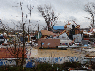
The 2010 New Year's Eve tornado outbreak was a three-day-long tornado outbreak that impacted the central and lower Mississippi Valley from December 30, 2010 to January 1, 2011. Associated with a low pressure system and a strong cold front, 37 tornadoes tracked across five states over the length of the severe event, killing nine and injuring several others. Activity was centered in the states of Missouri and later Mississippi on December 31. Seven tornadoes were rated EF3 on the Enhanced Fujita Scale; these were the strongest during the outbreak. Non-tornadic winds were recorded to have reached as high as 80 mph (130 km/h) at eight locations on December 31, while hail as large as 2.75 in (7.0 cm) was documented north-northeast of Mansfield, Missouri. Overall, damage from the outbreak totaled US$123.3 million, most of which was related to tornadoes. This is the most prolific tornado outbreak in Missouri in the month of December.
The Sperry–Piltz Ice Accumulation Index, or SPIA Index, is a scale for rating ice storm intensity, based on the expected footprint of an ice storm, the expected ice accumulation as a result of a storm, and the expected damage a storm inflicts on human-built structures, especially exposed overhead utility systems such as power lines.

National Weather Service - North Little Rock, AR, also known as National Weather Service - Little Rock, AR, is a local weather forecast office responsible for monitoring weather conditions for 47 of Arkansas's 75 counties, excluding 7 counties in Northwestern Arkansas, 9 counties in Southwestern and South Central Arkansas, Ashley and Chicot counties in Extreme Southeastern Arkansas, and 14 counties in Eastern Arkansas. Those counties are monitored by the Weather Service offices in Tulsa, Shreveport, Jackson (MS), and Memphis respectively. The current office in North Little Rock maintains a WSR-88D (NEXRAD) radar system and Advanced Weather Interactive Processing System (AWIPS) that greatly improve forecasting in the region. North Little Rock is in charge of weather forecasts, warnings and local statements as well as aviation weather. The name of the Doppler weather radar (WSR-88D) code used by this office is LZK. The National Weather Service at North Little Rock, Arkansas programs 12 NOAA Weather Radio transmitters across Arkansas, with 25 transmitters statewide.

National Weather Service - Memphis, TN is a local weather forecast office responsible for monitoring weather conditions in the U.S. Mid-South region for counties in Eastern Arkansas, the Missouri Bootheel, Northern Mississippi, and Western Tennessee. The current office in Memphis maintains a WSR-88D (NEXRAD) radar system, and Advanced Weather Interactive Processing System (AWIPS) that greatly improve forecasting in the region. Memphis is in charge of weather forecasts, warnings and local statements as well as aviation weather. The name of the Doppler weather radar (WSR-88D) used by this office is MEG. Darone Jones is the Meteorologist-In-Charge (MIC) of this office.
National Weather Service - Shreveport, LA (SHV) is one of 122 weather forecast offices around the United States. It is responsible for issuing public and aviation forecasts and warning for South Central and Southwestern Arkansas, Southeastern Oklahoma, and Eastern and Northeastern Texas Counties, as well as for North Central and Northwestern Louisiana Parishes. It is co-located with a weather radar (KSHV) of the NEXRAD network and an upper air sounding facility. It controls the issuance of weather information and bulletins on a certain number of NOAA Weather Radio.

The December 17–22, 2012 North American blizzard was a winter storm that affected the Midwestern and Eastern United States. Forming on December 17, the winter storm moved across the midwest, forcing schools to close throughout the region. Numerous warnings and advisories had been posted by the National Weather Service for many states, including Iowa, Nebraska, Illinois, and Wisconsin. Both O'Hare International Airport and Midway International Airport in Chicago, Illinois canceled most departures and arrivals. According to flight tracking website FlightStats.com, more than 1,000 flights were canceled across the region. More than 130,000 customers were without power across the west and midwest.

The National Weather Service Amarillo, Texas, is a weather forecast office that serves 23 counties in the Texas and Oklahoma Panhandles by providing weather forecasts for the many communities it serves as well as airports in Guymon, Dalhart, and Amarillo. The office was established on January 1, 1892, only 5 years after the city of Amarillo was founded. The office operates a WSR-88D (NEXRAD) radar and a number of ASOS sensor suites in order to monitor the latest weather conditions. An AWIPS system is used by the office to produce forecasts, warnings, and advisories.
National Weather Service - Norman, Oklahoma is a Weather Forecast Office (WFO) of the National Weather Service based in Norman, Oklahoma, which is responsible for forecasts and the dissemination of weather warnings and advisories for central and most of western Oklahoma, and western portions of north Texas. It is located in the National Weather Center on the University of Oklahoma campus, where it acts as one of the NOAA Weather Partners, a group of close-together weather-related agencies of the National Oceanic and Atmospheric Administration. NWS Norman is currently overseen by Mark Fox, who serves as the Meteorologist In Charge of the office.

Preceded by more than a week of heavy rain, a slow-moving storm system dropped tremendous precipitation across much of Texas and Oklahoma during the nights of May 24–26, 2015, triggering record-breaking floods. Additionally, many areas reported tornado activity and lightning. Particularly hard hit were areas along the Blanco River in Hays County, Texas, where entire blocks of homes were leveled. On the morning of May 26, the National Weather Service issued a flash flood emergency for southwest Harris County and northeast Fort Bend County. The system also produced deadly tornadoes in parts of Mexico, Texas, and Oklahoma. This flood significantly contributed to the wettest month ever for Texas and Oklahoma.
National Weather Service - Pleasant Hill/Kansas City, Missouri is a Weather Forecast Office (WFO) of the National Weather Service, which is responsible for forecasts and the dissemination of weather warnings and advisories for 37 counties in northern and western Missouri and seven counties in extreme eastern Kansas, including the Kansas City and St. Joseph metropolitan areas. Though, as the Storm Prediction Center (SPC) in Norman, Oklahoma is responsible for issuing severe thunderstorm and tornado watches, the Pleasant Hill/Kansas City WFO only composes outline and status updates for SPC-issued watches affecting any portion of its designated County Warning Area.

The 2017 Tulsa tornado took place on August 6, 2017, near Tulsa, Oklahoma. Major damage was inflicted on a shopping and office area in midtown Tulsa. There were no fatalities, although 30 people were injured. It was part of a small outbreak of four tornadoes that formed along a bow echo.

The April 2018 North American storm complex brought a wide swath of severe and winter weather that affected much of Midwest across to the East Coast of the United States. This particular outbreak led to at least 73 confirmed tornadoes over a three-day period, most of which occurred across Arkansas and Louisiana during the evening hours of April 13. The most significant tornadoes were an EF1 that caused a fatality in Red Chute, Louisiana, early on April 14, an upper-end EF2 tornado that impacted eastern sections of Greensboro, North Carolina on April 15, causing 17 injuries, and a significant EF3 tornado that impacted areas from Lynchburg to Elon, Virginia, causing severe damage and at least 10 injuries.

The tornado outbreak of November 30 – December 2, 2018 was a late-season tornado outbreak that occurred across portions of the West South Central states and Midwestern United States. As a potent shortwave trough moved across the southern portions of the country, it was met with ample moisture return and destabilization, resulting in widespread severe thunderstorms that produced damaging winds, hail, and tornadoes. The event began late on November 30 in Oklahoma, spreading east and resulting in one fatality in Aurora, Missouri. Several tornadic supercells moved across portions of Illinois on December 1, and resulted in 29 confirmed tornadoes. This outbreak was the largest December tornado event on record in Illinois history, surpassing the December 1957 tornado outbreak sequence. The most significant tornado of the event was an EF3 that impacted Taylorville, Illinois, damaging or destroying hundreds of structures and injuring 22 people.

A significant severe weather event impacted the South Central United States between October 20–22, 2019. Forecasters first identified the threat on October 16 as a large upper-level trough was expected to combine with an unstable atmosphere across Texas, Oklahoma, and Arkansas particularly. On the evening of October 20, discrete supercell thunderstorms developed across the Dallas–Fort Worth metroplex, contributing to several tornadoes. One of those tornadoes caused EF3 damage in the Dallas suburbs, becoming the costliest tornado event in Texas history, at $1.55 billion. A later squall line contributed to additional tornadoes and a widespread swath of damaging winds as the system tracked eastward.