The National Weather Service Amarillo, Texas, is a weather forecast office that serves 23 counties in the Texas and Oklahoma Panhandles by providing weather forecasts for the many communities it serves as well as airports in Guymon, Dalhart, and Amarillo. The office was established on January 1, 1892, only 5 years after the city of Amarillo was founded. The office operates a WSR-88D (NEXRAD) radar and a number of ASOS sensor suites in order to monitor the latest weather conditions. An AWIPS system is used by the office to produce forecasts, warnings, and advisories.
The first Amarillo weather office was established by moving the Army Signal office from Fort Sill, Indian Territory (now Oklahoma). Mr. Wayland Bailey, Observer in Charge, relocated the office furnishings and instrumentation into the Amarillo Opera House which was located at the northwest corner of Polk and 5th streets. The instrumentation was located on the roof of this building.[1]
In this age of rapid weather dissemination of severe weather watches and warnings, Mr. Bailey did not have much foresight. In 1894, Mr. Bailey wrote in the local station log: "I respectfully recommend that cold wave signals and rain warnings be discontinued, as they are of little benefit to this community." At that time, cold wave signals were generally issued after cold air had already arrived. The signals were disseminated in the form of a six by eight foot flag, which was raised at the weather office. Also, as is today, the Weather Bureau depended on local media such as the "Amarillo Champion" and the "Northwesterner" to relay this information to the public.[1]
By 1895, Mr. Bailey began to appreciate just how important forecasts and warnings were to the people of this region. Again he wrote in the station log: "The citizens of the town take considerable interest in the forecasts, but are more interested in the probable force and direction of the wind, which is the most important feature of the weather here." More than one hundred years later, the same can be said today.[1]
Three more men held the title of Observer in Charge, until April 1902 when Mr. Peter Wood became the first Official in Charge. Mr. Wood opened Amarillo's first Weather Bureau building in June 1903 on the southeast corner of Taylor and Seventh Streets. This two-story building housed the weather office on its first floor, with quarters for the Official in Charge on the second floor.[1]
In November 1906, Mr. T.J. Considine took the reins of the Amarillo Weather Bureau and held them until he died in January 1925. Mr. Considine may have been Amarillo's first true weatherman because during his tenure, he recorded a wide variety of weather conditions. Mr. Considine wrote of winters that created snow drifts of four to five feet that suspended local street car service. He endured record breaking snowfalls that still stand in current record books. In 1908, perhaps the first Weather Bureau account of an Amarillo tornado was recorded on June 6. Mr. Considine wrote: "several funnel shaped clouds were quite noticeable, their distance from the station being between 2 to 3 miles. One of these tornadic conditions descended about two miles outside of town, damaging a dwelling house and a wind mill."[1]
Through the early part of this century, the Weather Bureau in Amarillo continued to grow from a one-man station to one that employed several employees. By the early 1930s, the Bureau's focus began to shift to a rapidly growing aviation industry. A separate Weather Bureau Airport Station was established at English Field in 1932. The Weather Bureau later closed the station in 1935 and transferred airport observing responsibilities to the Civil Aeronautics Administration.[1]
The focus on aviation prompted the move of the Weather Bureau into the Department of Commerce in June 1940. In April 1941, the Weather Bureau closed its downtown office and consolidated all weather observing activities at the Amarillo Air Terminal. Mr. Henry Winburn became Amarillo's first Meteorologist in Charge and continued in that position until his death in 1962. Like Mr. Considine, Winburn dealt with a great many changes and problems.[1]
Amarillo Weather Bureau, June 1, 1903
With the outbreak of World War II, Mr. Winburn had to manage with a rapid change in personnel. The war created a shortage of personnel in an organization that was predominately staffed with male employees. A manpower shortage resulted in a large influx of women employees into the Bureau. The Amarillo office employed eleven female observers from the period of 1943 through 1946. However, the first female employee was Miss Angela Considine who was employed by her father as an assistant observer in 1920.[1]
Throughout the early history of the Weather Bureau, severe weather or tornado warnings were not issued. The Bureau felt that these warnings would do nothing more than panic the local populations. In fact, the word "tornado" was considered taboo until warnings were first issued in 1950. This policy did not deter Winburn who, in May 1949, pioneered broadcast warnings. Winburn went on the radio airwaves to warn Amarilloans of an impending tornado. Six persons died in the tornado, and a local newspaper was highly critical of Weather Bureau actions. An investigation revealed that the local office responded quite appropriately, especially considering the Weather Bureau policy on warnings. In fact, the local office received letters of commendation from the Chief of the Bureau and the Secretary of Commerce.[1]
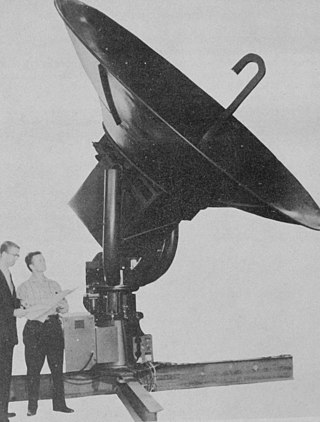
Winburn was also involved in the implementation of the first operational weather radars. In 1952, a Radar Storm Detection Unit, which was a modified World War II Navy radar, was installed in Amarillo. Then, in 1961, one of the Weather Bureau's first network weather radars (WSR-57) was commissioned in Amarillo. Other rapid changes in technology were ushered in by Winburn, such as the installation of warning teletype communications in 1955, and the transfer of Upper Atmospheric (Radiosonde) observations to the local office in 1956.[1]
The office was moved to its present location of 1900 English Road in 1989. The new office was constructed to accommodate not only the latest advances in technology, but also a larger staff. Meteorologists were added to the staff, which resulted in forecasting responsibilities for the Texas and Oklahoma Panhandles. In 1992, an Automated Surface Observing System was commissioned, one of the first of its kind in the nation. A WSR-88D Doppler Weather Radar was commissioned in March 1994. This radar was the second commissioned in the country and the first in the state of Texas.[1]
NOAA Weather Radio
The National Weather Service office in Amarillo broadcasts several NOAA Weather Radio stations across its county warning area.
Counties served
The Counties listed below are monitored 24/7 by the National Weather Service Office in Amarillo, Texas
The National Weather Service (NWS) is an agency of the United States federal government that is tasked with providing weather forecasts, warnings of hazardous weather, and other weather-related products to organizations and the public for the purposes of protection, safety, and general information. It is a part of the National Oceanic and Atmospheric Administration (NOAA) branch of the Department of Commerce, and is headquartered in Silver Spring, Maryland, within the Washington metropolitan area. The agency was known as the United States Weather Bureau from 1891 until it adopted its current name in 1970.
NEXRAD or Nexrad is a network of 159 high-resolution S-band Doppler weather radars operated by the National Weather Service (NWS), an agency of the National Oceanic and Atmospheric Administration (NOAA) within the United States Department of Commerce, the Federal Aviation Administration (FAA) within the Department of Transportation, and the U.S. Air Force within the Department of Defense. Its technical name is WSR-88D.
WSR-74 radars were Weather Surveillance Radars designed in 1974 for the National Weather Service. They were added to the existing network of the WSR-57 model to improve forecasts and severe weather warnings. Some have been sold to other countries like Australia, Greece, and Pakistan.
WSR-57 radars were the primary weather surveillance radar used by the United States for over 35 years. The National Weather Service operated a network of this model radar across the country, watching for severe weather.
The National Severe Storms Laboratory (NSSL) is a National Oceanic and Atmospheric Administration (NOAA) weather research laboratory under the Office of Oceanic and Atmospheric Research. It is one of seven NOAA Research Laboratories (RLs).
The WSR-1 or Weather Surveillance Radar-1 was one of the first weather radars and the first used by a civilian organization in the US. The WSR-1 series was a modified version of the AN/APS-2F radar, which the Weather Bureau acquired from the Navy. The WSR-1A, WSR-3, and WSR-4 were also variants of this radar. The first WSR-1 in the USA was at Washington National Airport in Washington, D.C., in 1947, and the last WSR-3 was retired by 1978.
A tornadic vortex signature, abbreviated TVS, is a Pulse-Doppler radar weather radar detected rotation algorithm that indicates the likely presence of a strong mesocyclone that is in some stage of tornadogenesis. It may give meteorologists the ability to pinpoint and track the location of tornadic rotation within a larger storm, and is one component of the National Weather Service's warning operations.
Storm spotting is a form of weather spotting in which observers watch for the approach of severe weather, monitor its development and progression, and actively relay their findings to local authorities.
The Warning Decision Training Division (WDTD), known as the Warning Decision Training Branch until April 1, 2015, is one of three training organizations in the NWS Training Division which also includes the Forecast Decision Training Branch and the NWS Training Center. WDTD develops and delivers training on the integrated elements of the warning process within a National Oceanic and Atmospheric Administration (NOAA)/National Weather Service (NWS) forecast office. WDTD instructors develop and deliver a variety of in-residence, teletraining, and on-line asynchronous training content.
National Weather Service Lincoln, Illinois also known as National Weather Service Central Illinois is a weather forecast office responsible for monitoring weather conditions for 35 counties in Central and Southeastern Illinois. The Central Illinois office initially consisted of two forecast offices in Peoria and Springfield until the current location in Lincoln became the sole local forecast office in 1995. Federal meteorology offices and stations in the region date back to the 19th century when the Army Signal Service began taking weather observations using weather equipment at the Springer Building in Springfield. Since that time the presence of the National Weather Service greatly increased with the installation of new weather radars, stations and forecast offices. The current office in Lincoln maintains a WSR-88D (NEXRAD) radar system, and Advanced Weather Interactive Processing System (AWIPS) that greatly improve forecasting in the region. Lincoln is in charge of weather forecasts, warnings and local statements as well as aviation weather.
National Weather Service Little Rock, Arkansas is a local weather forecast office responsible for monitoring weather conditions for 47 of Arkansas's 75 counties, excluding 7 counties in Northwestern Arkansas, 9 counties in Southwestern and South Central Arkansas, Ashley and Chicot counties in Extreme Southeastern Arkansas, and 14 counties in Eastern Arkansas. Those counties are monitored by the Weather Service offices in Tulsa, Shreveport, Jackson (MS), and Memphis respectively. The current office in North Little Rock maintains a WSR-88D (NEXRAD) radar system and Advanced Weather Interactive Processing System (AWIPS) that greatly improve forecasting in the region. North Little Rock is in charge of weather forecasts, warnings and local statements as well as aviation weather. The name of the Doppler weather radar (WSR-88D) code used by this office is LZK. The National Weather Service at North Little Rock, Arkansas programs 12 NOAA Weather Radio transmitters across Arkansas, with 25 transmitters statewide.
National Weather Service - Memphis, TN is a local weather forecast office responsible for monitoring weather conditions in the U.S. Mid-South region for counties in Eastern Arkansas, the Missouri Bootheel, Northern Mississippi, and Western Tennessee. The current office in Memphis maintains a WSR-88D (NEXRAD) radar system, and Advanced Weather Interactive Processing System (AWIPS) that greatly improve forecasting in the region. Memphis is in charge of weather forecasts, warnings and local statements as well as aviation weather. The name of the Doppler weather radar (WSR-88D) used by this office is MEG. Darone Jones is the Meteorologist-In-Charge (MIC) of this office.
National Weather Service - Tulsa, Oklahoma (TSA) is a local weather forecast office responsible for monitoring weather conditions for 7 counties in Northwestern Arkansas, and 25 counties in Eastern Oklahoma. The current office in Tulsa maintains a WSR-88D (NEXRAD) radar system, and Advanced Weather Interactive Processing System (AWIPS) that greatly improve forecasting in the region. Tulsa is in charge of weather forecasts, warnings and local statements as well as aviation weather and NOAA Weather Radio broadcasts in its service area. The office operates two Doppler weather radars, one in Tulsa (INX), and the other in Fort Smith, Arkansas (SRX). Steve Piltz is the Meteorologist-In-Charge (MIC) of this office.
National Weather Service - Norman, Oklahoma is a Weather Forecast Office (WFO) of the National Weather Service based in Norman, Oklahoma, which is responsible for forecasts and the dissemination of weather warnings and advisories for central and most of western Oklahoma, and western portions of north Texas. It is located in the National Weather Center on the University of Oklahoma campus, where it acts as one of the NOAA Weather Partners, a group of close-together weather-related agencies of the National Oceanic and Atmospheric Administration. NWS Norman is currently overseen by Mark Fox, who serves as the Meteorologist In Charge of the office.
The National Weather Service Boise, Idaho is a weather forecast office responsible for weather forecasts, warnings and local statements as well as aviation weather forecasts and fire weather forecasts for 3 counties in Southeast Oregon and 14 counties in Southwest and South central Idaho. The U.S. Weather Bureau established an office in the Sonna Building on December 1, 1898. Since then, the U.S Weather Bureau office, now known as the National Weather Service forecast office gained forecast responsibility of Southern Idaho on June 22, 1970 which was expanded to the entire state of Idaho in 1973. After modernization in 1993, the forecast responsibility was changed to Southeast Oregon and Southwest Idaho. The current office in Boise maintains a WSR-88D (NEXRAD) radar system, 8 Automated airport weather station (ASOS) systems and Advanced Weather Interactive Processing System (AWIPS) that greatly improve forecasting in the region. Continuous weather observations have been maintained for the city of Boise since February 1, 1864 about 5 months after the U.S. Army established Fort Boise. The post surgeon for the U.S. Army took observations until July 1, 1877 when the U.S. Signal Service, established an office downtown. The Signal Office was discontinued on July 1, 1890.
National Weather Service Jackson, based in Jackson, Kentucky, is a weather forecast office responsible for monitoring weather conditions for 33 counties in Eastern Kentucky. The National Weather Service chose to put a weather forecast office (WFO) in eastern Kentucky due to the flooding of April 2-5, 1977. The National Weather Service Jackson, Kentucky has been forecasting for portions of Eastern Kentucky since 1981.
National Weather Service - Pleasant Hill/Kansas City, Missouri is a Weather Forecast Office (WFO) of the National Weather Service, which is responsible for forecasts and the dissemination of weather warnings and advisories for 37 counties in northern and western Missouri and seven counties in extreme eastern Kansas, including the Kansas City and St. Joseph metropolitan areas. Though, as the Storm Prediction Center (SPC) in Norman, Oklahoma is responsible for issuing severe thunderstorm and tornado watches, the Pleasant Hill/Kansas City WFO only composes outline and status updates for SPC-issued watches affecting any portion of its designated County Warning Area.
National Weather Service Nashville is a weather forecast office responsible for monitoring weather conditions for 38 counties in Middle Tennessee. The office is in charge of weather forecasts, warnings, and local statements as well as aviation weather. It is equipped with a WSR-88D (NEXRAD) radar and an Automated Surface Observing System (ASOS) that greatly increases the ability to forecast. While it is officially the Nashville forecast office, the WFO is technically located in Wilson County near Old Hickory, Tennessee, along the shoreline of Old Hickory Lake near the Davidson/Wilson County line.
National Weather Service Louisville is a weather forecast office responsible for monitoring weather conditions for 49 counties in north-central, south-central, and east-central Kentucky and 10 counties in southern Indiana. The office is in charge of weather forecasts, warnings and local statements as well as aviation weather. It is also equipped with a WSR-88D (NEXRAD) radar, and an Automated Surface Observing System (ASOS) that greatly increase the ability to forecast. The NEXRAD radar site utilized by the forecast office is located near West Point, Kentucky on the north side of the Fort Knox Military Reservation.
The National Weather Service Gray/Portland, Maine (GYX) is a local office of the National Weather Service responsible for monitoring weather conditions over western Maine and all of New Hampshire. It is situated in Gray, Maine, in the metropolitan area of Portland, in a rural setting.
This page is based on this Wikipedia article Text is available under the CC BY-SA 4.0 license; additional terms may apply. Images, videos and audio are available under their respective licenses.