The National Oceanic and Atmospheric Administration is an American scientific and regulatory agency charged with forecasting weather, monitoring oceanic and atmospheric conditions, charting the seas, conducting deep-sea exploration, and managing fishing and protection of marine mammals and endangered species in the US exclusive economic zone. The agency is part of the United States Department of Commerce and is headquartered in Silver Spring, Maryland.

The National Weather Service (NWS) is an agency of the United States federal government that is tasked with providing weather forecasts, warnings of hazardous weather, and other weather-related products to organizations and the public for the purposes of protection, safety, and general information. It is a part of the National Oceanic and Atmospheric Administration (NOAA) branch of the Department of Commerce, and is headquartered in Silver Spring, Maryland, within the Washington metropolitan area. The agency was known as the United States Weather Bureau from 1891 until it adopted its current name in 1970.

NOAA Weather Radio (NWR), also known as NOAA Weather Radio All Hazards, is an automated 24-hour network of VHF FM weather radio stations in the United States which broadcast weather information directly from a nearby National Weather Service office. Its routine programming cycle includes local or regional weather forecasts, synopsis, climate summaries or zone/lake/coastal waters forecasts, and can be shortened to specifically include hazardous weather outlooks, short-term forecasts, special weather statements or tropical weather summaries during hazardous weather events. It occasionally broadcasts other non-weather related events such as national security statements, natural disaster information, environmental and public safety statements such as AMBER Alerts, civil emergencies, fires, evacuation orders, and other hazards sourced from the Federal Communications Commission's (FCC) Emergency Alert System. NOAA Weather Radio uses automated broadcast technology that allows for the recycling of segments featured in one broadcast cycle into another and for consistent regular updating of segments to each of the transmitters.

NEXRAD or Nexrad is a network of 159 high-resolution S-band Doppler weather radars operated by the National Weather Service (NWS), an agency of the National Oceanic and Atmospheric Administration (NOAA) within the United States Department of Commerce, the Federal Aviation Administration (FAA) within the Department of Transportation, and the U.S. Air Force within the Department of Defense. Its technical name is WSR-88D.
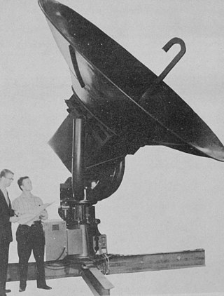
WSR-57 radars were the primary weather surveillance radar used by the United States for over 35 years. The National Weather Service operated a network of this model radar across the country, watching for severe weather.
Oceanic and Atmospheric Research (OAR) is a division of the National Oceanic and Atmospheric Administration (NOAA). OAR is also referred to as NOAA Research.
The National Severe Storms Laboratory (NSSL) is a National Oceanic and Atmospheric Administration (NOAA) weather research laboratory under the Office of Oceanic and Atmospheric Research. It is one of seven NOAA Research Laboratories (RLs).
The Cooperative Institute for Severe and High-Impact Weather Research and Operations (CIWRO) is one of 16 NOAA Cooperative Institutes (CIs), hosted at the University of Oklahoma. Before Oct. 1, 2021, it was known as the Cooperative Institute for Mesoscale Meteorological Studies (CIMMS). The CIMMS/CIWRO, a research organization created in 1978 by a cooperative agreement between the University of Oklahoma (OU) and the National Oceanic and Atmospheric Administration (NOAA), promotes collaborative research between NOAA and OU scientists on problems of mutual interest to improve basic understanding of mesoscale meteorological phenomena, weather radar, and regional climate to help produce better forecasts and warnings that save lives and property. CIMMS/CIWRO research contributes to the NOAA mission through improvement of the observation, analysis, understanding, and prediction of weather elements and systems and climate anomalies ranging in size from cloud nuclei to multi-state areas.

National Weather Service Lincoln, Illinois also known as National Weather Service Central Illinois is a weather forecast office responsible for monitoring weather conditions for 35 counties in Central and Southeastern Illinois. The Central Illinois office initially consisted of two forecast offices in Peoria and Springfield until the current location in Lincoln became the sole local forecast office in 1995. Federal meteorology offices and stations in the region date back to the 19th century when the Army Signal Service began taking weather observations using weather equipment at the Springer Building in Springfield. Since that time the presence of the National Weather Service greatly increased with the installation of new weather radars, stations and forecast offices. The current office in Lincoln maintains a WSR-88D (NEXRAD) radar system, and Advanced Weather Interactive Processing System (AWIPS) that greatly improve forecasting in the region. Lincoln is in charge of weather forecasts, warnings and local statements as well as aviation weather.
National Weather Service Paducah is a weather forecast office responsible for monitoring weather conditions for 58 counties in the states of Kentucky, Illinois, Indiana and Missouri. The Paducah office is relatively new compared to others, having been built in 1984. The office is in charge of weather forecasts, warnings and local statements as well as aviation weather. It is also equipped with a WSR-88D (NEXRAD) radar, and an Automated Surface Observing System (ASOS) that greatly increase the ability to forecast.
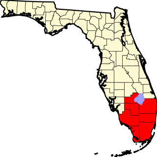
The National Weather Service Miami, Florida is a local weather forecast office of the National Weather Service (NWS) that serves six counties in South Florida – Broward, Collier, Glades, Hendry, Miami-Dade, and Palm Beach – as well as the mainland portion of Monroe County. This office was originally established in 1879 as a Signal Corps station near the Jupiter Inlet Light, before becoming a Weather Bureau Office (WBO) in 1891. The WBO at Jupiter was moved southward to Miami in 1911, due to the city's rapidly growing population. In 1930, a separate Weather Bureau Airport Station (WBAS) was established at the Miami Municipal Airport. The WBAS was later moved to the Miami International Airport in 1942 and remained there until ceasing operations in 1975.
National Weather Service - Tulsa, Oklahoma (TSA) is a local weather forecast office responsible for monitoring weather conditions for 7 counties in Northwestern Arkansas, and 25 counties in Eastern Oklahoma. The current office in Tulsa maintains a WSR-88D (NEXRAD) radar system, and Advanced Weather Interactive Processing System (AWIPS) that greatly improve forecasting in the region. Tulsa is in charge of weather forecasts, warnings and local statements as well as aviation weather and NOAA Weather Radio broadcasts in its service area. The office operates two Doppler weather radars, one in Tulsa (INX), and the other in Fort Smith, Arkansas (SRX). Steve Piltz is the Meteorologist-In-Charge (MIC) of this office.
National Weather Service - Shreveport, LA (SHV) is one of 122 weather forecast offices around the United States. It is responsible for issuing public and aviation forecasts and warning for South Central and Southwestern Arkansas, Southeastern Oklahoma, and Eastern and Northeastern Texas Counties, as well as for North Central and Northwestern Louisiana Parishes. It is co-located with a weather radar (KSHV) of the NEXRAD network and an upper air sounding facility. It controls the issuance of weather information and bulletins on a certain number of NOAA Weather Radio.

The National Weather Service Weather Forecast Office New Orleans/Baton Rouge, Louisiana is a National Weather Service office located in Slidell, Louisiana.
The National Weather Service Boston/Norton, Massachusetts, is a local office of the National Weather Service (NWS), run under the auspices of the NWS's Eastern Region. This weather forecast office (WFO) is responsible for monitoring weather conditions throughout most of southern New England. The southern New England weather forecast office provides warning and forecast services for most of Massachusetts, Northern Connecticut, and all of Rhode Island. Besides public weather services, WFO Norton (BOX) provides marine, aviation, fire weather, and hydrological forecast services. Additional hydrologic information is provided by the co-located Northeast River Forecast Center (NERFC).

The National Weather Service Boise, Idaho is a weather forecast office responsible for weather forecasts, warnings and local statements as well as aviation weather forecasts and fire weather forecasts for 3 counties in Southeast Oregon and 14 counties in Southwest and South central Idaho. The U.S. Weather Bureau established an office in the Sonna Building on December 1, 1898. Since then, the U.S Weather Bureau office, now known as the National Weather Service forecast office gained forecast responsibility of Southern Idaho on June 22, 1970 which was expanded to the entire state of Idaho in 1973. After modernization in 1993, the forecast responsibility was changed to Southeast Oregon and Southwest Idaho. The current office in Boise maintains a WSR-88D (NEXRAD) radar system, 8 Automated airport weather station (ASOS) systems and Advanced Weather Interactive Processing System (AWIPS) that greatly improve forecasting in the region. Continuous weather observations have been maintained for the city of Boise since February 1, 1864 about 5 months after the U.S. Army established Fort Boise. The post surgeon for the U.S. Army took observations until July 1, 1877 when the U.S. Signal Service, established an office downtown. The Signal Office was discontinued on July 1, 1890.
National Weather Service - Pleasant Hill/Kansas City, Missouri is a Weather Forecast Office (WFO) of the National Weather Service, which is responsible for forecasts and the dissemination of weather warnings and advisories for 37 counties in northern and western Missouri and seven counties in extreme eastern Kansas, including the Kansas City and St. Joseph metropolitan areas. Though, as the Storm Prediction Center (SPC) in Norman, Oklahoma is responsible for issuing severe thunderstorm and tornado watches, the Pleasant Hill/Kansas City WFO only composes outline and status updates for SPC-issued watches affecting any portion of its designated County Warning Area.
National Weather Service Nashville is a weather forecast office responsible for monitoring weather conditions for 38 counties in Middle Tennessee. The office is in charge of weather forecasts, warnings, and local statements as well as aviation weather. It is equipped with a WSR-88D (NEXRAD) radar and an Automated Surface Observing System (ASOS) that greatly increases the ability to forecast. While it is officially the Nashville forecast office, the WFO is technically located in Wilson County near Old Hickory, Tennessee, along the shoreline of Old Hickory Lake near the Davidson/Wilson County line.
National Weather Service Louisville is a weather forecast office responsible for monitoring weather conditions for 49 counties in north-central, south-central, and east-central Kentucky and 10 counties in southern Indiana. The office is in charge of weather forecasts, warnings and local statements as well as aviation weather. It is also equipped with a WSR-88D (NEXRAD) radar, and an Automated Surface Observing System (ASOS) that greatly increase the ability to forecast. The NEXRAD radar site utilized by the forecast office is located near West Point, Kentucky on the north side of the Fort Knox Military Reservation.
The National Weather Service Gray/Portland, Maine (GYX) is a local office of the National Weather Service responsible for monitoring weather conditions over western Maine and all of New Hampshire. It is situated in Gray, Maine, in the metropolitan area of Portland, in a rural setting.