Natural areas in King, Ontario

Last updated

There are numerous natural areas in King , a township in Ontario, Canada. These areas are zones officially designated by the Government of Ontario that are within the township and exhibit provincially or regionally significant features representative of the region. The list of zones is defined and maintained by the provincial Ministry of Natural Resources Natural Heritage Information Centre.

Contents

Site and region surveys have been conducted by various means. Some areas were identified and classified through the International Biological Program between 1964 and 1974. Others may have had a superficial initial classification, and subsequently been re-classified upon closer scrutiny. Fifty areas have been classified in the township. [1]

Areas of Natural and Scientific Interest

There are seven zones classified as Areas of Natural and Scientific Interest, three of which exhibit earth science features, and four of which exhibit life science features. Six are provincially significant for their representative features.

Life Science areas

Cold Creek Conservation Area-Wetland Trail Cold Creek Conservation Area-Wetland Trail- Ontario (1).jpg
Cold Creek Conservation Area-Wetland Trail

Life science ANSIs are noted for their important biological features.

Happy Valley Forest is a large upland forest on steeply rolling topography with various wooded swamps and minor wetland areas. It is located on Ordovician bedrock over the Oak Ridges Moraine. [2]

Pottageville Swamp, [3] which was originally contiguous with the Holland Marsh, is now isolated from it because of drainage in the 1920s to prepare the land for agricultural use. The Pottageville Southeast Upland, which is contiguous with the swamp, is the only ANSI which is not provincially significant. It is just north of Happy Valley Forest, on the northern slope of the Oak Ridges Moraine. [4]

Cold Creek Conservation Area is a park and reserve on the south slope of the Oak Ridges Moraine, northwest of Nobleton, at the southwestern edge of the township. It consists of mature coniferous swamp in its basin, and cedar swamp at its margin. [5]

Earth Science areas

Earth Science ANSIs display significant geological features representative of their region.

The Linton-Kelly Lake Channels "marks the junction of the Oak Ridges Moraine and the Palgrave Moraine". [6] It is a 588-hectare (1,450-acre) region at which the two moraines merge. The Glenville Hills Kames are kames in the northeast portion of the township, southwest of central Newmarket, that mark "the southernmost advance of Lake Simcoe sublobe during [the] Port Bruce Stadial". [7] The Kettleby and Newmarket Tills is a small region of sediments deposited by the Lake Simcoe ice lobe, [8] located west of the Glenville Hills Kames.

Wetlands

King has an abundance of large, provincially significant wetland complexes.

The Eaton Hall—Mary—Hackett Lakes Wetland Complex is a 259 hectare area on the Oak Ridges Moraine which represents the amalgamation of three previously defined wetlands: Eaton Hall Wetlands, Mary Lakes Wetlands and Laskay Wetlands. These constituent wetlands are each situated at the headwater area of the East Humber River watershed in King City. "The largest wetlands occur around seven kettle lakes, representing the best concentration of kettle lakes in any wetland complex on the Oak Ridges Moraine" [9] Bounded by Happy Valley Forest to the west, the 225 wetlands in the complex "comprise one of the largest and most diverse wetland complexes on the Oak Ridges Moraine, noteworthy for its high concentration of significant plants, animals and kettle lakes." [9]

The much larger Pottageville Wetland Complex, which is adjacent to Happy Valley Forest on its northern border, also lies on the Oak Ridges Moraine. Approximately 780 hectares, it consists primarily of swamp, with some zones of marsh and fen.

The Nobleton Wetland Complex is a 43.3-hectare (107-acre) wetland that overlaps the Oak Ridges Moraine on its local southern extent in the region. It is similar in composition to the Pottageville Wetland Complex. [10]

Overlapping the northern border of the township is Ansnorveldt Wetland Complex, a 200-hectare (490-acre) zone bounded by the Holland Marsh to the east and northeast. The wetland complex "stretches from Weston Road east to Dufferin Street and from Highway 9 north to South Canal Road". [11]

Other wetlands on the Oak Ridges Moraine include: the New Scotland Wetland Complex, consisting of fifteen wetlands that are 61.2% swamp, 37.1% marsh, and 1.7% bog; [12] the Eaton Hall Lake Wetland, consisting of eight separate wetlands that are 52.7% swamp and 47.3% marsh; [13] the King Creek Marsh, consisting entirely of marsh wetland; [14] the Kennifick Wetland Complex, having 33 wetlands composed of 40% swamp and 60% marsh; [15] and the King–Vaughan Wetland Complex, which has 23 wetlands consisting of 83.4% swamp and 16.6% marsh. [16]

Related Research Articles

<span class="mw-page-title-main">Oak Ridges Moraine</span> Mountain in Canada

The Oak Ridges Moraine is an ecologically important geological landform in the Mixedwood Plains of south-central Ontario, Canada. The moraine covers a geographic area of 1,900 square kilometres (730 sq mi) between Caledon and Rice Lake, near Peterborough. One of the most significant landforms in southern Ontario, the moraine gets its name from the rolling hills and river valleys extending 160 km (99 mi) from the Niagara Escarpment east to Rice Lake. It was formed 12,000 years ago by advancing and retreating glaciers. The moraine is a contested site in Ontario, since it stands in the path of major urban development.

<span class="mw-page-title-main">Kankakee River</span> River in Indiana and Illinois, United States

The Kankakee River is a tributary of the Illinois River, approximately 133 miles (214 km) long, in the Central Corn Belt Plains of northwestern Indiana and northeastern Illinois in the United States. At one time, the river drained one of the largest wetlands in North America and furnished a significant portage between the Great Lakes and the Mississippi River. Significantly altered from its original channel, it flows through a primarily rural farming region of reclaimed cropland, south of Lake Michigan.

<span class="mw-page-title-main">Nobleton, Ontario</span> Unincorporated community in Ontario, Canada

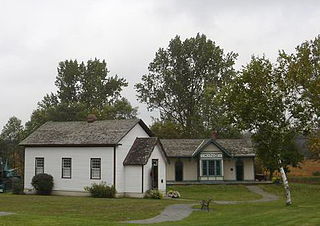
Nobleton is an unincorporated community in southwestern King, Ontario, Canada. It is the third-largest community in the township, after King City and Schomberg. Located south of the Oak Ridges Moraine, Nobleton is surrounded by hills and forests. Many horse farms are found on Nobleton's eastern periphery.

<span class="mw-page-title-main">King City, Ontario</span> Unincorporated community in Ontario, Canada

King City is an unincorporated Canadian community in the township of King, Ontario, located north of Toronto. It is the largest community in King township, with 2,730 dwellings and a population of 8,396 as of the 2021 Canadian census.

Ansnorveldt is a hamlet located at the northeastern extent of King Township, in Ontario, Canada. It is located in the Holland Marsh, north of Highway 9. Whereas most of King township is in the Oak Ridges—Markham electoral district, Ansnorveldt and all other portions of King north of Highway 9 are part of the York—Simcoe electoral district, represented federally by Scot Davidson of the Conservative Party of Canada and provincially by Caroline Mulroney of the Progressive Conservative Party of Ontario.

Pottageville is an unincorporated community located in northeastern King Township, in Ontario, Canada. It is near Schomberg. It is named for one of its early settlers, Edward Pottage.

<span class="mw-page-title-main">Ecology of the Oak Ridges Moraine</span>

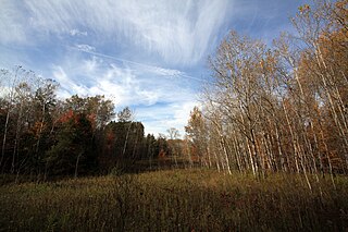
The Oak Ridges Moraine lies in Southern Ontario, Canada. It contains the headwaters of sixty-five rivers and streams. It has a wide diversity of woodlands, wetlands, watercourses, kettle lakes, kettle bogs, and significant flora and fauna. It is one of the few remaining continuous green corridors in southern Ontario: it remains thirty percent forested and is one of the last refuges for forest birds in all of southern Ontario.

<span class="mw-page-title-main">Lake Simcoe Region Conservation Authority</span>

The Lake Simcoe Region Conservation Authority is a conservation authority established in 1951, and is among the oldest in the Canadian province of Ontario.

<span class="mw-page-title-main">Cold Creek Conservation Area</span>

Cold Creek Conservation Area, usually Cold Creek, is an ecologically diverse protected Area of Natural and Scientific Interest in south-central Ontario, Canada. The 190-hectare (470-acre) conservation area was opened on 20 June 1962 by Wilf Spooner and the Toronto and Region Conservation Authority. It is located on the western end of King Township, overlapping the Oak Ridges Moraine. The Government of Ontario Ministry of Natural Resources classifies the area as a provincially significant Area of Natural and Scientific Interest for its "provincially or regionally significant representative ecological features". The area was also a site classified for the International Biological Program. The Life Science area, known as Cold Creek Swamp, is composed of a swamp and forest.

Matchedash Bay is a bay and Ramsar wetland in Simcoe County in Central Ontario, Canada. It is the "final inland extension of Severn Sound" on Lake Huron's Georgian Bay, and is "situated at the interface between the Saint Lawrence Lowlands and the Canadian Shield ". It exhibits geologically unique features at the junction of the Canadian Shield and southern Ontario limestone. Wetland habitats in Matchedash Bay are varied, and include swamps, fens, cattail marshes, wet meadows and beaver ponds. Other features include "permanent freshwater lakes; upland hardwood forest, agricultural lands, native grass meadows and a unique, coniferous wetland forest".

<span class="mw-page-title-main">Lake Wilcox</span> Body of water

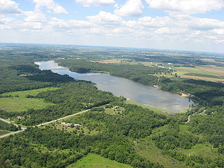
Lake Wilcox is a kettle lake in the Oak Ridges neighbourhood of Richmond Hill, Ontario, Canada. The lake measures 1.5 kilometers across and covers 55.6 hectares or 0.55 square kilometres, making it the largest kettle lake on the Oak Ridges Moraine. Lake Wilcox, Lake St. George and their associated wetlands form a "provincially significant wetland".

<span class="mw-page-title-main">Happy Valley Forest</span>

Happy Valley Forest is a 6.48 square kilometre provincially significant ecological area, classified as an Area of Natural and Scientific Interest by the Ontario Ministry of Natural Resources. It consists of an upland forest on steeply rolling topography, various wooded swamps, and minor wetland areas. A few small kettle ponds are also present.

The Glenville Hills Kames is a 345 hectare provincially significant Earth Science Area of Natural and Scientific Interest in Ontario, Canada.

The Uxbridge Forest Kames is a 644-hectare (1,591-acre) provincially significant Earth Science Area of Natural and Scientific Interest in Ontario, Canada. The land is owned and managed by the Toronto and Region Conservation Authority.

The Fleetwood Kames is a 939 hectare provincially significant Earth Science Area of Natural and Scientific Interest in Ontario, Canada. The topographical feature is located on the north slope of the Oak Ridges Moraine, in the city of Kawartha Lakes. Part of the parcel, known as Fleetwood Creek, is owned by the Ontario Heritage Foundation.

The Saugeen Kame Terraces is a 431-hectare provincially significant Earth Science Area of Natural and Scientific Interest in Ontario, Canada. It is in Grey County, bounding the eastern and southern shores of Wilder Lake, a kettle lake, and is part of the larger Singhampton Kame Moraine formation. It is a kame formation that is the result of glacial retreat sediment deposition about 14,000 years ago.

The Bennet Lake Esker Kame Complex Conservation Reserve is a Canadian conservation reserve in the townships of Boyle and Guilfoyle, in Cochrane District, Ontario. The 3,481 hectare reserve is approximately 40 km northeast of Kapuskasing.

<span class="mw-page-title-main">Habitats of the Indiana Dunes</span> Set of habitats in the United States

The Indiana Dunes comprise ten different habitats. Each provides for a unique combination of plants and animals. The range of the Indiana Dunes varies depending your source. The Indiana Lake Michigan Coastal Program uses the river drainage systems along the shoreline. This expands the area from the areas of lakeshore southward to the edges of the Valparaiso Moraine. This entire region has been dune landscapes since over 114,000 years before present (YBP). Traditionally, the Indiana Dunes area thought of as a narrow area along the shores of Lake Michigan, including the areas of Marquette Park in Gary, Indiana (1920), Indiana Dunes State Park (1926) and Indiana Dunes National Park,. The identified ten habitats can be found in these parks, where they have been preserved, but are also visible throughout the three counties of Northwest Indiana.

The Makobe River is a river in northeastern Ontario, Canada. It is in the Saint Lawrence River drainage basin, and is a left tributary of the Montreal River.

<span class="mw-page-title-main">Kiser Lake Wetlands State Nature Preserve</span>

Kiser Lake Wetlands State Nature Preserve, or simply Kiser Lake Wetlands, is a 51 acres (21 ha) nature reserve located in Johnson Township, Champaign County, Ohio, United States. It is located wholly within the Kiser Lake State Park, and operated by the Ohio Department of Natural Resources.

References

  1. "Natural Areas by Jurisdiction: King Township". Ministry of Natural Resources. Archived from the original on 2010-10-13. Retrieved 2007-08-01.
  2. "Natural Areas Report: HAPPY VALLEY FORESTS". Ministry of Natural Resources. Archived from the original on 2007-07-17. Retrieved 2007-08-01.
  3. "Natural Areas Report: POTTAGEVILLE SWAMP". Ministry of Natural Resources. Archived from the original on March 22, 2006. Retrieved 2007-08-02.
  4. "Natural Areas Report: POTTAGEVILLE SOUTHEAST UPLAND". Ministry of Natural Resources. Archived from the original on 2006-12-20. Retrieved 2007-08-02.
  5. "Natural Areas Report: COLD CREEK CONSERVATION AREA". Ministry of Natural Resources. Archived from the original on 2006-12-19. Retrieved 2007-08-02.
  6. "Natural Areas Report: LINTON-KELLY LAKE CHANNELS". Ministry of Natural Resources. Archived from the original on 2006-12-19. Retrieved 2007-08-02.
  7. "Natural Areas Report: GLENVILLE HILLS KAMES". Ministry of Natural Resources. Archived from the original on 2006-12-19. Retrieved 2007-08-02.
  8. "Natural Areas Report:KETTLEBY AND NEWMARKET TILLS". Ministry of Natural Resources. Archived from the original on 2007-08-02. Retrieved 2007-08-02.
  9. 1 2 "Natural Areas Report: EATON HALL — MARY — HACKETT LAKES WETLAND COMPLEX". Ministry of Natural Resources. Archived from the original on March 20, 2006. Retrieved 2007-08-01.
  10. "Natural Areas Report: NOBLETON WETLAND COMPLEX". Ministry of Natural Resources. Archived from the original on 2007-08-02. Retrieved 2007-08-01.
  11. "Natural Areas Report: ANSNORVELDT WETLAND COMPLEX". Ministry of Natural Resources. Archived from the original on 2006-12-19. Retrieved 2007-08-01.
  12. "Natural Areas Report: NEW SCOTLAND WETLAND COMPLEX". Ministry of Natural Resources. Archived from the original on 2006-12-19. Retrieved 2008-01-12.
  13. "Natural Areas Report: EATON HALL LAKE WETLAND". Ministry of Natural Resources. Archived from the original on 2006-12-19. Retrieved 2008-01-12.
  14. "Natural Areas Report: KING CREEK MARSH". Ministry of Natural Resources. Archived from the original on 2006-12-19. Retrieved 2008-01-12.
  15. "Natural Areas Report: KENNIFICK WETLAND COMPLEX". Ministry of Natural Resources. Retrieved 2008-01-12.[ dead link ]
  16. "Natural Areas Report: KING-VAUGHAN WETLAND COMPLEX". Ministry of Natural Resources. Archived from the original on October 22, 2005. Retrieved 2008-01-12.