Nauders

Last updated
Nauders
846 Blick-auf-Nauders.JPG
Wappen at nauders.png
Map at-7 nauders.png
Location of Nauders within Tyrol
Austria adm location map.svg
Red pog.svg
Nauders
Location within Austria
Coordinates: 46°53′33″N10°30′14″E / 46.89250°N 10.50389°E / 46.89250; 10.50389
Country Austria
State Tyrol
District Landeck
Government
   Mayor Helmut Spöttl
Area
[1]
  Total90.31 km2 (34.87 sq mi)
Elevation
1,394 m (4,573 ft)
Population
 (2018-01-01) [2]
  Total1,542
  Density17/km2 (44/sq mi)
Time zone UTC+1 (CET)
  Summer (DST) UTC+2 (CEST)
Postal code
6543
Area code 05473
Vehicle registration LA
Website www.nauders.tirol.gv.at

Nauders (Romansh : Danuder) is a municipality in the district of Landeck in the Austrian state of Tyrol.

Contents

Geography

The municipal area is situated in a high valley of the Ötztal Alps north of the Alpine crest, at an altitude of 1,394 m (4,573 ft). It is located about 29 km (18 mi) south of the district capital Landeck, on the road that leads from Pfunds in the Inntal valley via the narrow Finstermünz Gorge up to Reschen Pass and the border with the Vinschgau region in South Tyrol, Italy. Nearby is the tripoint with the Swiss border; in the west, a road leads into the Sesvenna Alps and to Martina in the Lower Engadin valley.

Climate

Climate data for Nauders (1971–2000)
MonthJanFebMarAprMayJunJulAugSepOctNovDecYear
Record high °C (°F)9.9
(49.8)
16.1
(61.0)
19.0
(66.2)
20.8
(69.4)
27.0
(80.6)
30.0
(86.0)
31.6
(88.9)
31.7
(89.1)
27.4
(81.3)
23.0
(73.4)
19.5
(67.1)
11.2
(52.2)
31.7
(89.1)
Average high °C (°F)0.5
(32.9)
2.4
(36.3)
6.2
(43.2)
9.9
(49.8)
15.2
(59.4)
18.5
(65.3)
21.3
(70.3)
20.9
(69.6)
17.2
(63.0)
11.9
(53.4)
4.9
(40.8)
0.9
(33.6)
10.8
(51.4)
Daily mean °C (°F)−4.1
(24.6)
−3.2
(26.2)
0.4
(32.7)
4.1
(39.4)
9.0
(48.2)
11.9
(53.4)
14.3
(57.7)
13.9
(57.0)
10.5
(50.9)
6.0
(42.8)
0.0
(32.0)
−3.2
(26.2)
5.0
(41.0)
Average low °C (°F)−7.6
(18.3)
−7.1
(19.2)
−3.7
(25.3)
−0.4
(31.3)
4.1
(39.4)
6.6
(43.9)
8.8
(47.8)
8.8
(47.8)
5.8
(42.4)
2.0
(35.6)
−3.3
(26.1)
−6.3
(20.7)
0.6
(33.1)
Record low °C (°F)−24.6
(−12.3)
−20.8
(−5.4)
−21.0
(−5.8)
−10.5
(13.1)
−7.8
(18.0)
−1.1
(30.0)
0.3
(32.5)
−0.3
(31.5)
−4.8
(23.4)
−10.0
(14.0)
−18.4
(−1.1)
−22.0
(−7.6)
−24.6
(−12.3)
Average precipitation mm (inches)42.3
(1.67)
36.6
(1.44)
37.5
(1.48)
35.3
(1.39)
64.8
(2.55)
84.3
(3.32)
100.0
(3.94)
91.9
(3.62)
63.7
(2.51)
49.5
(1.95)
48.6
(1.91)
41.1
(1.62)
695.6
(27.39)
Average snowfall cm (inches)43.9
(17.3)
56.3
(22.2)
36.3
(14.3)
18.4
(7.2)
3.3
(1.3)
0.1
(0.0)
0.0
(0.0)
0.4
(0.2)
0.1
(0.0)
6.5
(2.6)
27.9
(11.0)
46.5
(18.3)
239.7
(94.4)
Average precipitation days (≥ 1.0 mm)6.35.56.16.69.711.412.111.58.56.77.36.898.5
Average relative humidity (%) (at 14:00)69.259.252.251.852.252.951.554.254.356.962.066.456.5
Mean monthly sunshine hours 89.9117.9145.4149.1168.2159.8194.8192.7168.2147.694.762.11,690.4
Percent possible sunshine 51.452.049.545.645.643.752.054.355.555.145.747.849.9
Source: Central Institute for Meteorology and Geodynamics [3]

History

Naudersberg Castle Schloss naudersberg 2.JPG
Naudersberg Castle

In ancient times, the trade route across Reschen Pass was part of the Roman Via Claudia Augusta, leading from Italy across the Eastern Alps to the Raetian capital Augusta Vindelicorum (Augsburg). Nauders is probably located at the site of a mansio called Inutrium in contemporary sources. From 200 AD onwards, however, the significance of the road connection faded, when it was gradually superseded by the Brenner Pass road in the east.

The Nudres parish itself was first mentioned in an 1150 deed; from the 13th century it housed an important customs station. Over the centuries, numerous conflicts arose in the border area of the Tyrolean lands, held by the Austrian House of Habsburg from 1363, with the Swiss Confederacy, culminating in the Swabian War of 1499. Nauders, then part of the Tyrolean Vinschgau region in the south was administered from Naudersberg Castle, a medieval fortress erected in the early 14th century. In 1472 the Habsburg archduke Sigismund of Austria had the Finstermünz fortress erected in the narrow gorge of the Inn river.

Finstermunz F'munz2.jpg
Finstermünz

Finstermünz finally lost its function when a new mountain road up to the Nauders high valley was laid out according to plans by Karl von Ghega in 1854. The Austrian authorities had the Hochfinstermünz Fortress erected on the new road into the Inntal valley instead, modelled on Franzensfeste Fortress and the federal fortress in Rastatt and manned by k.k. Landesschützen detachments.

At the end of World War II, numerous Nazi officials such as Eduard Roschmann and Oswald Menghin fled on a ratline through Nauders and Reschen Pass to escape arrest.

Notable people

Related Research Articles

<span class="mw-page-title-main">Tyrol (state)</span> State of Austria

Tyrol is a state (Land) in western Austria. It comprises the Austrian part of the historical Princely County of Tyrol. It is a constituent part of the present-day Euroregion Tyrol–South Tyrol–Trentino. The capital of Tyrol is Innsbruck.

<span class="mw-page-title-main">Kufstein</span> Municipality in Tyrol, Austria

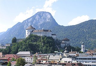
Kufstein is a town in the Austrian state of Tyrol, the administrative seat of Kufstein District. With a population of about 20,000 it is the second largest Tyrolean town after the state capital Innsbruck. The greatest landmark is Kufstein Fortress, first mentioned in the 13th century. The town was the place of origin of the Austrian noble family Kuefstein.

<span class="mw-page-title-main">Ötztal Alps</span> Mountain range in Austria and Italy

The Ötztal Alps are a mountain range in the Central Eastern Alps, in the State of Tyrol in western Austria and the Province of South Tyrol in northern Italy.

<span class="mw-page-title-main">Landeck</span> Place in Tyrol, Austria

Landeck is a city in the Austrian state of Tyrol, the capital of the district of Landeck.

<span class="mw-page-title-main">Reschen Pass</span> Mountain pass of the Alps between South Tyrol, Italy and Tyrol, Austria

Reschen Pass is a mountain pass across the main chain of the Alps, connecting the Upper Inn Valley in the northwest with the Vinschgau region in the southeast. Since 1919, the border between South Tyrol, Italy and Tyrol, Austria has approximately followed the watershed, the pass summit at a height of 1,504 metres (4,934 ft) being completely on Italian territory.

<span class="mw-page-title-main">Lofer</span> Place in Salzburg, Austria

Lofer is a market town in the district of Zell am See in the Austrian state of Salzburg.

<span class="mw-page-title-main">County of Tyrol</span> Estate of the Holy Roman Empire (1140-1806); county of Austria (1806-1919)

The (Princely) County of Tyrol was an estate of the Holy Roman Empire established about 1140. After 1253, it was ruled by the House of Gorizia and from 1363 by the House of Habsburg. In 1804, the County of Tyrol, unified with the secularised prince-bishoprics of Trent and Brixen, became a crown land of the Austrian Empire. From 1867, it was a Cisleithanian crown land of Austria-Hungary.

<span class="mw-page-title-main">Graun im Vinschgau</span> Comune in Trentino-Alto Adige/Südtirol, Italy

Graun im Vinschgau is a comune (municipality) and a village in South Tyrol in northern Italy, located about 70 kilometres (43 mi) northwest of Bolzano, on the border with Austria and Switzerland.

<span class="mw-page-title-main">Via Claudia Augusta</span> Roman road

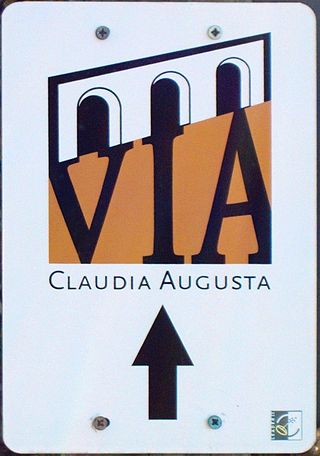
The Via Claudia Augusta is an ancient Roman road, which linked the valley of the Po River with Rhaetia across the Alps.

<span class="mw-page-title-main">Zams</span> Place in Tyrol, Austria

Zams is a municipality in the district of Landeck in the Austrian state of Tyrol.

<span class="mw-page-title-main">Lesachtal</span> Place in Carinthia, Austria

Lesachtal is a municipality in Hermagor District, in the Austrian state of Carinthia. It comprises the western part of the eponymous valley formed by the upper Gail River, and stretches from the Carinthian border with East Tyrol down to Kötschach-Mauthen in the east.

<span class="mw-page-title-main">Radstadt</span> Place in Salzburg, Austria

Radstadt is a historic town in the district of St. Johann im Pongau in the Austrian state of Salzburg.

<span class="mw-page-title-main">Oberdrauburg</span> Place in Carinthia, Austria

Oberdrauburg is a market town in the district of Spittal an der Drau at the western rim of the Austrian state of Carinthia.

<span class="mw-page-title-main">Sillian</span> Place in Tyrol, Austria

Sillian is a market town in the district of Lienz, in the Austrian state of Tyrol.

<span class="mw-page-title-main">Kaunertal</span> Place in Tyrol, Austria

The Kaunertal is a municipality and alpine valley in the Landeck district in the Austrian state of Tyrol. The municipality is located about 15 km (9.3 mi) southeast of Landeck at the upper course of the Inn river.

<span class="mw-page-title-main">Prutz</span> Place in Tyrol, Austria

Prutz is a municipality in the Landeck district in the Austrian state of Tyrol. Located at the mouth of the Kauner valley on the upper Inn, it is 10 km south of the city of Landeck and 36 km north of Reschen Pass, that forms the border to Italy. The border to Switzerland is located 23 km away towards the south-west.

<span class="mw-page-title-main">Spiss</span> Place in Tyrol, Austria

Spiss is a municipality in the district of Landeck in the Austrian state of Tyrol located 22 km south of the city of Landeck at the border of Switzerland. It is one of the smallest communities in the district. Formerly a part of Nauders, it became its own municipality in 1547. The main sources of income nowadays are tourism and agriculture.

<span class="mw-page-title-main">Biberwier</span> Place in Tyrol, Austria

Biberwier is a municipality with 612 inhabitants in the district of Reutte in the Austrian state of Tyrol. The municipality is located in the district court Reutte.

<span class="mw-page-title-main">Tyrol</span> Region across the Alps

Tyrol is a historical region in the Alps of Northern Italy and western Austria. The area was historically the core of the County of Tyrol, part of the Holy Roman Empire, Austrian Empire and Austria-Hungary, from its formation in the 12th century until 1919. In 1919, following World War I and the dissolution of Austria-Hungary, it was divided into two modern administrative parts through the Treaty of Saint-Germain-en-Laye:
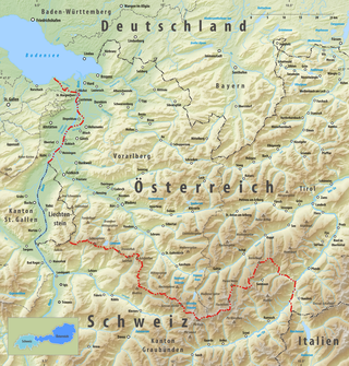
<span class="mw-page-title-main">Austro-Hungarian fortifications on the Italian border</span>

The Austro-Hungarian fortifications on the Italian border were constructed in the 19th and early 20th centuries to protect against invasion from Italy. Most were built in what is today the Trentino-Alto Adige region; some built outside this territory were ceded to Italy after 1866. By the First World War many of them were obsolete, but nevertheless played a role in deterring and containing Italian assaults.

References

  1. "Dauersiedlungsraum der Gemeinden Politischen Bezirke und Bundesländer - Gebietsstand 1.1.2018". Statistics Austria. Retrieved 10 March 2019.
  2. "Einwohnerzahl 1.1.2018 nach Gemeinden mit Status, Gebietsstand 1.1.2018". Statistics Austria. Retrieved 9 March 2019.
  3. "Klimadaten von Österreich 1971–2000 – Tirol-Nauders" (in German). Central Institute for Meteorology and Geodynamics. Archived from the original on 12 October 2019. Retrieved 31 October 2019.