Naya Nuki Peak

Last updated
Naya Nuki Peak
Naya Nuki Peak.jpg
East-southeast aspect, centered
Highest point
Elevation 9,591 ft (2,923 m) [1]
Prominence 105 ft (32 m) [1]
Parent peak Sacagawea Peak [2]
Isolation 0.43 mi (0.69 km) [2]
Coordinates 45°53′29″N110°57′45″W / 45.8912915°N 110.9625204°W / 45.8912915; -110.9625204 [3]
Geography
USA Montana relief location map.jpg
Red triangle with thick white border.svg
Naya Nuki Peak
Location in Montana
Usa edcp relief location map.png
Red triangle with thick white border.svg
Naya Nuki Peak
Location in the United States
CountryUnited States
State Montana
County Gallatin
Protected area Gallatin National Forest
Parent range Bridger Range
Rocky Mountains
Topo map USGS Sacagawea Peak
Geology
Age of rock Mississippian
Type of rock Limestone of Madison Group [4]

Naya Nuki Peak is a 9,591-foot-elevation (2,923-meter) mountain summit in Gallatin County, Montana, United States.

Contents

Description

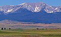
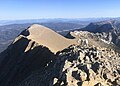
Naya Nuki Peak is the second-highest peak in the Bridger Range which is a subrange of the Rocky Mountains. [1] The peak is situated 15 miles (24 km) north of Bozeman in the Gallatin National Forest. Precipitation runoff from the mountain's east slopes drains into tributaries of the Shields River, whereas the west slope drains into tributaries of the East Gallatin River. Topographic relief is significant as the summit rises 2,000 feet (610 meters) above Fairy Lake in 0.85 miles (1.37 km) and 2,000 feet (610 meters) above North Fork Brackett Creek in 0.75 miles (1.21 km). This mountain's toponym was officially adopted in 1987 by the United States Board on Geographic Names as proposed by Bozeman school child Kristin Anderson to honor the real-life Shoshoni girl named Naya Nuki who was a friend of Sacagawea, the Shoshone Indian scout on the Lewis and Clark Expedition. [3] [5] [6] Both Naya Nuki and Sacagawea were kidnapped in a raid, but Naya Nuki escaped captivity and travelled alone 1,000 miles to return to her tribe. Naya Nuki Peak is located less than one-half mile immediately southeast of Sacagawea Peak.

Climate

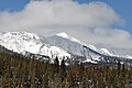
According to the Köppen climate classification system, the mountain is located in an alpine subarctic climate zone with long, cold, snowy winters, and cool to warm summers. [7] Winter temperatures can drop below 0 °F with wind chill factors below −10 °F. Due to its altitude, it receives precipitation all year, as snow in winter and as thunderstorms in summer.

See also

Related Research Articles

<span class="mw-page-title-main">Bridger Range</span> Mountain range in the U.S. state of Montana

The Bridger Range, also known as the Bridger Mountains, is a subrange of the Rocky Mountains in southwestern Montana in the United States. The range runs mostly in a north–south direction between Bozeman and Maudlow. It is separated from the Gallatin Range to the south by Bozeman Pass; from the Horseshoe Hills to the west by Dry Creek; from the Crazy Mountains to the east by the Shields River valley; and from the Big Belt Mountains to the north by Sixteen Mile Creek. The highest point in the Bridger Range is Sacagawea Peak, which is visible to the northeast from Bozeman.

<span class="mw-page-title-main">Bannock Peak</span> Mountain in Wyoming, United States

Bannock Peak is a 10,329-foot (3,148-metre) mountain summit in the southern section of the Gallatin Range in Yellowstone National Park, in the U.S. state of Wyoming. The peak ranks as the sixth-highest peak in the Gallatin Range. Precipitation runoff from the mountain drains west into headwaters of the Gallatin River and east into Panther Creek which is a tributary of the Gardner River. Topographic relief is significant as the summit rises nearly 2,000 feet above Panther Creek in one mile (1.6 km). This mountain's toponym was officially adopted in 1897 by the United States Board on Geographic Names.

<span class="mw-page-title-main">Coxcomb Peak (Colorado)</span> Mountain in the state of Colorado

Coxcomb Peak is a 13,656-foot-elevation (4,162-meter) mountain summit located on the common boundary of Hinsdale County and Ouray County, in Colorado, United States. It is situated nine miles northeast of the community of Ouray, in the Uncompahgre Wilderness, on land managed by Uncompahgre National Forest. It is part of the San Juan Mountains which are a subset of the Rocky Mountains, and is situated west of the Continental Divide. Coxcomb ranks as the 171st-highest peak in Colorado, and topographic relief is significant as the south aspect rises 2,000 feet above Wetterhorn Basin in approximately one mile, and 4,400 feet above Cow Creek in three miles. Neighbors include Precipice Peak 2.7 miles to the north, Redcliff one-half mile north, Matterhorn Peak 2.3 miles to the east-southeast, and nearest higher neighbor Wetterhorn Peak 1.8 mile to the southeast. The mountain's descriptive name, which has been officially adopted by the United States Board on Geographic Names, was in use since at least 1906 when Henry Gannett published it in the Gazetteer of Colorado.

<span class="mw-page-title-main">Red Crow Mountain</span> Mountain in the state of Montana

Red Crow Mountain is a 7,891-foot-elevation (2,405-meter) mountain summit located in Glacier National Park in the U.S. state of Montana. The summit is set on the border shared by Flathead County and Glacier County. It is situated on the Continental Divide so precipitation runoff from the east side of the mountain drains into Railroad Creek which is part of the Two Medicine River watershed, and the west side drains to Ole Creek, which is a tributary of Middle Fork Flathead River. It is set in the Lewis Range, 6.5 miles southwest of East Glacier Park Village. Topographic relief is significant as the east aspect rises approximately 2,000 feet in one mile. The nearest higher neighbor is Calf Robe Mountain 1.2 mile to the southeast, with Firebrand Pass forming the saddle between these two peaks.

<span class="mw-page-title-main">Cutoff Mountain</span> Mountain in the American state of Montana

Cutoff Mountain is a 10,695-foot (3,260-metre) mountain summit located in Park County, Montana.

<span class="mw-page-title-main">Lonesome Mountain</span>

Lonesome Mountain is an 11,399-foot (3,474-metre) mountain summit located in Carbon County, Montana.

<span class="mw-page-title-main">Black Mountain (Montana)</span>

Black Mountain is a 10,941-foot (3,335-metre) summit located in Park County, Montana, United States.

<span class="mw-page-title-main">Blaze Mountain</span> Mountain in United States

Blaze Mountain is a 10,384-foot (3,165-metre) summit located in Madison County, Montana, United States.

<span class="mw-page-title-main">Beehive Peak</span> Summit in Madison County, Montana, United States

Beehive Peak is a 10,740-foot (3,274-metre) summit located in Madison County, Montana, United States.

<span class="mw-page-title-main">Cedar Mountain (Montana)</span> Mountain in Madison County, Montana, United States

Cedar Mountain is a 10,780-foot (3,286-metre) summit located in Madison County, Montana, United States.

<span class="mw-page-title-main">Rock Peak</span> Mountain summit in Sanders County, Montana

Rock Peak is a 7,583-foot-elevation (2,311-meter) mountain summit in Sanders County, Montana.

<span class="mw-page-title-main">Ojibway Peak</span> Mountain in Montana, United States

Ojibway Peak is a 7,303-foot-elevation (2,226-meter) mountain summit located on the border shared by Lincoln and Sanders counties in Montana.

<span class="mw-page-title-main">Mount Delano</span> Mountain in Montana, United States

Mount Delano is a 10,159-foot (3,096-metre) mountain summit in Park County, Montana, United States.

<span class="mw-page-title-main">Boat Mountain</span> Mountain in Montana, United States

Boat Mountain is a 9,071-foot (2,765-metre) mountain summit in Gallatin County, Montana, United States.

<span class="mw-page-title-main">Como Peaks (Montana)</span> Mountain in Montana, United States

Como Peaks is a 9,624-foot-elevation (2,933-meter) mountain summit in Ravalli County, Montana, United States.

<span class="mw-page-title-main">Ross Peak</span> Mountain in Montana, United States

Ross Peak is a 9,008-foot-elevation (2,746-meter) mountain summit in Gallatin County, Montana, United States.

<span class="mw-page-title-main">Hardscrabble Peak</span> Mountain in Montana, United States

Hardscrabble Peak is a 9,571-foot-elevation (2,917-meter) mountain summit in Gallatin County, Montana, United States.

<span class="mw-page-title-main">Pomp Peak</span> Mountain in Montana, United States

Pomp Peak is a 9,576-foot-elevation (2,919-meter) mountain summit in Gallatin County, Montana, United States.

<span class="mw-page-title-main">Saddle Peak (Montana)</span> Mountain in Montana, United States

Saddle Peak is a 9,159-foot-elevation (2,792-meter) mountain summit in Gallatin County, Montana, United States.

<span class="mw-page-title-main">Mount Bole</span> Mountain in Montana, United States

Mount Bole is a 10,339-foot (3,151-metre) mountain summit in Gallatin County, Montana, United States.

References

  1. 1 2 3 "Naya Nuki Peak, Montana". Peakbagger.com. Retrieved 2024-07-27.
  2. 1 2 "Naya Nuki Peak - 9,581' MT". listsofjohn.com. Retrieved 2024-07-27.
  3. 1 2 "Naya Nuki Peak". Geographic Names Information System . United States Geological Survey, United States Department of the Interior . Retrieved 2024-07-27.
  4. Geological Survey Bulletin 611, USGS, Retrieved 2024-07-25.
  5. Naya Nuki author to climb her namesake peak, Daniel Person, August 16, 2008, Bozeman Daily Chronicle.
  6. United States Board on Geographic Names, Decisions on Geographic Names in the United States, Decision List No. 8702, 1987, page 5.
  7. Peel, M. C.; Finlayson, B. L.; McMahon, T. A. (2007). "Updated world map of the Köppen−Geiger climate classification". Hydrol. Earth Syst. Sci. 11. ISSN   1027-5606.