Near East earthquakes of 1759

Last updated

Near East earthquakes of 1759
Lebanon location map Topographic.png
Bullseye1.png
Oct 30
Bullseye1.png
Nov 25
Local date1759
DurationOctober 30, ~ 1 minute [1]
November 25, ~ 2 minutes [1]
MagnitudeOctober 30, 6.6 Ms
November 25, 7.4 Ms
EpicenterOctober 30, 33°06′N35°36′E / 33.1°N 35.6°E / 33.1; 35.6
November 25, 33°42′N35°54′E / 33.7°N 35.9°E / 33.7; 35.9
FaultYammouneh [2]
Areas affected Ottoman Syria
Max. intensity VIII (Severe) IX (Violent)
Aftershocks3 months [3]
Casualties2,000 [4]  – 20,000 [3]

The Near East earthquakes of 1759 were a series of devastating earthquakes that shook a large portion of the Levant in October and November of that year. This geographical crossroads in the Eastern Mediterranean were at the time under the rule of the Ottoman Empire (now includes portions of Syria, Lebanon, Turkey, Israel and Palestine). The ruins of Baalbek, a settlement in the Beqaa Valley of Lebanon east of the Litani River, were badly damaged. These 1759 events, along with the earlier 1202 Syria earthquake, are likely the strongest historical earthquakes in the region. [4]

Contents

Tectonic setting

The Dead Sea Transform is a 1,000 km (620 mi) long transform fault that runs from the northern end of the Red Sea along the Jordan Rift Valley to the Taurus Mountains complex in southern Turkey. The left-lateral fault zone marks the boundary of the Arabian Plate and the Sinai-Levantine block and has produced pull-apart basins that form the Dead Sea and the Sea of Galilee. The Levant fault system consists of multiple parallel faults with the dominant features being the Yammouneh and Rachaiya faults. The fault strand that produced these earthquakes is not precisely known and has been the source of much debate, but the Yammouneh fault has usually been cited as the source for the 1202 and 1759 events. [4]

Earthquake

The sequence of events in 1759 began on October 30, with the smaller of the two severe main shocks that year, causing the deaths of 2000 people in Safed and other settlements. This initial event was estimated at 6.6 on the surface wave magnitude scale and given a rating of VIII (Severe) to IX (Violent) on the Mercalli intensity scale. [5] This was followed by a more significant earthquake (7.4 and IX) on November 25 that destroyed all the villages in the Beqaa Valley. The areas that experienced damage were roughly the same for both the thirteenth and eighteenth-century earthquakes, with the cities of Nablus, Acre, Tyre, Tripoli and Hama being affected. The village of Ras Baalbek and the city of Damascus were both damaged and the shock was felt as far as Egypt. [4]

Damage

John Kitto, a writer and biblical scholar, documented details of the earthquakes in his 1841 book Palestine: the Physical Geography and Natural History of the Holy Land and listed first hand details of the events that were provided to him by the Scottish surgeon and naturalist Patrick Russell via his brother (also a doctor) and the Royal Society. Russell had worked as the physician at the British factory in Aleppo for many years, and followed his brother, Dr. Alexander Russel, in that position. [3]

The Yammouneh fault in Lebanon Lebanon tectonics.png
The Yammouneh fault in Lebanon

The first earthquake occurred at 4 am local time on October 30, and was described by Russell as severe and lasting more than a minute, and was followed ten minutes later by a less violent shock with a duration of no longer than fifteen seconds. Neither of these two events caused damage in Aleppo, which is in the northern region of Syria. Word came in later on that Damascus, in the south, experienced the same earthquakes, along with several others, and was reporting considerable damage, as was Tripoli, Sidon, and Acre, all cities along the coast. The event of November 25 took place in the evening at 7:30 pm. [1] The ground motion was described as:

... at first gently tremulous, increasing by degrees until the vibrations became more distinct, and, at the same time, so strong as to shake the walls of the houses with considerable violence; they then became more gentle, and then again more violent, and thus changed alternately several times during the shock, which lasted altogether about two minutes.

Patrick Russell, as told by John Kitto, [1]

A second slight shock was felt eight minutes later, and the following night at 9 pm there was an undulating aftershock that lasted a few seconds. Many more shocks were recorded during the following days with a 40-second event at 2 pm on the 28th. In Aleppo, people were frightened, but no one was killed and damage was slight, and in Antioch some buildings collapsed with some deaths occurring there. In Damascus however, a third of the city was in ruins, with many thousands having been killed. Many who survived there escaped to the fields to remain safe and did not return out of fear to help those in need. Tripoli sustained more damage than Aleppo; many houses collapsed and the residents took shelter in the open fields. Acre and Latakia experienced only minor damage to some of their walls, but the town of Safed, located on a hill, was totally destroyed and many of its inhabitants killed. Several slight aftershocks also occurred in December and January. [1]

The large scale temples and courts built in Baalbek during the Roman Empire had deteriorated since their construction nearly two thousand years earlier. During this stretch of time, earthquakes frequently occurred in that area, and these no doubt contributed to its dilapidated condition. Periods of active seismicity came and went, with significant events like the 551 Beirut earthquake damaging much of the Levant and including Baalbek, but other more active periods such as 1156–57, and 1159–70 were especially destructive and repairs to the walls there were made after the earthquake of 1170. [6]

The region became less active seismically between the fourteenth and seventeenth centuries, aside from a large event that was damaging to Jerusalem in 1546; the events in 1759 interrupted that relatively silent period. [6] As a result of the multiple earthquakes in 1759, most of the houses and ramparts within Baalbek were completely destroyed, with many of the temples' columns toppled as well. [7]

Aftermath

Paleoseismic investigation of the area has shown that surface faulting may have occurred during these events. The earlier and much stronger 1202 earthquake left evidence of fault displacement measuring 1.6 meters (5 ft 3 in). A more recently dated half-meter slip was also found, but it is unknown whether that movement can be attributed to either of the 1759 events or to the Galilee earthquake of 1837. [4] Further research was done in the Zebadani valley in Syria along the Serghaya fault. A half-meter high scarp was found, and after investigative trenching it was determined that the most recent previous seismic event dated to 1650, and the scarp was interpreted to be the result of one of the 1759 events, but it could not be resolved to either specific earthquake. [8]

See also

Related Research Articles

<span class="mw-page-title-main">Baalbek</span> City in Baalbek-Hermel, Lebanon

Baalbek is a city located east of the Litani River in Lebanon's Beqaa Valley, about 67 km (42 mi) northeast of Beirut. It is the capital of Baalbek-Hermel Governorate. In Greek and Roman times, Baalbek was also known as Heliopolis. In 1998, Baalbek had a population of 82,608, mostly Shia Muslims, followed by Sunni Muslims and Christians.

The 1138 Aleppo earthquake was among the deadliest earthquakes in history. Its name was taken from the city of Aleppo, in northern Syria, where the most casualties were sustained. The earthquake also caused damage and chaos to many other places in the area around Aleppo. The quake occurred on 11 October 1138 and was preceded by a smaller quake on the 10th. It is frequently listed as the third deadliest earthquake in history, following on from the Shensi and Tangshan earthquakes in China. However, the figure of 230,000 deaths reported by Ibn Taghribirdi in the fifteenth century is most likely based on a historical conflation of this earthquake with earthquakes in November 1137 on the Jazira plain and the large seismic event of 30 September 1139 in the Transcaucasian city of Ganja.

<span class="mw-page-title-main">Riyaq</span> Town in Lebanon

Rayaq - Haouch Hala, also romanized Rayak, is a Lebanese town in the Beqaa Governorate near the city of Zahlé. In the early 20th century and up to 1975 and the outbreak of the civil war, it was Lebanon's most important railway center, where the 1.05-m Beirut–Damascus line met the standard-gauge line north to Baalbek, Homs, and Aleppo. It now has an air base and a hospital. Rayak Air Base was bombed by the Israeli Air Force during the 2006 Lebanon War. The landing strip was severely damaged as a result.

<span class="mw-page-title-main">Dead Sea Transform</span> Fault system between the African and Arabian plates

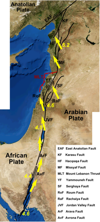
The Dead Sea Transform (DST) fault system, also sometimes referred to as the Dead Sea Rift, is a series of faults that run for about 1,000 km from the Maras Triple Junction to the northern end of the Red Sea Rift. The fault system forms the transform boundary between the African Plate to the west and the Arabian Plate to the east. It is a zone of left lateral displacement, signifying the relative motions of the two plates. Both plates are moving in a general north-northeast direction, but the Arabian Plate is moving faster, resulting in the observed left lateral motions along the fault of approximately 107 km at its southern end. A component of extension is also present in the southern part of the transform, which has contributed to a series of depressions, or pull-apart basins, forming the Gulf of Aqaba, Dead Sea, Sea of Galilee, and Hula basins. A component of shortening affects the Lebanon restraining bend, leading to uplift on both sides of the Beqaa valley. There is local transtension in the northernmost part of the fault system, forming the Ghab pull-apart basin.

<span class="mw-page-title-main">Rail transport in Lebanon</span>

Rail transport in Lebanon began in the 1890s as French projects under the Ottoman Empire but largely ceased in the 1970s owing to the country's civil war. The last remaining routes ended for economic reasons in the 1990s. At its peak Lebanon had about 408 kilometres (254 mi) of railway.

The 1202 Syria earthquake struck at about dawn on 20 May 1202 with an epicenter in southwestern Syria. The earthquake is estimated to have killed around 30,000 people. It was felt over a very wide area, from Sicily to Mesopotamia and Anatolia to upper Egypt, mostly affecting the Ayyubid Sultanate and the Kingdom of Jerusalem. The cities of Tyre, Acre and Nablus were heavily damaged. A magnitude of Ms 7.6 has been estimated with damage up to XI on the Mercalli intensity scale.

<span class="mw-page-title-main">Galilee earthquake of 1837</span> 1837 earthquake in present-day Israel

The Galilee earthquake of 1837, often called the Safed earthquake, shook the Galilee on January 1 and is one of a number of moderate to large events that have occurred along the Dead Sea Transform (DST) fault system that marks the boundary of two tectonic plates; the African Plate on the west and the Arabian Plate on the east. Intensity assessments for the event were VIII (Damaging) on the Medvedev–Sponheuer–Karnik scale and VIII on the European Macroseismic Scale.

<span class="mw-page-title-main">749 Galilee earthquake</span>

A devastating earthquake known in scientific literature as the Earthquake of 749 struck on January 18, 749, in areas of the Umayyad Caliphate, with the epicenter in Galilee. The most severely affected areas were parts of Palestine and western Transjordan. The cities of Tiberias, Beit She'an, Pella, Gadara, and Hippos were largely destroyed while many other cities across the Levant were heavily damaged. The casualties numbered in the tens of thousands.

The 1995 Gulf of Aqaba earthquake occurred on November 22 at 06:15 local time and registered 7.3 on the Mw scale. The epicenter was located in the central segment of the Gulf of Aqaba, the narrow body of water that separates Egypt's Sinai Peninsula from the western border of Saudi Arabia. At least 8 people were killed and 30 were injured in the meizoseismal area.

<span class="mw-page-title-main">551 Beirut earthquake</span> Earthquake off the Lebanese coast

The 551 Beirut earthquake occurred on 9 July with an estimated magnitude of about 7.5 on the moment magnitude scale and a maximum felt intensity of X (Extreme) on the Mercalli intensity scale. It triggered a devastating tsunami which affected the coastal towns of Byzantine Phoenicia, causing great destruction and sinking many ships. Overall large numbers of people were reported killed, with one estimate of 30,000 by the anonymous pilgrim of Piacenza for Beirut alone.

<span class="mw-page-title-main">847 Damascus earthquake</span> Earthquake affecting Syria and Lebanon

The 847 Damascus earthquake occurred in AD 847. Recent scholarship suggests that the earthquake was part of a multiple earthquake stretching from Damascus to the south, to Antioch in the north and to Mosul in the east. There were an estimated 20,000 casualties in Antioch according to the 13th-century historian and writer Al-Dhahabi, and 50,000 in Mosul. It is thought to be one of the most powerful earthquakes along the Dead Sea Transform.

The 1956 Chim earthquake was a destructive multiple-shock event that occurred on March 16 in Lebanon along a strand of the Dead Sea Transform (DST) fault system. The epicenter was located in the south of Lebanon in the Chouf District. Six thousand homes were destroyed and another 17,000 were damaged. The number of persons killed was 136.

<span class="mw-page-title-main">Yammoune</span> Village in Baalbek-Hermel, Lebanon

Yammoune is a lake, nature reserve, village and municipality situated 27 kilometres (17 mi) northwest of Baalbek in Baalbek District, Baalbek-Hermel Governorate, Lebanon. The village has a few hundred inhabitants.

<span class="mw-page-title-main">1170 Syria earthquake</span> 29 June, 1170, earthquake in Syria

The 1170 Syria earthquake was one of the largest earthquakes to hit Syria. It occurred early in the morning of 29 June 1170. It formed part of a sequence of large earthquakes that propagated southwards along the Dead Sea Transform, starting with the 1138 Aleppo earthquake, continuing with the 1157 Hama, 1170 and 1202 Syria events. The estimated magnitude is 7.7 on the moment magnitude scale, with the maximum intensity of X (Extreme) on the Mercalli intensity scale.

The 1585 Ottoman expedition against the Druze, also called the 1585 Ottoman invasion of the Shuf, was an Ottoman military campaign led by Ibrahim Pasha against the Druze and other chieftains of Mount Lebanon and its environs, then a part of the Sidon-Beirut Sanjak of the province of Damascus Eyalet. It had been traditionally considered the direct consequence of a raid by bandits in Akkar against the tribute caravan of Ibrahim Pasha, then Egypt's outgoing governor, who was on his way to Constantinople. Modern research indicates that the tribute caravan arrived intact and that the expedition was instead the culmination of Ottoman attempts to subjugate the Druze and other tribal groups in Mount Lebanon dating from 1518.

The northern part of the Ottoman Empire was struck by a major earthquake on 13 August 1822. It had an estimated magnitude of 7.0 Ms and a maximum felt intensity of IX (Destructive) on the European macroseismic scale (EMS). It may have triggered a tsunami, affecting nearby coasts. Damaging aftershocks continued for more than two years, with the most destructive being on 5 September 1822. The earthquake was felt over a large area including Rhodes, Cyprus and Gaza. The total death toll reported for this whole earthquake sequence ranges between 30,000 and 60,000, although 20,000 is regarded as a more likely number.

The 1872 Amik (Antakya) earthquake occurred on April 3 with an epicenter within the Amik Valley in the Ottoman Empire. Earthquake had an estimated magnitude of Mw  7.0–7.2 or Ms  7.2 and maximum MSK 64 rating of XI (Catastrophic). Turkey and Syria were devastated by this earthquake, and the region lost at least 1,800 residents.

<span class="mw-page-title-main">10th century in Lebanon</span> Events from the 10th century in Lebanon

This article lists historical events that occurred between 901–1000 in modern-day Lebanon or regarding its people.

A destructive earthquake affected present-day northwestern Syria and south-central Turkey in January 1344. Estimates of the seismic magnitude (Mw ) range between 6.8 and 7.6. The MSK 64 intensity was VII–VIII at Manbij; VI–VII at Aleppo and IV at Damascus. Thousands died in Syria and many structures were destroyed.

References

  1. 1 2 3 4 5 Kitto 1841, p. xc
  2. Yeats, R. S.; Sieh, K. E.; Allen, C. R. (1997). The Geology of Earthquakes. Oxford University Press. p. 480. ISBN   978-0-19-507827-5.
  3. 1 2 3 Kitto 1841, p. xlxxxix
  4. 1 2 3 4 5 Daeron et al. 2005 , p. 529
  5. Sbeinati, Mohamed Reda; Darawcheh, Ryad; Mouty, Mikhail (June 2005), "The historical earthquakes of Syria – an analysis of large and moderate earthquakes from 1365 B.C. to 1900 A.D." (PDF), Annals of Geophysics, Istituto Nazionale Geofisica e Vulcanologia, 48 (3): 381
  6. 1 2 Lewis, Norman N. (1999), "Baalbek before and after the earthquake of 1759 : the drawings of James Bruce", Levant, Maney Publishing, 31 (13): 242, doi:10.1179/lev.1999.31.1.241
  7. Alouf, Michel M. (1999). History of Baalbek. Book Tree. p. 74. ISBN   978-1585090631.
  8. Daeron et al. 2005 , p. 530
Bibliography