1033 Jordan Rift Valley earthquake

Last updated
1033 Jordan Rift Valley earthquake
Israel relief location map.jpg
Bullseye1.png
Local date5 December 1033 (1033-12-05)
Magnitude~7.3 Mw
Epicenter 32°30′N35°30′E / 32.5°N 35.5°E / 32.5; 35.5 [1]
Type Strike-slip
Areas affectedmodern-day Israel and State of Palestine
Max. intensity X (Extreme)
Casualties70,000 dead

An earthquake struck the Jordan Rift Valley on December 5, 1033 and caused extreme devastation in the Levant region. It was part of a sequence of four strong earthquakes in the region between 1033 AD and 1035 AD. Scholars have estimated the moment magnitude to be greater than 7.0 Mw and evaluated the Modified Mercalli intensity to X (Extreme). It triggered a tsunami along the Mediterranean coast, causing damage and fatalities. At least 70,000 people were killed in the disaster.

Contents

The Jordan Valley Fault (abbreviated JVF) was the source of the large earthquakes of 31 BC, 346 AD, 749 AD and 1033 AD. DeadSeaTransform.png
The Jordan Valley Fault (abbreviated JVF) was the source of the large earthquakes of 31 BC, 346 AD, 749 AD and 1033 AD.

Tectonic setting

In the past 2,000 years of human history, documented earthquakes have been associated with the 1,100 km (680 mi) long Dead Sea Transform Fault System, a left-lateral transform boundary. [2] Since the early Miocene, the fault system has accounted for between 110 km (68 mi) and 70–80 km (43–50 mi) of left-lateral displacement between the African and Arabian Plates. While left-lateral strike-slip is dominant, the fault also display features of normal and thrust faulting. The fault displays varying slip rates across its segments, 2–10 mm (0.079–0.394 in) per year. The Jordan Valley fault forms part of the larger system of faults that is collectively known as the Dead Sea Transform. This segment is 110 km (68 mi) long and trends north–south; beginning at the Dead Sea and terminating at the Sea of Galilee. [3]

Earthquake

The earthquake is thought to have ruptured the entire Jordan Valley Fault segment, based on reports of heavy damage reported from the Dead Sea to the Sea of Galilee. The historical record also showed that the pattern of damage was similar to another earthquake in AD 749. [4] Both the 749 AD and 1033 AD earthquakes ruptured the Jordan Valley Faults with magnitudes exceeding 7.0. Earlier earthquakes in 31 BC and 363 AD are thought to have been caused by the same segment rupturing. [5] Paleoseismological studies near Jericho and the Sea of Galilee revealed evidence of surface ruptures. [3] Evident in the sedimentary layers are also signs of disturbed sediments thought to be caused by the earthquake. [6]

Little research has been made to estimate the magnitude of the earthquake, and there is a great discrepancy in the range of magnitudes. A 2004 study by Migowski and others estimated the magnitude at 7.1, basing the number on the studies of disturbed sedimentary layers. Older papers also placed the magnitude as low as 6.0–6.7. [7] Most scholars however, agree with a magnitude range of 6.7–7.1. [7] [8] Earthquake magnitude catalogs prepared by researchers have also been scrutinized with its reliability and credibility questioned. [1] Italy's National Institute of Geophysics and Volcanology placed the energy magnitude (Me ) at 7.3, [9] and a recent (2020) catalog reevaluated the earthquake to a moment magnitude of 7.3 Mw. [1]

Devastation

Heavy damage was reported in a north–south trend for 190 km (120 mi) from the Dead Sea to the Sea of Galilee. One-third of the city of Ramla was destroyed. [10] Half of Nablus was destroyed and 300 residents died. The landscape around the city was also devastated. Acre experienced great damage and a high death toll. The cities of Nablus, Baniyas and Jericho also suffered the greatest destruction. A landslide buried al-Badan, a village, killing all its residents and livestock. Landslides also destroyed other villages and killed most of its population. Banias was partially destroyed. In Syria, entire villages were "swallowed" by the earth, causing fatalities. In Gaza, a mosque and the surrounding minarets collapsed. A lighthouse in the city sustained heavy damage. Reports of serious damage also came from Ascalon. Damage was reported as far away as Egypt. Sahil A. Alsinawi and others reported a death toll of 70,000. [11]

Parts of the Walls of Jerusalem collapsed and many churches were damaged. A side of the Temple Mount and the mihrab Daud, located near the Jaffa Gate collapsed. The entire southern section of the city walls which enclosed Mount Zion above the Kidron Valley, which were built by Aelia Eudocia (the fifth century wife of the Byzantine Roman emperor Theodosius II), were abandoned by Fatimid caliph Al-Zahir li-i'zaz Din Allah who established major restoration projects that lasted from 1034 AD to 1038 AD. [12] It is believed to be the largest restoration project in the city's history. The Dome of the Rock was enforced with wooden beams to strengthen the structure. Wooden beams and mosaics were added to the al-Aqsa Mosque. Solomon's Stables and al-Aqsa Mosque were among the structures that underwent restoration. [13] [12]

Shear fractures and column failures at Hisham's Palace photographed in the 1930s. Excavations at Khirbet Mefjer near Ain el-Sultan, Jericho looking N.W. showing baths LOC matpc.03717.jpg
Shear fractures and column failures at Hisham's Palace photographed in the 1930s.

Hisham's Palace was destroyed; it was previously thought that the palace was destroyed during the 749 AD earthquake, but the relatively low intensity (VII) suggest it was not the responsible earthquake. Academic studies noted fracture alignments on the ruin floor. Evidence of column and wall failures were present. Geological faulting was also found in the excavated area; the ruins displayed up to 10 cm (3.9 in) of left-lateral faulting. Human remains discovered beneath the rubble of a collapsed arch were possibly caused by the earthquake. The Modified Mercalli intensity at the palace was assigned IX–X. It is possible that the palace site was abandoned after the earthquake and occupied sometime later. [14]

A tsunami struck the coastal city of Acre. It was reported that the city port became dry for an hour, and a large wave arrived. Waves were also reported along the coast of Lebanon. Greek seismologist Nicholas Ambraseys reported that the tsunami caused no damage or casualties, but this is thought to be a confusion with the 1068 earthquake. Destruction was reported in Acre due to the tsunami. People who scoured the exposed seafloor drowned when the waves arrived. Additional shocks in April or May 1035 AD caused further damage and might be associated with tsunamis. [15]

Future threat

View of the Jordan Valley, where the earthquake occurred. Israel Jordan valley.JPG
View of the Jordan Valley, where the earthquake occurred.

The 1033 AD event was the last large earthquake on the Jordan Valley Fault. Given the estimated slip rate is 4.9 ± 0.2 mm (0.1929 ± 0.0079 in) per year, approximately 5 m (16 ft) of potential slip has been accumulated. An estimated 3.5–5 m (11–16 ft) of slip could be produced during a future earthquake along a 110 km (68 mi) × 20 km (12 mi) fault area. Such an event would suggest an earthquake of Mw 7.4, posing a great seismic threat to the region. [3]

In late 2020, researchers at Tel Aviv University said that an earthquake of magnitude 6.5 is expected to occur in the area, resulting in many fatalities. Researchers also stated that the frequency of large earthquakes in the region is significantly underestimated. [16] Previous studies suggested a recurrence interval of 10,000 years for magnitude 7.5 earthquakes, but the researchers said the figure was 1,300 to 1,400 years. [17] Yosef Shapira, the then State Comptroller of Israel, said that a major earthquake in Israel could kill up to 7,000 people if safety recommendations are not enforced. Reports of the years 2001, 2004 and 2011 found that the Israeli government did not fund any retrofitting works to old construction. Although the government said in 2008 that it would retrofit hospitals and schools, no major changes were made. [18]

See also

Related Research Articles

<span class="mw-page-title-main">Jordan Rift Valley</span> Geographic region in the Levant

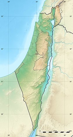
The Jordan Rift Valley, also Jordan Valley(Hebrew: בִּקְעָת הַיַרְדֵּן Bīqʿāt haYardēn, Arabic: الغور Al-Ghor or Al-Ghawr), also called the Syro-African Depression, is an elongated depression located in modern-day Israel, Jordan and the West Bank. This geographic region includes the entire length of the Jordan River – from its sources, through the Hula Valley, the Korazim block, the Sea of Galilee, the (Lower) Jordan Valley, all the way to the Dead Sea, the lowest land elevation on Earth – and then continues through the Arabah depression, the Gulf of Aqaba whose shorelines it incorporates, until finally reaching the Red Sea proper at the Straits of Tiran.

An earthquake struck Turkey's eastern Erzincan Province at 1:57:23 a.m. on 27 December 1939 local time with a moment magnitude of 7.8Mw and a maximum Mercalli intensity of XII (Extreme). It is the joint second most-powerful earthquake recorded in Turkey, tied with the 2023 Turkey–Syria earthquake. Only the 1668 North Anatolia earthquake was more powerful. This was one of the largest in a sequence of violent shocks to affect Turkey along the North Anatolian Fault between 1939 and 1999. Surface rupturing, with a horizontal displacement of up to 3.7 meters, occurred in a 360 km long segment of the North Anatolian Fault Zone. The earthquake was the most severe natural loss of life in Turkey in the 20th century, with 32,968 dead, and some 100,000 injured.

<span class="mw-page-title-main">Dead Sea Transform</span> Fault system between the African and Arabian plates

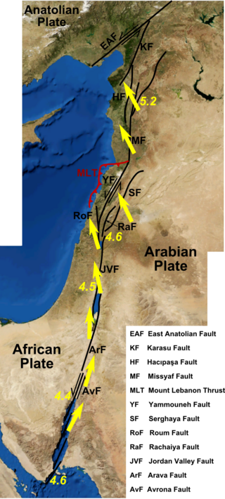
The Dead Sea Transform (DST) fault system, also sometimes referred to as the Dead Sea Rift, is a series of faults that run for about 1,000 km from the Maras Triple Junction to the northern end of the Red Sea Rift. The fault system forms the transform boundary between the African Plate to the west and the Arabian Plate to the east. It is a zone of left lateral (sinistral) displacement, signifying the relative motions of the two plates. Both plates are moving in a general north-northeast direction, but the Arabian Plate is moving faster, resulting in the observed left lateral motions along the fault of approximately 107 km at its southern end. A component of extension is also present in the southern part of the transform, which has contributed to a series of depressions, or pull-apart basins, forming the Gulf of Aqaba, Dead Sea, Sea of Galilee, and Hula basins. A component of shortening affects the Lebanon restraining bend, leading to uplift on both sides of the Beqaa valley. There is local transtension in the northernmost part of the fault system, forming the Ghab pull-apart basin. The fault system runs roughly along the political border of Israel, Jordan, and Lebanon.

The 1202 Syria earthquake struck at about dawn on 20 May 1202 with an epicenter in southwestern Syria. The earthquake is estimated to have killed around 30,000 people. It was felt over an extensive area, from Sicily to Mesopotamia and Anatolia to upper Egypt, mostly affecting the Ayyubid Sultanate and the Kingdom of Jerusalem. The cities of Tyre, Acre and Nablus were heavily damaged. A magnitude of Ms 7.6 has been estimated with damage up to XI on the Mercalli intensity scale.

The 2009 Swan Islands earthquake occurred on May 28 at 02:24:45 AM local time with a moment magnitude of 7.3 and a maximum Mercalli intensity of VII. The epicenter was located in the Caribbean Sea, 64 kilometres (40 mi) northeast of the island of Roatán, 19 miles northeast of Port Royal, Isla de Bahias, 15 miles northwest of Isla Barbaretta, and 130 kilometres (81 mi) north-northeast of La Ceiba. Three aftershocks followed the earthquake within magnitude 4 range.

The Galilee earthquake of 363 was a pair of severe earthquakes that shook the Galilee and nearby regions on May 18 and 19. The maximum perceived intensity for the events was estimated to be X on the European macroseismic scale. The earthquakes occurred on the portion of the Dead Sea Transform (DST) fault system between the Dead Sea and the Gulf of Aqaba.

The 1995 Gulf of Aqaba earthquake occurred on November 22 at 06:15 local time and registered 7.3 on the Mw scale. The epicenter was located in the central segment of the Gulf of Aqaba, the narrow body of water that separates Egypt's Sinai Peninsula from the western border of Saudi Arabia. At least 8 people were killed and 30 were injured in the meizoseismal area.

The 1881 Nicobar Islands earthquake occurred at about 07:49 local time on 31 December, with an epicentre beneath Car Nicobar. It occurred as two separate ruptures, the largest of which had an estimated magnitude of 7.9 on the moment magnitude scale and triggered a tsunami that was observed around the Bay of Bengal. It is probably the earliest earthquake for which rupture parameters have been estimated instrumentally.

<span class="mw-page-title-main">1944 Tōnankai earthquake</span> Earthquake and tsunami affecting southern Japan

The 1944 Tōnankai earthquake occurred at 13:35 local time on 7 December. It had an estimated magnitude of 8.1 on the moment magnitude scale and a maximum felt intensity of greater than 5 Shindo. It triggered a large tsunami that caused serious damage along the coast of Wakayama Prefecture and the Tōkai region. Together, the earthquake and tsunami caused 3,358 casualties.

The 1762 Arakan earthquake occurred at about 17:00 local time on 2 April, with an epicentre somewhere along the coast from Chittagong to Arakan in modern Myanmar. It had an estimated moment magnitude between 8.5 and 8.8 and a maximum estimated intensity of XI (Extreme). It triggered a local tsunami in the Bay of Bengal and caused at least 200 deaths. The earthquake was associated with major areas of both uplift and subsidence. It is also associated with a change in course of the Brahmaputra River to from east of Dhaka to 150 kilometres (93 mi) to the west via the Jamuna River.

The 1941 Andaman Islands earthquake struck the Andaman Islands on June 26 with a magnitude of 7.7 to 8.1. Details of this event are poorly known as much of Southeast Asia was in the turmoil of World War II. The quake caused severe damage in the Andaman Islands. The tsunami it triggered was reported along the Andaman and Nicobar Islands, India and British Ceylon. There may have been damage and deaths in Bangladesh, Myanmar, and Thailand due to the tsunami.

Two major earthquakes occurred in the Near East on 18 March and 29 May, AD 1068. The two earthquakes are often amalgamated by contemporary sources. The first earthquake had its epicentre somewhere in the northwestern part of the Arabian Peninsula around Tabuk, while the second was most damaging in the city of Ramla in Palestine, some 500 km to the northwest.

The 1898 Mare Island earthquake occurred in Northern California on March 30 at 23:43 local time with a moment magnitude of 5.8–6.4 and a maximum Mercalli intensity of VIII–IX (SevereViolent). Its area of perceptibility included much of northern and central California and western Nevada. Damage amounted to $350,000 and was most pronounced on Mare Island, a peninsula in northern San Francisco Bay. While relatively strong effects there were attributed to vulnerable buildings, moderate effects elsewhere in the San Francisco Bay Area consisted of damaged or partially collapsed structures, and there were media reports of a small tsunami and mostly mild aftershocks that followed.

<span class="mw-page-title-main">2018 Swan Islands earthquake</span>

On 9 January 2018, at approximately 8:51 p.m. local time, a magnitude 7.5 earthquake struck in the Yucatán Basin of the Caribbean Sea, 44 kilometres (27 mi) east of Great Swan Island off the coast of Honduras. The earthquake was felt across Central America, and rattled windows in Tegucigalpa. The earthquake was also felt in the Cayman Islands.

<span class="mw-page-title-main">1812 Ventura earthquake</span> Magnitude 7.1 earthquake in Alta California

The 1812 Ventura earthquake occurred on the morning of December 21 at 11:00 Pacific Standard Time (PST). The 7.1–7.5 magnitude earthquake, with a Modified Mercalli intensity scale rating of X (Extreme), along with its resulting tsunami, caused considerable damage to present-day Santa Barbara and Ventura County, California, which was at the time a territory of the Spanish Empire. One person was killed as a result of the earthquake while another from the aftershock. The earthquake occurred just as the region was recovering from another event on 8 December the same year. Both events are thought to have been related.

The 1872 Amik (Antakya) earthquake occurred on April 3 with an epicenter within the Amik Valley in the Ottoman Empire. Earthquake had an estimated magnitude of Mw  7.0–7.2 or Ms  7.2 and maximum MSK 64 rating of XI (Catastrophic). Turkey and Syria were devastated by this earthquake, and the region lost at least 1,800 residents.

The 1979 Saint Elias earthquake occurred near noon local time on 28 February. It measured Mw 7.4–7.6. Though the maximum recorded Modified Mercalli intensity was VII, damage was minimal and there were no casualties due to the remoteness of the faulting. The epicenter lies near the Alaskan border between the United States and Canada.

<span class="mw-page-title-main">1940 Shakotan earthquake</span> Earthquake in Japan

The 1940 Shakotan earthquake occurred on August 2 at 00:08:22 JST with a moment magnitude (Mw ) of 7.5 and maximum JMA seismic intensity of Shindo 4. The shock had an epicenter off the coast of Hokkaido, Japan. Damage from the shock was comparatively light, but the accomanying tsunami was destructive. The tsunami caused 10 deaths and 24 injuries on Hokkaido, and destroyed homes and boats across the Sea of Japan. The highest tsunami waves were recorded at the coast of Russia while along the coast of Hokkaido, waves were about 2 m.

References

  1. 1 2 3 Grigoratos, Iason; Poggi, Valerio; Danciu, Laurentiu; Rojo, Graciela (14 February 2020). "An updated parametric catalog of historical earthquakes around the Dead Sea Transform Fault Zone". Journal of Seismology. 24 (4): 803–832. Bibcode:2020JSeis..24..803G. doi:10.1007/s10950-020-09904-9. S2CID   211102430.
  2. Freund R.; Garfunkel Z.; Zak I.; Goldberg M.; Weissbrod T.; Derin B.; Bender F.; Wellings F.E.; Girdler R.W. (1970). "The Shear along the Dead Sea Rift (and Discussion)". Philosophical Transactions of the Royal Society of London. Series A, Mathematical and Physical Sciences. 267 (1181): 107–130. Bibcode:1970RSPTA.267..107F. doi:10.1098/rsta.1970.0027.
  3. 1 2 3 Ferry, Matthieu; Meghraoui, Mustapha; Karaki, Najib Abou; Al-Taj, Masdouq; Amoush, Hani; Al-Dhaisat, Salman; Barjous, Majdi (30 August 2007). "A 48-kyr-long slip rate history for the Jordan Valley segment of the Dead Sea Fault". Earth and Planetary Science Letters. 260 (3–4): 394–406. Bibcode:2007E&PSL.260..394F. doi:10.1016/j.epsl.2007.05.049.
  4. Marco S.; Hartal M.; Hazan N.; Leve L.; Stein M. (2003). "Archaeology, history, and geology of the A.D. 749 earthquake, Dead Sea transform" (PDF). Geology. 31 (8): 665–668. Bibcode:2003Geo....31..665M. doi:10.1130/G19516.1. Archived from the original (PDF) on 2015-07-09.
  5. Wechsler, Neta; Rockwell, Thomas K.; Klinger, Yann; Štěpančíková, Petra; Kanari, Mor; Marco, Shmulik; Agnon, Amotz (2014). "A Paleoseismic Record of Earthquakes for the Dead-Sea Transform Fault Between the 1st and 7th centuries CE: Non-Periodic Behavior of a Plate Boundary Fault". Bulletin of the Seismological Society of America . 104 (3). doi:10.1785/0120130304. S2CID   54590859.
  6. Migowski, Claudia; Agnon, Amotz; Bookman, Revital; Negendank, Jörg F.W; Stein, Mordechai (15 May 2004). "Recurrence pattern of Holocene earthquakes along the Dead Sea transform revealed by varve-counting and radiocarbon dating of lacustrine sediments" (PDF). Earth and Planetary Science Letters. 222 (1): 301–314. Bibcode:2004E&PSL.222..301M. doi:10.1016/j.epsl.2004.02.015.
  7. 1 2 Zohar, Motti; Salamon, Amos; Rubin, Rehav (31 January 2017). "Earthquake damage history in Israel and its close surrounding - evaluation of spatial and temporal patterns". Tectonophysics . 696–697: 1–13. Bibcode:2017Tectp.696....1Z. doi:10.1016/j.tecto.2016.12.015.
  8. Zohar, Motti; Salamon, Amos; Rubin, Rehav (16 April 2016). "Reappraised list of historical earthquakes that affected Israel and its close surroundings". Journal of Seismology. 20 (3): 971–985. Bibcode:2016JSeis..20..971Z. doi:10.1007/s10950-016-9575-7. S2CID   131324312.
  9. Guidoboni E.; Ferrari G.; Tarabusi G.; Sgattoni G.; Comastri A.; Mariotti D.; Ciuccarelli C.; Bianchi M.G.; Valensise G. (2019). "CFTI5Med, the new release of the catalogue of strong earthquakes in Italy and in the Mediterranean area". Scientific Data. 6 (1): 80. Bibcode:2019NatSD...6...80G. doi:10.1038/s41597-019-0091-9. PMC   6546750 . PMID   31160582. S2CID   174808667 . Retrieved 22 June 2022.
  10. Kallner-Amiran, D. H. (1950). "A Revised Earthquake-Catalogue of Palestine" (PDF). Israel Exploration Journal. 1 (4). Israel Exploration Society: 223–246. JSTOR   27924451.
  11. National Geophysical Data Center / World Data Service (NGDC/WDS): NCEI/WDS Global Significant Earthquake Database. NOAA National Centers for Environmental Information (1972). "Significant Earthquake Information". NOAA National Centers for Environmental Information. doi:10.7289/V5TD9V7K . Retrieved 22 June 2022.{{cite journal}}: Cite journal requires |journal= (help)
  12. 1 2 Ma'oz, Moshe; Nusseibeh, Sari, eds. (2000). Jerusalem: Points of Friction—and Beyond. The Hague, London, Boston: Kluwer Law International. pp. 136–138. ISBN   90-411-8843-6.
  13. "The Earthquake of 1033 CE". archpark.org.il. The Jerusalem Archaeological Park. Retrieved 22 June 2022.
  14. Alfonsi, Laura; Cinti, Francesca (2013). "The Kinematics of the 1033 A.D. Earthquake Revealed by the Damage at Hisham Palace (Jordan Valley, Dead Sea Transform Zone)". Seismological Research Letters. 84 (6): 997–1003. Bibcode:2013SeiRL..84..997A. doi:10.1785/0220130060.
  15. National Geophysical Data Center / World Data Service (NGDC/WDS): NCEI/WDS Global Significant Tsunami Database. NOAA National Centers for Environmental Information. "Significant Earthquake Information". NOAA National Centers for Environmental Information. doi:10.7289/V5PN93H7 . Retrieved 23 June 2022.{{cite journal}}: Cite journal requires |journal= (help)
  16. Winer, Stuart (29 December 2020). "Major earthquake, killing hundreds, likely to hit Israel in coming years – study". The Times of Israel . Retrieved 22 June 2022.
  17. Lu, Yin; Wetzler, Nadav; Waldmann, Nicolas; Agnon, Amotz; Biasi, Glenn P.; Marco, Shmuel (2020). "A 220,000-year-long continuous large earthquake record on a slow-slipping plate boundary". Science Advances. 6 (48). Bibcode:2020SciA....6.4170L. doi:10.1126/sciadv.aba4170. PMC   7695470 . PMID   33246948.
  18. "State comptroller: Israel unprepared for major quake, ignoring warnings". The Times of Israel . 18 July 2018. Retrieved 22 June 2022.