
The Mattagami River is a river in Northern Ontario, Canada.
Pakesley is a dispersed rural community and ghost town in geographic Mowat Township in the Unorganized Centre Part of Parry Sound District of Ontario, Canada. Located at the junction of Ontario Highway 522 and the Parry Sound subdivision of the Canadian Pacific Railway, it is named for the Pakeshkag River that drains the local area north to the Pickerel River. Formerly a station and passing track on the CPR, this portion of the line from Bala to Sudbury was opened to traffic June 15, 1908.
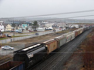
Chapleau is a township in Sudbury District, Ontario, Canada. It is home to one of the world's largest wildlife preserves. Chapleau has a population of 1,942 according to the 2016 Canadian census.
Nemegos station is a Via Rail flag stop station located at Nemegos, Ontario in the Unorganized North Part of Sudbury District in Northeastern Ontario, Canada. It is on the Canadian Pacific Railway (CPR) transcontinental main line, and is served by the regional rail Sudbury – White River train.

The Kapuskasing River is a river in the James Bay drainage basin in Cochrane District and Algoma District in northeastern Ontario, Canada. The river is a left tributary of the Mattagami River.
The Ivanhoe River is a river in Cochrane District and Sudbury District in Northeastern Ontario, Canada. The river is in the James Bay drainage basin and is a left tributary of the Groundhog River.
Tophet is an unincorporated place and railway point in geographic Mountbatten Township in the Unorganized North Part of Sudbury District in Northeastern Ontario, Canada. It is on Tophet Creek in the James Bay drainage basin.
Kinogama is an unincorporated place and railway point in geographic de Gaulle Township in the Unorganized North Part of Sudbury District in Northeastern Ontario, Canada. It is on a left tributary creek just west of the Kinogama River in the James Bay drainage basin.

The Groundhog River is a river in Cochrane District and Sudbury District in Northeastern Ontario, Canada. The river is in the James Bay drainage basin and is a left tributary of the Mattagami River.
Kapuskasing Lake is a lake in Algoma District and Sudbury District in northeastern Ontario, Canada. It is in the James Bay drainage basin and is the source of the Kapuskasing River. The majority of the lake is in geographic Kapuskasing Township, Algoma District, with just the southern tip in geographic Sherlock Township, Sudbury District.
The Chapleau River is a river in Algoma District and Sudbury District in northeastern Ontario, Canada. It is in the James Bay drainage basin, begins at Chapleau Lake and is the main tributary of Kapuskasing Lake.
The Dunrankin River is a river in Algoma District and Sudbury District in northeastern Ontario, Canada. It is in the James Bay drainage basin, begins at Upper Dunrankin Lake and is a left tributary of the Kapuskasing River.
The Swanson River is a river in Sudbury District in northeastern Ontario, Canada. It is in the James Bay drainage basin, begins south of Mageau Lake and is a left tributary of the Chapleau River.
The Makonie River is a river in Sudbury District in northeastern Ontario, Canada. It is in the James Bay drainage basin, and is a left tributary of the Chapleau River.
The East Dunrankin River is a river in Algoma District and Sudbury District in northeastern Ontario, Canada. It is in the James Bay drainage basin, and is a right tributary of the Dunrankin River.
The Kirkwall River is a river in Algoma District and Sudbury District in northeastern Ontario, Canada. It is in the James Bay drainage basin, and is a right tributary of the Dunrankin River.
The Nemegosenda River is a river in Algoma District and Sudbury District in northeastern Ontario, Canada. It is in the James Bay drainage basin, and is a right tributary of the Kapuskasing River.
Missonga is an unincorporated place and railway point in geographic Shenango Township, in the Unorganized North part of Sudbury District in northeastern Ontario, Canada. It is on the Canadian National Railway transcontinental railway main line between the railway point of Oatland to the west and the dispersed rural community of Shawmere to the east, has a railway siding, and is passed but not served by Via Rail transcontinental Canadian trains. Missonga is on Shenango Lake, at a point where Mishionga Creek leaves the lake; Mishionga Creek is a left tributary of the Shawmere River.
Shawmere is an unincorporated place and dispersed rural community in geographic Oates Township, in the Unorganized North part of Sudbury District in northeastern Ontario, Canada. It is on the Canadian National Railway transcontinental railway main line between the railway point of Missonga to the west and the compact rural community of Foleyet to the east, has a passing track, and is passed but not served by Via Rail transcontinental Canadian trains. Shawmere is on the Shawmere River, part of the James Bay drainage basin.
The Greenhill River is a river in Algoma District in northeastern Ontario, Canada. It is in the James Bay drainage basin, and is a left tributary of the Missinaibi River.
