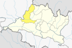
Dhading District, a part of Bagmati Province, is one of the seventy-seven districts of Nepal. The district, with Dhading Besi as its district headquarters, covers an area of 1,926 square kilometres (744 sq mi), had a population of 338,658 in 2001 and 336,067 in 2011.
Gorkha District, a part of Gandaki Province, is one of the 77 districts of Nepal, which is the fourth largest district of Nepal and connected historically with the creation of the modern Nepal and the name of the legendary Gorkha soldiers. The district, with Gorkha Municipality as its district headquarters, covers an area of 3,610 km2 (1,390 sq mi) and has a population of 252,201 according to the 2021 Nepal census. Gorkha district is the site of the Manakamana Temple. The temples of Gorakh Nath and Gorakh Kali are found in the district. Several major rivers—the Chepe, Daraudi, Marsyangdi, Budi Gandaki, and Trishuli—run through the district.

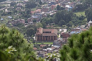
Gorkha is a municipality in Gorkha District in Gandaki Province of Nepal created in 1996. It was initially named "Prithibinarayan" after King Prithvi Narayan Shah, who was born in Gorkha and united and founded modern Nepal. In 2009, the name was changed to "Gorkha" municipality after the end of the monarchy in Nepal. At the time of the 2021 Nepal census it had a population of 53,285 people living in 12,641 individual households. In 2014, the neighboring Village development committees Nareshwar and Phinam were merged into the municipality.

Nilkantha or Neelkantha is one of two Municipalities in Dhading District in the Bagmati Province of central Nepal. The municipality is located around the center of the district and holds the majority of the population and facilities of the entire district. The municipality was established on 18 May 2014, merging with the existing places such as Nilkantha, Sunaula Bazar, Murali Bhanjyang, and Sangkosh VDC Nilkantha municipality is the most developed place of the dhading district as the economic and social conditions are greater than other parts of the district.
Thakre is a Gaupalika(Nepali: गाउपालिका ; gaupalika)(Formerly: village development committee) in Dhading District. The local body was formed by merging four VDCs namely Bhumesthan, Tasarphu, Thakre, Kebalpur and Goganpani, Bagmati. Currently, it has a total of 11 wards. The population of the rural municipality is 32,914 according to the data collected on 2017 Nepalese local elections.
Manahari is a Rural Municipality in Makwanpur District in Bagmati Province of southern Nepal. At the time of the 1991 Nepal census it had a population of 10,013 people living in 1789 individual households.
Khairahani is a municipality in Chitwan District in Bagmati Province of southern Nepal. The municipality was established on 8 May 2014 by merging the existing Khairahani, Kumroj and Chainpur VDCs. At the time of the 1991 Nepal census it had a population of 13,629 people living in 2262 households.
Kalika is a municipality in Chitwan District in the Narayani Zone of southern Nepal. This municipality was established in 2015 AD by merging the existing Jutpani, Padampur, Shaktikhor and Siddhi VDCs.
Palungtar is a municipality in Gorkha District in Gandaki Province, central Nepal. It is made up of the seven former Village Development Committees Aanppipal, Chyangli, Dhuwakot, Gaikhur, Khoplang, Mirkot and Palumtar. It lies on the bank of Marshyangdi River. The Government of Nepal plans to make Palungtar the country's first Smart City. At the time of the 2011 Nepal census it had a population of 38,174 people living in 9,924 individual households.
Rapti Municipality is a municipality which lies in Eastern part of Chitwan district in Bagmati Province of Nepal. It was formed as municipality in 2015 by merging five existing village development committees, Birendranagar VDC, Bhandara VDC, Piple VDC, Lothar VDC and Korak VDC. Total area of this municipality is 99.40 and population of this municipality according to 2068 BS census is 46510.
Khaniyabas is a Gaupalika(Nepali: गाउपालिका ; gaupalika) Formerly: village development committee) in Dhading District in the Bagmati Zone of central Nepal. It has a literacy rate of 59.22%. The local body was formed by merging three VDCs namely Jharlang, Darkha and Satyadevi. The population of the rural municipality is 12,749 according to the data collected on 2017 Nepalese local elections.
Galchhi is a Gaupalika(Nepali: गाउपालिका ; gaupalika) Formerly: village development committee) in Dhading District in the Bagmati Province of central Nepal. The local body was formed by merging three VDCs namely Baireni, Kalleri and Goganpani. Currently, it has a total of 8 wards. The population of the rural municipality is 27784 according to the data collected on 2017 Nepalese local elections.
Gangajamuna is a Gaupalika(Nepali: गाउपालिका ; gaupalika) Formerly: village development committee) in Dhading District in the Bagmati Province of central Nepal. The local body was formed by merging five VDCs namely Rigaun, Gumdi, Phulkharka, Baseri and Budhathum. Currently, it has a total of 7 wards, larger VDCS Gumdi, and Rigaun are divided in 2 wards each whereas other VDCs are divided into only one ward. The population of the rural municipality is 21,784 according to the data collected on 2017 Nepalese local elections.
Jwalamukhi is a Gaupalika(Nepali: गाउपालिका ; gaupalika) in Dhading District in the Bagmati Zone of central Nepal. The local body was formed by merging four VDCs namely Khari, Dhola, Nepal, Maidi and Chainpur, Bagmati. Currently, it has a total of 7 wards. The population of the rural municipality is 23,966 according to the data collected on 2017 Nepalese local elections.Chairman of this rural municipality is Binod Timalsina and he belongs to Nepali Congress Party.

Barpak Sulikot is a Rural Municipality in Gorkha District in the Gandaki Province of northern-central Nepal. After merging of 7 village development committee, it's called Barpak Sulikot
Benighat Rorang is a rural municipality located within the Dhading District of the Bagmati Province of Nepal. The rural municipality spans 29.17 square kilometres (11.26 sq mi), with a total population of 31,475 according to a 2011 Nepal census.
Rubi Valley is a rural municipality located within the Dhading District of the Bagmati Province of Nepal. The rural municipality spans 401.85 square kilometres (155.16 sq mi), with a total population of 9,565 according to a 2011 Nepal census.
Siddhalek is a rural municipality located within the Dhading District of the Bagmati Province of Nepal. The rural municipality spans 106.09 square kilometres (40.96 sq mi), with a total population of 23,729 according to a 2011 Nepal census.
Tripurasundari is a rural municipality located within the Dhading District of the Bagmati Province of Nepal. The rural municipality spans 271.23 square kilometres (104.72 sq mi), with a total population of 22,960 according to a 2011 Nepal census.
Bakaiya is a Rural municipality located within the Makwanpur District of the Bagmati Province of Nepal. The municipality spans 393.75 square kilometres (152.03 sq mi) of area, with a total population of 39,620 according to a 2011 Nepal census.