Geology
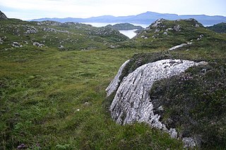
The Neuil Mine is emplaced in Neoproterozoic paragneisses of the Variscan basement of the northwestern Massif Central. The in places tightly folded paragneisses strike mainly N 130 and dip 35° to the northeast. The ore-bearing lodes crosscut the strike of the paragneisses, their orientation varying between N 045 and N 065. Their dip is generally 65° to the north. The lodes are therefore roughly parallel with the boundary fault of the Massif Central north of Saint-Pardoux-la-Rivière.
The Neoproterozoic Era is the unit of geologic time from 1,000 to 541 million years ago.

The Variscan or Hercynianorogeny is a geologic mountain-building event caused by Late Paleozoic continental collision between Euramerica (Laurussia) and Gondwana to form the supercontinent of Pangaea.
In geology, basement and crystalline basement are the rocks below a sedimentary platform or cover, or more generally any rock below sedimentary rocks or sedimentary basins that are metamorphic or igneous in origin. In the same way, the sediments or sedimentary rocks on top of the basement can be called a "cover" or "sedimentary cover".
The lodes of the Neuil Mine are no single occurrence. To the northwest (towards Nontron) several other lodes follow, which were also mined (Le Puy Mine, Cantonnier Lode, Tabataud Quarry among others).
The le Puy Mine is an ancient lead mine in the northwestern Massif Central, France. The mine produced mainly silver-bearing galena.
The Cantonnier lode formed in the Piégut-Pluviers Granodiorite, part of the basement rocks of the northwestern Massif Central in France. Its importance is highlighted by very rare mineral parageneses.
The Tabataud Quarry is situated in the northwestern French Massif Central. The quarry used to be mined for its granodiorite.
Mineralogy
The central part of the lode consists of a quartz matrix enriched more or less in baryte. The baryte can become very abundant so that it completely replaces the quartz. Abundant fractures cut through the quartz-baryte core. The sulfides galena, sphalerite and marcasite are enclosed within the quartz/baryte. The galena forms mats of octahedral crystals, the sphalerite is dense and anhedral and the marcasite powdery or displays its coxcomb habit. The lodes are mylonitized at the edges; the sulfide mineral aggregates within this zone are sheared. Secondary mineralisations cover the central fracture surfaces and the mylonitic edges. In the core region geodes of quartz and of chalcedony can occur. In the quartz geodes the habit of quartz is hexagonal-pyramidal but can show occasional bipyramids. Druses in baryte can be clad with gypsum. Apple green pyromorphite occurs forming hexagonal prisms.
The mineralisation is due to hydrothermal circulation in the temperature range 150 – 300 °C. The ores were deposited in two stages, each with a characteristic paragenesis: a higher temperature stage with galena and quartz and a lower temperature stage with baryte and marcasite. These minerals are accompanied by sphalerite, pyrite and chalcopyrite. The ore therefore belongs to the mineralisation type sphalerite-pyrite-galena-chalcopyrite.
This page is based on this
Wikipedia article Text is available under the
CC BY-SA 4.0 license; additional terms may apply.
Images, videos and audio are available under their respective licenses.

Bournonite is a sulfosalt mineral species, trithioantimoniate of lead and copper with the formula PbCuSbS3.

The Southeast Missouri Lead District, commonly called the Lead Belt, is a lead mining district in the southeastern part of Missouri. Counties in the Lead Belt include Saint Francois; Crawford; Dent; Iron; Madison: Reynolds; and Washington. Philip Francois Renault of France led a large exploratory mission in 1719 and started mining operations in Old Mines and Mine La Motte in 1720. The town of Sainte Genevieve was founded as a river port for transportation of lead out of the area. Moses Austin started large-scale mining and smelting at Potosi, originally known as Mine a Breton, and founded Herculaneum as his shipping point on the Mississippi. This lead was originally used as a roofing material. Bonne Terre has large subterranean mines, now used commercially for recreational scuba diving.

The arrondissement of Nontron is an arrondissement of France in the Dordogne department in the Nouvelle-Aquitaine region. Since the January 2017 reorganization of the arrondissements of Dordogne, it has 94 communes.
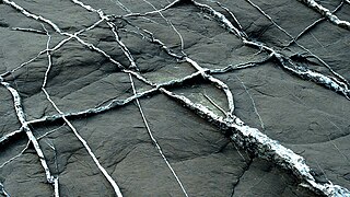
In geology, a vein is a distinct sheetlike body of crystallized minerals within a rock. Veins form when mineral constituents carried by an aqueous solution within the rock mass are deposited through precipitation. The hydraulic flow involved is usually due to hydrothermal circulation.

Saint-Martin-le-Pin is a commune in the Dordogne department in Nouvelle-Aquitaine in southwestern France. It is part of the Regional Natural Park Périgord Limousin.

Carbonate-hosted lead-zinc ore deposits are important and highly valuable concentrations of lead and zinc sulfide ores hosted within carbonate formations and which share a common genetic origin.

The Broken Hill Ore Deposit is located underneath Broken Hill in western New South Wales, Australia, and is the namesake for the town. It is arguably the world's richest and largest zinc-lead ore deposit.
Galmoy Mine is a zinc and lead mine 50 km northwest of Kilkenny, Ireland. Located in the Rathdowney Trend, Galmoy is an underground mine.
The Parc naturel régional Périgord Limousin was created March 9, 1998. It consists of 78 communes situated in the Dordogne and Haute Vienne départements. The park has a surface area of 1800 square kilometers and is inhabited by 49 661 people.
The Piégut-Pluviers Granodiorite is situated at the northwestern edge of the Variscan Massif Central in France. Its cooling age has been determined as 325 ± 14 million years BP.

Semseyite is a rarely occurring sulfosalt mineral and is part of the class of lead antimony sulfides. It crystallizes in the monoclinic system with the chemical composition Pb9Sb8S21. The mineral forms dark gray to black aggregates.

The Saint-Mathieu dome is a dome-like upwarp in the metamorphic basement of the northwestern French Massif Central. It exposes a very deep and normally hidden parautochthonous unit at the surface.
Mount Ngualla, often referred to simply as Ngualla, is a collapsed volcano located in the remote south west of Tanzania. It is approximately 200 km north of the Mbeya township.

Rampgill mine is a disused lead mine at Nenthead, Alston Moor, Cumbria, England UK Grid Reference: NY78184351

The Silberberg, at 1,358.2 m above sea level (NHN), is the most prominent summit in the mountain group around the Herzogenhorn in the Black Forest in the southwest German state of Baden-Württemberg. It lies about 4 kilometres east of the town of Todtnau.

The Nontronnais is a natural region in the northern Dordogne département and therefore part of Nouvelle-Aquitaine. It covers the surrounding of the centrally placed subprefecture Nontron. Jules Verne had called the Nontronnais Périgord vert referring to the region's lush vegetation. The term Périgord vert is used mainly in tourism, but is not identical with the Nontronnais, which covers a much smaller area.


