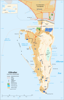
The Rock of Gibraltar, also known as the Jabel-al-Tariq, is a monolithic limestone promontory located in the territory of Gibraltar, near the southwestern tip of Europe on the Iberian Peninsula. It is 426 m (1,398 ft) high. Most of the Rock's upper area is covered by a nature reserve, which is home to around 300 Barbary macaques. These macaques, as well as a labyrinthine network of tunnels, attract many tourists each year.

Gorham's Cave is a sea-level cave in the British overseas territory of Gibraltar. Though not a sea cave, it is often mistaken for one. Considered to be one of the last known habitations of the Neanderthals in Europe, the cave gives its name to the Gorham's Cave complex, which is a combination of four distinct caves of such importance that they are combined into a UNESCO World Heritage site, the only one in Gibraltar. The three other caves are Vanguard Cave, Hyaena Cave, and Bennett's Cave.

The military history of Gibraltar during World War II exemplifies Gibraltar's position as a British fortress since the early 18th century and as a vital factor in British military strategy, both as a foothold on the continent of Europe, and as a bastion of British sea power. During World War II, Gibraltar served a vital role in both the Atlantic Theatre and the Mediterranean Theatre, controlling virtually all naval traffic into and out of the Mediterranean Sea from the Atlantic Ocean.

St. Michael's Cave or Old St. Michael's Cave is the name given to a network of limestone caves located within the Upper Rock Nature Reserve in the British Overseas Territory of Gibraltar, at a height of over 300 metres (980 ft) above sea level. According to Alonso Hernández del Portillo, the first historian of Gibraltar, its name is derived from a similar grotto in Monte Gargano near the Sanctuary of Monte Sant'Angelo in Apulia, Italy, where the archangel Michael is said to have appeared.
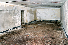
Operation Tracer was a secret Second World War military operation in Gibraltar, a British colony and military base. The impetus for the plan was the 1940 scheme by Germany to capture Gibraltar, code-named Operation Felix. Operation Tracer was the brainchild of Rear Admiral John Henry Godfrey, the Director of the Naval Intelligence Division of the Admiralty.

Green's Lodge Battery is an artillery battery in the British Overseas Territory of Gibraltar. It is located on the North Face of the Rock of Gibraltar at the northern end of the Upper Rock Nature Reserve, above Farringdon's Battery. Also known as the Superior Battery, it was named after General Sir William Green, who served in Gibraltar for twenty-two years, most of them as the chief engineer of Gibraltar. In 1776, guns were first mounted on the battery, which also saw action during the Great Siege of Gibraltar. The emplacement also underwent reconstruction in the early and mid twentieth century. Green's Lodge Battery is listed with the Gibraltar Heritage Trust.
The Gibraltar Caving Group is an organisation based in the British Overseas Territory of Gibraltar. It forms the Caves and Cliffs Section of the Gibraltar Ornithological and Natural History Society. The group of skilled cavers and climbers has multiple roles, engaging in cave exploration and research, avian rescue, and rare plant discovery. It performs surveys and clears areas with limited access. However, it is perhaps most well known for the discovery that four of its members made in December 1996. While exploring tunnels in the southern portion of the Rock of Gibraltar, they found the entrance to Operation Tracer, also known colloquially as Stay Behind Cave. Rumours of a covert World War II observation post had circulated in Gibraltar for decades. The Gibraltar Caving Group continued its exploration and evaluation of the facility under the auspices of the Gibraltar Museum.

Martin's Cave is a cave in the British Overseas Territory of Gibraltar. It opens on the eastern cliffs of the Rock of Gibraltar, below its summit at O'Hara's Battery. It is an ancient sea cave, though it is now located over 700 feet (210 m) above the shore of the Mediterranean Sea. It is only accessible because Martin's Path was constructed.

Holy Boy's Cave is a cave in the British Overseas Territory of Gibraltar. It is located on the eastern side of the Rock, near Cave S.
Leonora's Caves is a limestone cave system in the British Overseas Territory of Gibraltar. They are located within Old St. Michael's Cave.
Levant Cave is a cave in the British Overseas Territory of Gibraltar. Together with Tina's Fissure and George's Bottom Cave, Levant Cave is part of a close group of three caves at the southern end of the Upper Rock Nature Reserve.
Ragged Staff Cave is a cave bordering the harbour in the British Overseas Territory of Gibraltar. The cave was converted into Ragged Staff Magazine in 1901.

Wilson's Cave is a cave in the British Overseas Territory of Gibraltar. It was named after Major W. H. Wilson, Royal Engineers, Company Commander.

Star Chamber Cave is a limestone cave in the British Overseas Territory of Gibraltar. In the 1780s the cave became the centre of tunnels known as the Lower Galleries of the Northern Defences. In 1941 this cave was still in military use as the King's Regiment Battalion Headquarters
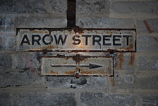
AROW Street is a tunnel in Gibraltar that was excavated in 1942. The tunnel, like Gibraltar's Great North Road, was large enough to take Army ammunition trucks.

The Great North Road is a large road tunnel in the British Overseas Territory of Gibraltar. It was constructed by the British military during World War II inside the Rock of Gibraltar and remains property of the Ministry of Defence to this day. The road allowed lorries to travel from the north to the south of Gibraltar entirely within the Rock. The tunnel still contains the remains of World War II buildings such as Nissen huts, kitchens, offices as well as a generating station and period anti-submarine nets.

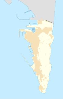
The tunnels of Gibraltar were constructed over the course of nearly 200 years, principally by the British Army. Within a land area of only 2.6 square miles (6.7 km2), Gibraltar has around 34 miles (55 km) of tunnels, nearly twice the length of its entire road network. The first tunnels, excavated in the late 18th century, served as communication passages between artillery positions and housed guns within embrasures cut into the North Face of the Rock. More tunnels were constructed in the 19th century to allow easier access to remote areas of Gibraltar and accommodate stores and reservoirs to deliver the water supply of Gibraltar.

Mediterranean Steps is a path and nature trail in the British Overseas Territory of Gibraltar. One of the footpaths of Gibraltar, the path is located entirely within the Upper Rock Nature Reserve and was built by the British military but is now used by civilians as a pedestrian route linking Martin's Path to Lord Airey's Battery near the summit of Rock of Gibraltar. The path offers views over the Strait of Gibraltar, Windmill Hill, Europa Point, the Great Sand Dune, Gibraltar's east side beaches, the Mediterranean Sea and the Spanish Costa del Sol.
Fordham's Accommodation are underground parallel chambers within the Rock of Gibraltar built during the Second World War. These are part of the extensive tunnels of Gibraltar. The chambers were named after Colonel H M Fordham OBE, MC, who was Chief Engineer in Gibraltar. The chambers were based on Liddell's Union Tunnel.
The footpaths of Gibraltar provide access to key areas of the Upper Rock Nature Reserve, a refuge for hundreds of species of flora and fauna which in some cases are found nowhere else in Europe. The reserve occupies the upper part of the Rock of Gibraltar, a long and narrow mountain that rises to a maximum height of 424 metres (1,391 ft) above sea level, and constitutes around 40 per cent of Gibraltar's total land area. The unusual geology of the Rock of Gibraltar – a limestone peak adjoining a sandstone hinterland – provides a habitat for plants and animals, such as the Gibraltar candytuft and Barbary partridge, which are found nowhere else in mainland Europe. For many years, the Upper Rock was reserved exclusively for military use; it was fenced off for military purposes, but was decommissioned and converted into a nature reserve in 1993.

