New York City Farm Colony

Last updated

The New York City Farm Colony was a poorhouse on the New York City borough of Staten Island, one of the city's five boroughs. It was located across Brielle Avenue from Seaview Hospital, on the edge of the Staten Island Greenbelt.

Contents

The New York City Farm Colony and Seaview Hospital make up their own special landmarked historic district, designated on 26 March 1985, and the site is listed on the National Register of Historic Places. [1]

History

Colonial period

Artist Axel Horn painting a mural inside the Farm Colony as part of the Federal Art Project in 1937. Image from the collection of the Archives of American Art. Archives of American Art - Axel Horr - 3001.jpg
Artist Axel Horn painting a mural inside the Farm Colony as part of the Federal Art Project in 1937. Image from the collection of the Archives of American Art.

Part of the town of Castleton from the 1680s onward, the land was previously a 96-acre farm owned by Stephen Martineau (also "Martino") of Staten Island (Dutch: Staaten Eylandt), which was previously part of New Amsterdam, the capital of New Netherland; and before that, inhabited by the Raritan band of the Unami division of the Lenape.

At the end of the Second Anglo-Dutch War in 1667, the Dutch ceded New Netherland to Kingdom of England in the Treaty of Breda, and the Dutch Staaten Eylandt, anglicized as "Staten Island", became part of the new English colony of New York.

In 1670, Native Americans, including the Lenape, ceded all claims to Staten Island to the English in a deed to Governor Francis Lovelace. In 1671, in order to encourage an expansion of the Dutch settlements, the English resurveyed Oude Dorp (which became known as 'Old Town') and expanded the lots along the shore to the south. These lots were settled primarily by Dutch families, and became known as Nieuwe Dorp (meaning 'New Village'), which later became anglicized as New Dorp.

The earliest known history of the Martineau farm goes back to April 24, 1676, when the land was granted to François Martineau ("Martino"), a French Huguenot immigrant to New Amsterdam from Île de Ré and La Rochelle, France, by the English government. King Louis XIV of France sought to impose total Catholic religious uniformity in France, repealing the Edict of Nantes, which had guaranteed religious freedom for Huguenots, in 1685. It is estimated that anywhere between 150,000 and 300,000 Protestants fled France during the wave of persecution that followed the repeal; François was one such refugee who had previously lived in the Dutch farming village of Haarlem with his family. [2]

In 1683, the colony of New York was divided into ten counties. As part of this process, Staten Island, as well as several minor neighboring islands, was designated as Richmond County. The name derives from the title of Charles Lennox, 1st Duke of Richmond, an illegitimate son of King Charles II of England and his French-born mistress, Louise de Kérouaille, Duchess of Portsmouth.

Stephen Martineau, the great-great-grandson of François Martineau, was born in 1761 on what was called the Oude Dorp (Old Town) Farm, near the northeastern shore of Staten Island. Stephen and his wife, Eleanor Haughwout, had 11 children. It was reportedly one of their daughters, Maria Martineau, who sold the farm in 1829 to the government of Richmond County for $3,000. The Richmond County Poor Farm was established on the land. [2]

Modern era

When Staten Island became a borough of New York City in 1898, the city assumed responsibility for the property and redesignated it the New York City Farm Colony, although it was sometimes also referred to as the Staten Island Farm Colony. In 1915, its administration was merged with that of Seaview Hospital, which had been set up with the expressed purpose of treating tuberculosis (it is now a city-run nursing home, under the new name of Sea View Farms). [3]

Jurisdiction over the site was transferred in 1924 to the city's Homes for Dependents agency, which lifted the requirement that all residents of the colony had to work with most of the work involving the cultivation of many varieties of fruits and vegetables, and at various times even grains such as wheat and corn; these crops fed not only the colony's residents but met the needs of other city institutions as well. [3]

For several years, the bank robber Willie Sutton, having broken prison in West Philadelphia and returned to his native New York, lived and worked at the Farm Colony, making many friends, and occasionally still carrying out robberies on the side, for which he was eventually recaptured. [4]

The interior of one of the farm's buildings in 2016. The partitions have been painted with graffiti. NYC Farm Colony 2016.jpg
The interior of one of the farm's buildings in 2016. The partitions have been painted with graffiti.

Until the 1930s, many if not most of the farm colony's residents were elderly, and at times numbered as many as 2,000; this number steadily declined after the Social Security system was adopted on the federal level in the United States (although noted photographer Alice Austen lived there for a brief period in the early 1950s [5] ), and the programs of the Great Society implemented in the 1960s further depleted its ranks, leading to the facility being closed in 1975.

Since its closure, the Farm Colony site has been the focus of debate over land use. In 1980, the city attempted to sell the property to developers, but environmentalists and many Staten Islanders resisted the sale. As a result, in 1982, the city's Department of General Services was given authority over the land; this agency in turn transferred 25 acres (10 ha) to the New York City Department of Parks and Recreation, which annexed the section to the Greenbelt. The remaining 70 acres (28 ha) at the site were officially designated a city landmark in 1985; many buildings remain standing at the colony, but have fallen into disrepair, and have also been subjected to vandalism. [3]

In 1993, a Babe Ruth League baseball diamond was built on Farm Colony land; a second field was added in 2001. The former 96-acre site is now 43 acres due to the development of ball fields, and adding sections of the property to the local green belt. [6]

A 2020 article about the property, stated that the site has been vacant for four decades, but was "being redeveloped into a multi-use complex with commercial space, and...housing options". [7] However, as of August 2022, the project appeared to be dead, with no progress made. [6]

Related Research Articles

<span class="mw-page-title-main">Staten Island</span> Borough in New York City and county in New York, United States

Staten Island is the southernmost borough of New York City, coextensive with Richmond County and situated at the southern tip of the U.S. state of New York. The borough is separated from the adjacent state of New Jersey by the Arthur Kill and the Kill Van Kull and from the rest of New York by New York Bay. With a population of 495,747 in the 2020 Census, Staten Island is the least populated New York City borough but the third largest in land area at 58.5 sq mi (152 km2); it is also the least densely populated and most suburban borough in the city.

<span class="mw-page-title-main">Staten Island Greenbelt</span> Public park in Staten Island, New York, United States

The Staten Island Greenbelt is a system of contiguous public parkland and natural areas in the central hills of the New York City borough of Staten Island. It is the second largest component of the parks owned by the government of New York City and is maintained by the city's Department of Parks and Recreation and the Greenbelt Conservancy, a not-for-profit organization that works in partnership with NYC Parks to care for the Greenbelt and raise funds for its maintenance and programs. The Greenbelt includes High Rock Park, LaTourette Park, William T. Davis Wildlife Refuge, and Willowbrook Park among others.

<span class="mw-page-title-main">New Dorp, Staten Island</span> Neighborhood of Staten Island in New York City

New Dorp is a neighborhood on the East Shore of Staten Island, New York City, United States. New Dorp is bounded by Mill Road on the southeast, Tysens Lane on the southwest, Amboy and Richmond Roads on the northwest, and Bancroft Avenue on the northeast. It is adjacent to Oakwood to the southwest, Todt Hill to the northwest, Dongan Hills and Grant City, and Midland Beach and Miller Field to the southeast. New Dorp Beach, bordering to the east, is often listed on maps as a separate neighborhood from Mill Road to the shore of Lower New York Bay, but is generally considered to be a part of New Dorp.

<span class="mw-page-title-main">Moravian Cemetery</span> Cemetery in Staten Island, New York

The Moravian Cemetery is a cemetery in the New Dorp neighborhood of Staten Island, New York, United States.

<span class="mw-page-title-main">North Shore, Staten Island</span>

The term North Shore is frequently applied to a series of neighborhoods within the New York City borough of Staten Island.

Willowbrook is a neighborhood in Staten Island, one of the five boroughs of New York City. It is located in the region of the island usually referred to as Mid-Island, immediately to the south of Port Richmond, to the west of Meiers Corners and Westerleigh, to the north of New Springville, and to the east of Bulls Head.

The history of New York City has been influenced by the prehistoric geological formation during the last glacial period of the territory that is today New York City. The area was long inhabited by the Lenape; after initial European exploration in the 16th century, the Dutch established New Amsterdam in 1626. In 1664, the British conquered the area and renamed it New York.

In the United States, a patroon was a landholder with manorial rights to large tracts of land in the 17th century Dutch colony of New Netherland on the east coast of North America. Through the Charter of Freedoms and Exemptions of 1629, the Dutch West India Company first started to grant this title and land to some of its invested members. These inducements to foster colonization and settlement are the basis for the patroon system. By the end of the eighteenth century, virtually all of the American states had abolished primogeniture and entail; thus patroons and manors evolved into simply large estates subject to division and leases.

<span class="mw-page-title-main">Pavonia, New Netherland</span> European settlement on the Hudson River

Pavonia was the first European settlement on the west bank of the North River that was part of the seventeenth-century province of New Netherland in what would become the present Hudson County, New Jersey.

<span class="mw-page-title-main">Vriessendael, New Netherland</span>

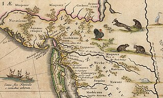
Vriessendael was a patroonship on the west bank of the Hudson River in New Netherland, the seventeenth century North American colonial province of the Dutch Empire. The homestead or plantation was located on a tract of about 500 acres (2.0 km2) about an hour's walk north of Communipaw at today's Edgewater. It has also been known as Tappan, which referred to the wider region of the New Jersey Palisades, rising above the river on both sides of the New York/New Jersey state line, and to the indigenous people who lived there and were part of wider group known as Lenape. It was established in 1640 by David Pietersen de Vries, a Dutch sea captain, explorer, and trader who had also established settlements at the Zwaanendael Colony and on Staten Island. The name can roughly be translated as De Vries' Valley. De Vries also owned flatlands along the Hackensack River, in the area named by the Dutch settlers Achter Col. Parts of Vriessendael were destroyed in 1643 in reprisal for the slaughter of Tappan and Wecquaesgeek Native Americans who had taken refuge at Pavonia and Corlears Hook. The patroon's relatively good relations with the Lenape prevented the murder of the plantation's residents, who were able to seek sanctuary in the main house, and later flee to New Amsterdam. The incident was one of the first of many to take place during Kieft's War, a series of often bloody conflicts with bands of Lenape, who had united in face of attacks ordered by the Director of New Netherland.

<span class="mw-page-title-main">Bergen, New Netherland</span> Origin of the New Jersey settlement

Bergen was a part of the 17th century province of New Netherland, in the area in northeastern New Jersey along the Hudson and Hackensack Rivers that would become contemporary Hudson and Bergen Counties. Though it only officially existed as an independent municipality from 1661, with the founding of a village at Bergen Square, Bergen began as a factory at Communipaw circa 1615 and was first settled in 1630 as Pavonia. These early settlements were along the banks of the North River across from New Amsterdam, under whose jurisdiction they fell.

Hackensack was the exonym given by the Dutch colonists to a band of the Lenape, or Lenni-Lenape, a Native American tribe. The name is a Dutch derivation of the Lenape word for what is now the region of northeastern New Jersey along the Hudson and Hackensack rivers. While the Lenape people occupied much of the mid-Atlantic area, Europeans referred to small groups of native people by the names associated with the places where they lived.

<span class="mw-page-title-main">Old Town, Staten Island</span>

Old Town is a neighborhood in the New York City borough of Staten Island, located on its East Shore. Old Town was established in August 1661 as part of New Netherland, and was the first permanent European settlement on Staten Island. Originally described as "Oude Dorpe", much of its original territory makes up what is present-day South Beach, with parts of Midland Beach and Dongan Hills. The area was settled by a group of Dutch, Walloon and French Protestants (Huguenots) led by Walloon Pierre Billiou.

<span class="mw-page-title-main">Fort Nassau (South River)</span>

Fort Nassau was a factorij in New Netherland between 1627–1651 located at the mouth of Big Timber Creek at its confluence with the Delaware River. It was the first known permanent European-built structure in what would become the state of New Jersey. The creek name is a derived from the Dutch language Timmer Kill as recorded by David Pietersen de Vries in his memoirs of his journey of 1630–1633. The Delaware Valley and its bay was called the "South River" ; the "North River" of the colony was the Hudson River. The factorij was established for the fur trade, mostly in beaver pelts, with the indigenous populations of Susquehannock, who spoke an Iroquoian language, and the Lenape, whose language was of the Algonquian family. They also wanted to retain a physical claim to the territory.

<span class="mw-page-title-main">New Netherland settlements</span> Colonial American settlements

New Netherland was the 17th century colonial province of the Republic of the Seven United Netherlands on the northeastern coast of North America. The claimed territory was the land from the Delmarva Peninsula to southern Cape Cod. The settled areas are now part of the Mid-Atlantic states of New York, New Jersey, and Delaware, with small outposts in Connecticut and Pennsylvania. Its capital of New Amsterdam was located at the southern tip of the island of Manhattan on the Upper New York Bay.

<span class="mw-page-title-main">New Netherlander</span> Historical cultural group of colonial New York, New Jersey, and Pennsylvania

New Netherlanders were residents of New Netherland, the seventeenth-century colonial province of the Republic of the Seven United Netherlands on the northeastern coast of North America, centered on the Hudson River and New York Bay, and in the Delaware Valley. Their descendants in the State of New York are the New York Dutch.

<span class="mw-page-title-main">Jan Everts Bout</span>

Jan Evertsz Bout, was an early and prominent Dutch settler in the 17th century colonial province of New Netherland.

This is a timeline of Staten Island.

References

  1. "Historic District Designation Report" (PDF). NYC.gov. Retrieved 19 September 2023.
  2. 1 2 "1887: Punch and Chico, the Photogenic Dogs of Alice Austen That Lived Where History Was Made, Part II". The Hatching Cat of Gotham. Peggy Gavan. 20 February 2017. Retrieved 8 October 2022.
  3. 1 2 3 Gray, Christopher (September 22, 1991). "Streetscapes: The Farm Colony; 'Historic' or Not, It's a Jungle in There". The New York Times . Retrieved November 26, 2008.
  4. Dunlap, David W. (20 January 2016). "New Life for Staten Island's Derelict Farm Colony". The New York Times.
  5. Raynor, Vivian (July 14, 1991). "ART; Never Without Her Camera". The New York Times . Retrieved November 26, 2008.
  6. 1 2 Liotta, Paul. "Sea View senior housing dream might be dead — no signs of progress from leaders". Staten Island Live. Retrieved 18 November 2023.
  7. "Staten Island Farm Colony". 11 October 2017. Retrieved April 8, 2021.


40°35′37″N74°08′19″W / 40.59361°N 74.13861°W / 40.59361; -74.13861