Geodesy or geodetics is the science of measuring and representing the geometry, gravity, and spatial orientation of the Earth in temporally varying 3D. It is called planetary geodesy when studying other astronomical bodies, such as planets or circumplanetary systems. Geodesy is an earth science as well as a discipline of applied mathematics, and many consider the study of Earth's shape and gravity to be central to the science.

A geographic coordinate system (GCS) is a spherical or geodetic coordinate system for measuring and communicating positions directly on Earth as latitude and longitude. It is the simplest, oldest and most widely used of the various spatial reference systems that are in use, and forms the basis for most others. Although latitude and longitude form a coordinate tuple like a cartesian coordinate system, the geographic coordinate system is not cartesian because the measurements are angles and are not on a planar surface.

Mean sea level is an average surface level of one or more among Earth's coastal bodies of water from which heights such as elevation may be measured. The global MSL is a type of vertical datum – a standardised geodetic datum – that is used, for example, as a chart datum in cartography and marine navigation, or, in aviation, as the standard sea level at which atmospheric pressure is measured to calibrate altitude and, consequently, aircraft flight levels. A common and relatively straightforward mean sea-level standard is instead a long-term average of tide gauge readings at a particular reference location.

The Ordnance Survey National Grid reference system (OSGB), also known as British National Grid (BNG), is a system of geographic grid references, distinct from latitude and longitude, whereby any location in Great Britain can be described in terms of its distance from the origin, which lies to the west of the Isles of Scilly.

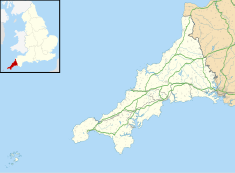
Newlyn is a seaside town and fishing port in south-west Cornwall, England, United Kingdom. It is the largest fishing port in England.

Amsterdam Ordnance Datum or Normaal Amsterdams Peil (NAP) is a vertical datum in use in large parts of Western Europe. Originally created for use in the Netherlands, its height was used by Prussia in 1879 for defining Normalnull, and in 1955 by other European countries. In the 1990s, it was used as the reference level for the United European leveling Network (UELN) which in turn led to the European Vertical Reference System (EVRS).

A tide gauge is a device for measuring the change in sea level relative to a vertical datum. It is also known as a mareograph, marigraph, and sea-level recorder. When applied to freshwater continental water bodies, the instrument may also be called a limnimeter.

The National Oceanography Centre Southampton (NOCS) is a centre for research, teaching, and technology development in Ocean and Earth science. NOCS was created in 1995, jointly between the University of Southampton and the UK Natural Environment Research Council and is located within the port of Southampton at a purpose-built dockside campus with modern facilities. In 2010 the university and NERC components demerged, and the NERC-managed component became the National Oceanography Centre. The two components of NOCS continue close collaboration through the jointly run Graduate School, shared research facilities and laboratories, complementary research groups, and many joint research grants and publications. The university component “Ocean and Earth Science, National Oceanography Centre Southampton” (OES) is part of the Faculty of Environmental and Life Sciences, (FELS). It was ranked 46th in the world for Earth and Marine Sciences by the QS World University Rankings in 2019.

The term benchmark, bench mark, or survey benchmark originates from the chiseled horizontal marks that surveyors made in stone structures, into which an angle iron could be placed to form a "bench" for a leveling rod, thus ensuring that a leveling rod could be accurately repositioned in the same place in the future. These marks were usually indicated with a chiseled arrow – specifically a broad arrow – below the horizontal line. A benchmark is a type of survey marker.
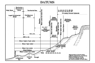
A chart datum is the water level surface serving as origin of depths displayed on a nautical chart and for reporting and predicting tide heights. A chart datum is generally derived from some tidal phase, in which case it is also known as a tidal datum. Common chart datums are lowest astronomical tide (LAT) and mean lower low water (MLLW). In non-tidal areas, e.g. the Baltic Sea, mean sea level (MSL) is used. A chart datum is a type of vertical datum and must not be confused with the horizontal datum for the chart.

An ordnance datum (OD) is a vertical datum used by an ordnance survey as the basis for deriving altitudes on maps. A spot height may be expressed as above ordnance datum (AOD). Usually mean sea level (MSL) at a particular place is used for the datum.
Established in 1985, The Global Sea Level Observing System (GLOSS) is an Intergovernmental Oceanographic Commission (IOC) program whose purpose is to measure sea level globally for long-term climate change studies. The program's purpose has changed since the 2004 Indian Ocean earthquake and the program now collects real time measurements of sea level. The project is currently upgrading the over 290 stations it currently runs, so that they can send real time data via satellite to newly set up national tsunami centres. They are also fitting the stations with solar panels so they can continue to operate even if the mains power supply is interrupted by severe weather. The Global Sea Level Observing System does not compete with Deep-ocean Assessment and Reporting of Tsunamis as most GLOSS transducers are located close to land masses while DART's transducers are far out in the ocean.
The Permanent Service for Mean Sea Level is a repository for tide gauge data used in the measurement of long-term sea level change. The PSMSL is based at the National Oceanography Centre in Liverpool, England. It was founded in 1933 as the IUGG Mean Sea Level Committee, and adopted as a Permanent Service of the International Council for Science (ICSU) in 1958.
The Australian Height Datum was introduced in 1971 as the official vertical datum for Australia, and thereby serves as the benchmark to which all height measurements are referred. The Australian Height Datum is an amalgamation of decades of spirit levelling work conducted by numerous state and territory authorities across the country, and was corrected to align with the mean sea level observations of thirty tide gauges positioned around the entire coastline. While it remains the published vertical datum for all surveying and engineering operations performed throughout Australia, newer technologies have uncovered numerous deficiencies, offsets and distortions within the Australian Height Datum, leading to discussions about defining a new Australian vertical datum.

The former Proudman Oceanographic Laboratory (POL) is based in Brownlow Street, Liverpool, England. In April 2010, POL merged with the National Oceanography Centre, Southampton (NOCS) to form the National Oceanography Centre. The Liverpool laboratory's scientific research focuses on oceanography encompassing global sea-levels and geodesy, numerical modelling of continental shelf seas and coastal sediment processes. This research alongside activities of surveying, monitoring, data management and forecasting provides strategic support for the wider mission of the Natural Environment Research Council.
The National Geodetic Vertical Datum of 1929 is the official name since 1973 of the vertical datum established for vertical control surveying in the United States of America by the General Adjustment of 1929. Originally known as Sea Level Datum of 1929, NGVD 29 was determined and published by the United States Coast and Geodetic Survey and used to measure the elevation of a point above and depression below mean sea level (MSL).
The North American Vertical Datum of 1988 is the vertical datum for orthometric heights established for vertical control surveying in the United States of America based upon the General Adjustment of the North American Datum of 1988.
In geodesy, surveying, hydrography and navigation, vertical datum or altimetric datum is a reference coordinate surface used for vertical positions, such as the elevations of Earth-bound features and altitudes of satellite orbits and in aviation. In planetary science, vertical datums are also known as zero-elevation surface or zero-level reference.
Metres above the Adriatic is the vertical datum used in Albania, Austria, Bosnia and Herzegovina, Croatia, Montenegro, North Macedonia, Serbia, and Slovenia to measure elevation, referring to the average water level of the Adriatic Sea at the Sartorio mole in the Port of Trieste.
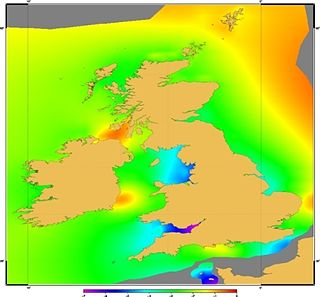
Vertical Offshore Reference Frames (VORF) is a set of high resolution surface models, published and maintained by the UK Hydrographic Office, which together define a vertical datum for hydrographic surveying and charting in the United Kingdom and Ireland.