Niue Nukutuluea Multiple-Use Marine Park

Last updated

Niue Nukutuluea Multiple-Use Marine Park
Niue EEZ division.svg
The various zones of the Niue Nukutuluea Multiple-Use Marine Park
Location Niue
Coordinates 19°30′S169°30′W / 19.500°S 169.500°W / -19.500; -169.500
Area318,140 km2 (122,830 sq mi)
EstablishedApril 2022 (2022-04)

The Niue Nukutuluea Multiple-Use Marine Park is a marine protected area that encompasses the territorial waters and exclusive economic zone surrounding the Pacific island of Niue, covering a total area of 318,140 square kilometres (122,830 sq mi). Established in April 2022, it incorporated the Niue Moana Mahu Marine Protected Area and Beveridge Reef Nukutulueatama Special Management Area, which had been established in April 2020.

Contents

The marine park is divided into five zones with differing intended uses and permitted activities. The highest level of protection surrounds the biodiverse Beveridge Reef. The park is managed through a public–private partnership, with the aim of ensuring the sustainability of its fisheries and to encourage ecotourism.

Geography

The protected area covers the entirety of Niue's ocean territory, from its coastline to the edge of its exclusive economic zone (EEZ). These waters are divided into five zones, which are subject to varying restrictions. [1] The total area of the EEZ is 318,140 square kilometres (122,830 sq mi). [2] This stretches from the 12 nautical miles (22 km; 14 mi) territorial waters baseline surrounding the island of Niue to up to 200 nautical miles (370 km; 230 mi) away. It reaches this distance to the south and southeast of Niue, where the EEZ abuts international waters. To the east a treaty defines its borders with the EEZ of the Cook Islands. To the north a treaty defines its borders with the EEZ of American Samoa. To the west, the EEZ meets the EEZ of Tonga, for which there is no treaty and a median line is assumed. [3] [4] [5]

Within this area are at least three coral reefs, the largest of which is Beveridge Reef, along with numerous seamounts. [6] Beveridge Reef lies southeast of the main island, and its Beveridge Reef Nukutulueatama Special Management Area extends for 3 nautical miles (5.6 km; 3.5 mi) around the irregularly shaped reef, an area which is defined as lying within a 10 nautical miles (19 km; 12 mi) by 11 nautical miles (20 km; 13 mi) box. The special area around Beveridge Reef falls within the Niue Moana Mahu Marine Protected Area. This almost triangular section of the EEZ is defined by lines extending from two points on the edge of the 24 nautical miles (44 km; 28 mi) contiguous zone, one going east to the border with the Cook Islands, and one going roughly south to the edge of Niue's EEZ. [7]

History

Historically, Niuean villages managed the ocean off their coastline, governing fishing through traditional practices. However, technological development led to catch rates exceeding those which could be managed sustainably through these methods. Technology also led to increased food exports, especially to overseas Niueans. As a result, fish biomass in Niue's waters decreased to regionally low levels. The Alofi North Marine Protected Area, established in the late 20th century, was depleted to the same degree as the rest of the island's waters, despite its official no-take designation. [1]

The island of Niue Niue oli 2019309 lrg.jpg
The island of Niue

In 2015 the Oceans 5 philanthropic group began working with the Niuean government to support ocean conservation, leading to the founding of the Tofia Niue NGO in 2016 and the beginning of a formal partnership between Tofia Niue and the Niuean government. [8] In September 2016, in partnership with the Government of Niue, Tofia Niue, Oceans 5, SPC and the Ridge to Reef project, National Geographic Society’s Pristine Seas project led an expedition to Niue and Beveridge Reef to conduct a comprehensive biodiversity assessment of the remote ecosystem, thereby providing critical data for the marine spatial planning process. [9] Following community consultations, the plans were officially announced in 2017, and marine spatial planning began in 2018. [8] This planning was for a management plan covering the entire EEZ. [6] The Niue Assembly established a legal basis for a marine protected area in September 2019. [8] Further funding came from the National Geographic Society, the United Nations Development Programme, and the Global Environment Facility. [10]

On 30 April 2020 the Niue Moana Mahu Marine Protected Area, including the Beveridge Reef Nukutulueatama Special Management Area, was established through legislation in the Niue Assembly. At 127,000 square kilometres (49,000 sq mi), it was at the time the second largest marine reserve after the Palau National Marine Sanctuary. [11] The size of the protected area meant Niue exceeded the Aichi Target 11 of protecting 10% of each country's waters. [2] The special protection of Beveridge Reef was driven by the importance of its links to the biodiversity around Niue island. [12] In April 2022, the wider Niue Nukutuluea Multiple-Use Marine Park was established, with its borders incorporating the previously established protected areas. [1] The government touted this as a way to not only ensure the sustainability of its national resources, but as a contribution to global efforts to tackle climate change and the Sustainable Development Goals. [13]

Biodiversity

The katuali sea snake is endemic to Niue Sea Snake Niue.jpg
The katuali sea snake is endemic to Niue

Niue's waters have not been extensively surveyed, leaving much unknown. The marine terrain has extensively varied landforms, including chasms and caves. Overall, the area exhibits relatively low productivity compared to waters around other pacific islands, as it lacks upwelling water currents that bring large amounts of nutrients to the surface. This is likely linked to relatively low fish biomass, and relatively few seabirds being present in the area. [6]

Especially in light of the area's low productivity, its ecosystems are threatened by overfishing and climate change. Cyclones have damaged shallow communities, [6] and rising temperatures have caused coral bleaching. [14]

The seafloor around Niue and Beveridge Reef is covered by a mixture of hard coral, coralline algae, Lobophora algae, turf algae, taller algae, and soft coral. This cover varies with habitat, depth, and location windward or leeward of each location. Other seafloor animals include giant clams, sea urchins, and smaller numbers of crinoids and sea cucumbers. [6]

Almost 300 shallow-water fish species are known. Total biomass is much higher at Beveridge Reef than in the shallow waters surrounding Niue, due to the large number of sharks inhabiting the reef. [6] Beveridge Reef has the world's highest concentration of grey reef sharks. [9] Other large fish found within the marine park's shallow waters include whitetip reef sharks, spotted eagle rays, marbled whiprays, red snapper, black jacks, dogtooth tuna, giant trevally, humphead wrasse, and Heller's barracuda. [6] The katuali sea snake is endemic to the area. [14] Loggerhead sea turtles, green sea turtles, and hawksbill sea turtles can be found in shallow waters. [6]

Fish that swim through the park's open waters include wahoo, mahi-mahi, yellowfin tuna, [1] mackerel scad, freckled driftfish, great barracudas, striped marlins, rainbow runners, flying fish, silky sharks, trumpetfish, cornetfish, pilot fish, and shortfin mako sharks, in addition to some species also found in shallow waters. There are 32 known fish species found in the deep sea, with grey cutthroat eels and cusk-eels being the most abundant. Other relatively abundant species are deepwater red snappers and rusty jobfish. Gamba shrimp are common near the seafloor, as are amphipods. [6]

Humpback whales breed in the waters around Niue, after migrating from Antarctica. Spinner dolphins [14] and Blainville's beaked whales are other marine mammals that have been observed within the island's waters. [6]

Governance

The marine park is governed through a unifying spatial plan that divides it into five zones of different management regimes. 40% is the Niue Moana Mahu Marine Protected Area, in which fishing, mining, and hydrocarbon and mineral exploration are prohibited. Within this area is Beveridge Reef, which is further protected through the Beveridge Reef Nukutulueatama Special Management Area, which can have additional restrictions imposed in order to preserve the reef's biodiversity. [1]

Beveridge Reef and its immediately surrounding waters are designated as a Special Management Area Beveridge Reef, Niue (ISS018-E-38813).jpg
Beveridge Reef and its immediately surrounding waters are designated as a Special Management Area

The sea within 3 nautical miles (5.6 km; 3.5 mi) of Niue's coastline is a "subsistence special management area", managed by local villages. Collecting seafood remains part of life on the island. Extending from that zone to 24 nautical miles (44 km; 28 mi) is a "restricted commercial-use zone", which permits local and charter fishing. The last zone, making up 56% of the EEZ, is a "general-use zone" where commercial fishing is permitted, although it is a less productive area of ocean and currently has no large fishing operations. Mining is also theoretically permitted in the general-use zone, although no mining activity has taken place. [1] Fines for illegal fishing can be as high as NZ$500,000 under standard procedures, with the government able to seek a larger penalty. [14]

The marine park was developed through a public-private partnership called Niue Ocean Wide, which includes representatives of the Niuean government and the Tofia Niue NGO. The island's villages each have a marine management plan for the governance of the 3-nautical-mile (5.6 km; 3.5 mi) coastal zone. Low local enforcement capacity is partially addressed through regional cooperation, with the Royal New Zealand Air Force surveying the Moana Mahu area twice a year, and patrols from the Pacific Islands Forum Fisheries Agency and Western and Central Pacific Fisheries Commission run by nearby countries (the Cook Islands, Samoa, and Tonga) also monitor Niue's waters. The government is looking to increase the use of satellite surveillance. [1]

The park is intended to stimulate eco-tourism. In addition to whale watching, tourists are permitted to swim with humpback whales. [1] Large pelagic species such as wahoo, mahi-mahi, and yellowfin tuna are caught during big-game fishing. [1] Other goals for the park include ensuring food security through sustainably managed fisheries, improving environmental health, and creating international leadership in conservation and tourism. [6]

Some funding is generated through an "Ocean Conservation Credits" scheme, which allow people to pay to protect part of the area. [1] This is intended to be an example of sustainable finance supporting the blue economy. [15]

See also

Related Research Articles

<span class="mw-page-title-main">United Nations Convention on the Law of the Sea</span> International maritime law

The United Nations Convention on the Law of the Sea (UNCLOS), also called the Law of the Sea Convention or the Law of the Sea Treaty, is an international agreement that establishes a legal framework for all marine and maritime activities. As of June 2016, 167 countries and the European Union are parties.

<span class="mw-page-title-main">Philippine Sea</span> Marginal sea east and north-east of the Philippines

The Philippine Sea is a marginal sea of the Western Pacific Ocean east of the Philippine Archipelago and the largest sea in the world, occupying an estimated surface area of 5 million square kilometers. The Philippine Sea Plate forms the floor of the sea. Its western border is the first island chain to the west, comprising the Ryukyu Islands in the northwest and Taiwan in the west. Its southwestern border comprises the Philippine islands of Luzon, Catanduanes, Samar, Leyte, and Mindanao. Its northern border comprises the Japanese islands of Honshu, Shikoku and Kyūshū. Its eastern border is the second island chain to the east, comprising the Bonin Islands and Iwo Jima in the northeast, the Mariana Islands in the due east, and Halmahera, Palau, Yap and Ulithi in the southeast. Its southern border is Indonesia's Morotai Island.

<span class="mw-page-title-main">Lord Howe Island Marine Park</span> Protected area in Australia

Lord Howe Island Marine Park is the site of Australia's and the world's most southern coral reef ecosystem. The island is 10 km in length, 2 km wide and consists of a large lagoonal reef system along its leeward side, with 28 small islets along its coast. In 1999, the waters within three nautical miles of Lord Howe Island (465.45 km2) were declared a marine park under the NSW Marine Park Act 1997 to protect its unique marine biodiversity, with the park currently being managed by the New South Wales Marine Parks Authority. Both Lord Howe Island and Balls Pyramid are incorporated within the three nautical miles protected by the state marine park. Both marine parks complement the island's status as a World Heritage Site.

<span class="mw-page-title-main">Exclusive economic zone</span> Adjacent sea zone in which a state has special rights

An exclusive economic zone (EEZ), as prescribed by the 1982 United Nations Convention on the Law of the Sea, is an area of the sea in which a sovereign state has special rights regarding the exploration and use of marine resources, including energy production from water and wind. It stretches from the outer limit of the territorial sea out to 200 nautical miles (nmi) from the coast of the state in question. It is also referred to as a maritime continental margin and, in colloquial usage, may include the continental shelf. The term does not include either the territorial sea or the continental shelf beyond the 200 nautical mile limit. The difference between the territorial sea and the exclusive economic zone is that the first confers full sovereignty over the waters, whereas the second is merely a "sovereign right" which refers to the coastal state's rights below the surface of the sea. The surface waters are international waters.

<span class="mw-page-title-main">Marine protected area</span> Protected areas of seas, oceans, estuaries or large lakes

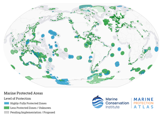
Marine protected areas (MPA) are protected areas of seas, oceans, estuaries or in the US, the Great Lakes. These marine areas can come in many forms ranging from wildlife refuges to research facilities. MPAs restrict human activity for a conservation purpose, typically to protect natural or cultural resources. Such marine resources are protected by local, state, territorial, native, regional, national, or international authorities and differ substantially among and between nations. This variation includes different limitations on development, fishing practices, fishing seasons and catch limits, moorings and bans on removing or disrupting marine life. In some situations, MPAs also provide revenue for countries, potentially equal to the income that they would have if they were to grant companies permissions to fish. The value of MPA to mobile species is unknown.

<span class="mw-page-title-main">Okinotorishima</span> Reef in the Philippine Sea

Okinotorishima, or Parece Vela, is a coral reef with two rocks enlarged with tetrapod-cement structures. It is administered by Japan with a total shoal area of 8,482 m2 and land area 9.44 m2 (101.6 sq ft). Its dry land area is mostly made up by three concrete encasings and there is a 100 by 50 m stilt platform in the lagoon housing a research station. There is a third completely artificial tetrapod-cement islet.

<span class="mw-page-title-main">Pacific Remote Islands Marine National Monument</span> Group of unorganized United States Pacific Island territories

The Pacific Remote Islands Marine National Monument is a group of unorganized, mostly unincorporated United States Pacific Island territories managed by the United States Fish and Wildlife Service of the United States Department of the Interior and the National Oceanic and Atmospheric Administration (NOAA) of the United States Department of Commerce. These remote refuges are "the most widespread collection of marine- and terrestrial-life protected areas on the planet under a single country's jurisdiction". They protect many endemic species including corals, fish, shellfish, marine mammals, seabirds, water birds, land birds, insects, and vegetation not found elsewhere.

The Australian Marine Conservation Society (AMCS) is an Australian environmental not-for-profit organisation. It was founded in 1965 as the Queensland Littoral Society before changing its name to the Australian Littoral Society and then finally in 1995 to its current title. It works on protecting the health and vitality of Australia's coasts and oceans.

<span class="mw-page-title-main">Apo Reef</span> Coral reef in the Philippines

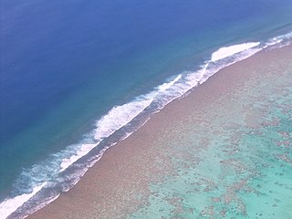
Apo Reef is a coral reef system in the Philippines situated in the western waters of Occidental Mindoro province in the Mindoro Strait. Encompassing 34 square kilometres (13 sq mi), it is considered the world's second-largest contiguous coral reef system, and is the largest in the country. The reef and its surrounding waters are protected areas administered as the Apo Reef Natural Park (ARNP). It is one of the best known and most popular diving regions in the country, and is in the tentative list for UNESCO World Heritage Sites.

<span class="mw-page-title-main">Fishing industry in New Zealand</span>

As with other countries, New Zealand’s 200 nautical miles exclusive economic zone gives its fishing industry special fishing rights. It covers 4.1 million square kilometres. This is the sixth largest zone in the world, and is fourteen times the land area of New Zealand.

<span class="mw-page-title-main">Fishing industry in the United States</span>

As with other countries, the 200 nautical miles (370 km) exclusive economic zone (EEZ) off the coast of the United States gives its fishing industry special fishing rights. It covers 11.4 million square kilometres, which is the second largest zone in the world, exceeding the land area of the United States.

<span class="mw-page-title-main">Fishing industry in the Maldives</span>

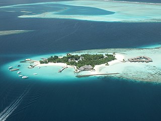
The fishing industry in the Maldives is the island's second main industry. According to national tradition in the words of former President Maumoon Abdul Gayoom, "Fishing is the lifeblood of our nation, it is inborn. From the soil on which we live, to the sea around us, it remains an integral part of our existence. Fishing, and our country and its people, [are] one and shall remain inseparable forever." The Maldives has an abundance of aquatic life and species of fish. Common are tuna, groupers, dolphin fish, barracuda, rainbow runner, trevally and squirrelfish and many more. Aside from being of essential importance to the economy, fishing is also a popular recreational activity in the Maldives, not only among locals but by tourists. The islands have numerous fishing resorts which cater for these activities.

Cape Byron Marine Park is one of four marine parks in New South Wales, Australia, and is the most recently sanctioned. The Cape Byron Marine Park is located in Northern NSW and extends 37 kilometres (23 mi) from the Brunswick River to Lennox Head. The marine park extends out to 3 nautical miles which dictates the border between state and federal jurisdiction. The marine park covers an area of 220 square kilometres (85 sq mi) and includes a variety of marine terrain including beaches, rocky shores, open ocean and the tidal waters of the Brunswick River and its tributaries, the Belongil Creek and Tallow Creek. The Cape Byron Marine Park was declared in 2002 and the zoning plan was implemented in April 2006. Of the 15 distinct marine ecosystems identified within the Tweed-Moreton bioregion, the Cape Byron Marine Park supports 10 of these.

<span class="mw-page-title-main">Marae Moana</span> Marine protected area in the Cook Islands

Marae Moana is a multiple-use marine protected area created on 13 July 2017, when the Parliament of the Cook Islands passed a bill creating the largest multiple-use marine protected area in the world at the time of its passage. Marae Moana covers the Cook Islands' entire exclusive economic zone of over 1.9 million square kilometers.

The marine protected areas of South Africa are in an area of coastline or ocean within the exclusive economic zone (EEZ) of the Republic of South Africa that is protected in terms of specific legislation for the benefit of the environment and the people who live in and use it. An MPA is a place where marine life can thrive under less pressure than unprotected areas. They are like underwater parks, and this healthy environment can benefit neighbouring areas.

<span class="mw-page-title-main">Exclusive economic zone of India</span> Economic zone exclusive to India

India has the 18th-largest exclusive economic zone (EEZ) with a total size of 2,305,143 km2 (890,021 sq mi). It includes the Lakshadweep island group in the Laccadive Sea off the southwestern coast of India and the Andaman and Nicobar Islands in the Bay of Bengal and the Andaman Sea. India's EEZ is bordered to the west by Pakistan, to the south by the Maldives and Sri Lanka and to the east by Bangladesh, Myanmar, Thailand, Malaysia and Indonesia. Based on new scientific data, India has petitioned United Nations to extend its EEZ from 200 Nautical miles to 350 miles.

<span class="mw-page-title-main">Exclusive economic zone of Canada</span>

The exclusive economic zone of Canada is the area of the sea in which Canada has special rights regarding the exploration and use of marine resources, as prescribed by the 1982 United Nations Convention on the Law of the Sea.

<span class="mw-page-title-main">Glorioso Islands Marine Natural Park</span>

The Glorioso Islands Marine Natural Park is a marine park at the entrance of the Mozambique Channel, around the Glorioso Islands, in the Indian Ocean. It extends for more than 43,000 km2 until the edge of the French overseas territory's exclusive economic zone. Established in 2012, it is the fourth marine natural park created by France and the second in the Indian Ocean after Mayotte Marine Natural Park, which it abuts.

<span class="mw-page-title-main">Mayotte Marine Natural Park</span> Marine Park in the Comoro Islands

The Mayotte Marine Natural Park is a marine park surrounding Mayotte, a French overseas region. Mayotte is part of the Comoro Islands archipelago, which lies within the Mozambique Channel in the western Indian Ocean. Established in 2010, the park covers the entirety of Mayotte's territorial waters and exclusive economic zone. It is contiguous with the Glorioso Islands Marine Natural Park, which was established two years later.

References

  1. 1 2 3 4 5 6 7 8 9 10 Evans, Monica (3 November 2022). "Small island, big ocean: Niue makes its entire EEZ a marine park". Mongabay . Retrieved 27 January 2023.
  2. 1 2 "Protection of Pacific spaces" (PDF). State of Environment and Conservation in the Pacific Islands: 2020 Regional Report (PDF). SPREP. 2021. pp. 70, 72. ISBN   978-982-04-0906-4.
  3. "Niue · MRGID 8447". Marineregions.org. Retrieved 10 February 2023.
  4. "Niue". Pacific Data Hub. Retrieved 10 February 2023.
  5. "Exclusive Economic Zone Outer Limit Notice 2013" (PDF). Cabinet of Niue. 10 September 2013. Retrieved 10 February 2023.
  6. 1 2 3 4 5 6 7 8 9 10 11 "Exploring the marine ecosystems of Niue island and Beveridge Reef" (PDF). National Geographic Society. March 2017. Retrieved 28 January 2023.
  7. "Niue Moana Mahu Marine Protected Area Regulations 2020" (PDF). Government of Niue. 30 April 2020. Retrieved 10 February 2023.
  8. 1 2 3 "Niue achieves historical marine conservation milestone". Tagata Pasifika. 29 April 2020. Retrieved 27 January 2023.
  9. 1 2 "Niue Creates Large-Scale Marine Protected Area Encompassing 40% of the Nation's EEZ: The Government of Niue and Tofia Niue, National Geographic, Oceans 5 and others are proud and excited to announce the creation of a large-scale marine protected area around Beveridge Reef and Niue". National Geographic. 5 October 2017. Retrieved 23 January 2023.
  10. "Cabinet passes the Niue Moana Mahu Marine Protected Area Regulations 2020". Television Niue. April 2020. Retrieved 27 January 2023.
  11. "Niue formalises one of largest marine reserves in world". Radio New Zealand. 30 April 2020. Retrieved 27 January 2023.
  12. "Niue declares 40% EEZ as Marine Protected Area". Pacific Ridge to Reef. 22 July 2020. Retrieved 10 February 2023.
  13. "Niue walking the talk on protecting 100% of its Ocean space" (PDF). Niuean Government. 13 April 2022. Retrieved 10 February 2023.
  14. 1 2 3 4 Turrell, Claire (30 May 2022). "Tiny Pacific island nation declares bold plan to protect 100% of its ocean". The Guardian. Retrieved 27 January 2023.
  15. Lewis, Lydia (11 July 2022). "Pacific Islands Forum: Niue's focus on climate and marine park". Radio New Zealand. Retrieved 27 January 2023.