Norman Kirk Park

Last updated

Norman Kirk Park, Kaiapoi
Norman Kirk Park 3.jpg
Areas of Norman Kirk Park – Clockwise from upper left: Kaiapoi Dog Park, Beswick Stormwater Area & The Honda Forest, Sports Fields, and Kaiapoi Community BMX Track
Norman Kirk Park
Interactive map showing location of Norman Kirk Park
TypePublic park
Location Kaiapoi
Coordinates 43°23′02″S172°39′57″E / 43.38394°S 172.66578°E / -43.38394; 172.66578 Coordinates: 43°23′02″S172°39′57″E / 43.38394°S 172.66578°E / -43.38394; 172.66578
OpenedIn stages from May 2019 to September 2020
Operated by Waimakariri District Council
StatusOpen all year

Norman Kirk Park is a recreational space on the east side of Kaiapoi which is a town in the Waimakariri District of Canterbury, New Zealand. Norman Kirk Park was built on former red zone land that was a residential neighbourhood prior to the Canterbury earthquakes of 2010 and 2011. Norman Kirk Park consists of a dog park, a nature reserve, sports fields, and a BMX track.

Contents

Name

Norman Kirk Park is named after Norman Kirk who was the mayor of Kaiapoi from 1953 until 1957. Kirk was elected to the New Zealand Parliament in 1957 and became Leader of the New Zealand Labour Party in 1964. Kirk was elected as the Prime Minister of New Zealand in 1972, a title which he held until his sudden death in 1974. [1] [2]

Norman Kirk Park inherits its name from Kirk Street Reserve which was located east of where Norman Kirk Park is today. Kirk Street Reserve was a small playground and recreational area in a neighbourhood that became a residential red zone. Kirk Street Reserve has since has had its reserve status removed and the land has been received by the Waimakariri District Council. [3] [4]

Location

Norman Kirk Park is less than one kilometre from the centre of Kaiapoi.

The boundaries of Norman Kirk Park are defined by Feldwick Drive to the north, former residential red zone land (now termed a “regeneration area”), Feldwick Drive, Cass Street, and Jollie Street to the east, Charles Street to the south, and Charles Street, former residential red zone land (now termed a “regeneration area”), Cass Street, and Feldwick Drive to the west. [4]

Norman Kirk Park is located on land that was a residential neighbourhood prior to the Canterbury earthquakes of 2010/2011. The entirety of Day Place, Cherry Vale Lane, Cookson Lane, and Beswick Street have been removed to provide land for Norman Kirk Park, along with parts of Gray Crescent, Feldwick Drive, Cass Street, Oram Place, Sewell Street, and Blackwell Crescent (which is no longer a crescent). Nandina Place, Kirk Street, and Jollie Street have minimal overlap with the new Norman Kirk Park but have also been entirely removed. [4] [5]

History

Kaiapoi East Residential Red Zone A.jpg
Photo taken on Sewell Street facing east towards Beswick Street within the former Kaiapoi east residential red zone in March 2018
The Honda Forest facing east towards the Beswick Stormwater Area.jpg
Photo taken in the Honda Forest facing east towards Beswick Stormwater Area in April 2021
Photos were taken in the same place three years apart

Prior to the 2010 Canterbury earthquake and the 2011 Christchurch earthquake the land now occupied by Norman Kirk Park was a residential neighbourhood of Kaiapoi. Earthquake damage was sufficiently severe for Canterbury Earthquake Recovery Authority (CERA) to deem the land unsuitable for rebuilding and therefore classified the area as a residential red zone. Almost all land owners agreed to voluntary buyouts amid considerable controversy, allowing the Crown to take ownership of most of the land. [6] [7] [8] [9] Housing was gradually demolished, rubble cleared away, and the land smoothed with topsoil encourage grass to grow. [10] The majority of preexisting trees remained along with unmaintained infrastructure including earthquake-damaged roads and disconnected streetlights making the land an involuntary park until October 2018. [11]

Early plan for Norman Kirk Park outlined in 'Waimakariri Residential Red Zone Recovery Plan/He Mahere Whakarauora i teWhenua Rahui o Waimakariri' in December 2016 Initial proposal by the Greater Christchurch Group for the Kaiapoi East Regeneration Area.png
Early plan for Norman Kirk Park outlined in 'Waimakariri Residential Red Zone Recovery Plan/He Mahere Whakarauora i teWhenua Rāhui o Waimakariri' in December 2016

Initial plans for what eventually became Norman Kirk Park were developed from a public engagement process entitled ‘Canvas: your thinking for the red zones’, also known as ‘Canvas’. Canvas ran from 30 July until 12 September 2016. Canvas was led by CERA and supported by the Waimakariri District Council, Ngāi Tahu, the Canterbury Regional Council, the Christchurch City Council, and the Selwyn District Council. Canvas asked locals for ideas about how the Crown could convert the residential red zone land within the Waimakariri District into public recreational, environmental, and cultural facilities. Community suggestions for land use in Kaiapoi included parks, a dog park, playgrounds, a skate park, walking and cycling tracks, sports grounds, a BMX track, community gardens, fruit forests, nature reserves with native plants, signage commemorating the streets that previously occupied the land, and for existing trees and shrubs to remain when possible. [12] The specific design of what would later become Norman Kirk Park was gradually developed through a series of discussion documents, public engagement processes, and public hearings between October 2015 and April 2016. [13] On 1 August 2016 the Waimakariri District Council submitted a ‘Draft Waimakariri Residential Red Zone Recovery Plan/Te Mahere Whakarauora mō te Whenua Rāhui o Waimakariri’ to the Greater Christchurch Group which presented the document for further public feedback in August 2016. [14] In December 2016, the Greater Christchurch Group approved the Waimakariri Residential Red Zone Recovery Plan/He Mahere Whakarauora i teWhenua Rāhui o Waimakariri. [15]

The next major development in the genesis of Norman Kirk Park took place on 15 June 2018 when the Crown officially returned the Waimakariri District residential red zone to local control by selling the land to the Waimakariri District Council for $1 and an agreement that any future profits from the land must be shared with the Crown. [16] [17] The Waimakariri District Council released a document entitled ‘Draft Reserves Master Plan: Kaiapoi Regeneration Areas’ in September 2018 which mapped out the sports fields, stormwater area, dog park, and BMX track that later formed Norman Kirk Park. This document explained that the Waimakariri District residential red zones would no longer be referred to as ‘red zones’ as they were now ‘regeneration areas’. [4] Old roads and other infrastructure were removed from the further Norman Kirk Park site in October 2018 and construction began for the creation of the sports fields and Beswick stormwater area. [11]

Norman Kirk Park received its name on 20 September 2019 with approval from the Kaiapoi-Tuahiwi Community Board. [18]

On 9 November 2019 the Waimakariri District Council was announced to be the overall winner in the 2019 Commonwealth Association of Planners (CAP) Awards for the body of work that went into producing the ‘Draft Reserves Master Plan: Kaiapoi Regeneration Areas’ document and similar work addressing the nearby The Pines Beach and Kairaki residential red zones. Judges described the project as being a model example of disaster recovery and community resilience. [19]

All areas of Norman Kirk Park were open to the public by September 2020. [20]

As of 11 April 2021, Google Street View shows how the land that became Norman Kirk Park appeared in August 2012 when the area was still an earthquake-damaged residential neighbourhood earmarked for demolition.

Future plans

The Waimakariri District Council has plans to install fitness equipment around the outside of the sports fields with distance markers along the pathway. [4]

Related Research Articles

Christchurch City in the South Island of New Zealand

Christchurch is the largest city in the South Island of New Zealand and the seat of the Canterbury Region. Christchurch lies on the South Island's east coast, just north of Banks Peninsula on Pegasus Bay. The Avon River / Ōtākaro flows through the centre of the city, with an urban park located along its banks. The city's territorial authority population is 392,100 people, and includes a number of smaller urban areas as well as rural areas. The population of the urban area is 380,600 people. Christchurch is the second-largest city by urban area population in New Zealand, after Auckland. Christchurch is the major urban area of an emerging sub-region known informally as Greater Christchurch. Notable smaller urban areas within this sub-region include Rangiora and Kaiapoi in Waimakariri District, north of the Waimakariri River, and Rolleston and Lincoln in Selwyn District to the south.

Kaiapoi Town in Canterbury, New Zealand

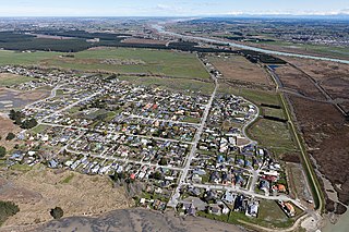
Kaiapoi is a town in the Waimakariri District of the Canterbury region, in the South Island of New Zealand. The town is located approximately 17 kilometres north of central Christchurch, close to the mouth of the Waimakariri River. It is considered to be a satellite town of Christchurch, although in the Waimakariri for statistical purposes it is part of the Christchurch urban area.

Rangiora Town in Canterbury, New Zealand

Rangiora is the largest town and seat of the Waimakariri District, in Canterbury, New Zealand. It is 29 kilometres (18 mi) north of Christchurch, and is considered a satellite town of the city. With an estimated population of 19,250, Rangiora is the 30th largest urban area in New Zealand, and the fifth-largest in the Canterbury region.

Waimakariri District Territorial authority in South Island, New Zealand

Waimakariri District is a local government district, located in the Canterbury region of New Zealand's South Island. It is named after the Waimakariri River, which forms the district's southern boundary, separating it from Christchurch City and the Selwyn District. It is bounded in the north by the Hurunui District and in the east by the Pacific Ocean.

Rolleston, New Zealand Town in South Island, New Zealand

Rolleston is the seat and largest town in the Selwyn District, in the Canterbury region of New Zealand's South Island. It is located on the Canterbury Plains 22 kilometres (14 mi) south-west of Christchurch, and is considered a satellite town of the city. The town has a population of 24,700, making it New Zealand's 26th-largest urban area and the third-largest in Canterbury. It was nicknamed the "Town of the Future" in the 1970s by Prime Minister Norman Kirk. The "Town of the Future" signage has since been removed from the entrances to Rolleston.

Kaitiaki is a New Zealand Māori term used for the concept of guardianship, for the sky, the sea, and the land. A kaitiaki is a guardian, and the process and practices of protecting and looking after the environment are referred to as kaitiakitanga.

Orion New Zealand New Zealand electric utility

Orion New Zealand Limited (Orion) is an electricity distribution company, based in Christchurch, New Zealand.

Avon River / Ōtākaro River in Christchurch, New Zealand

The Avon River / Ōtākaro flows through the centre of the city of Christchurch, New Zealand, and out to an estuary, which it shares with the Ōpāwaho / Heathcote River, the Avon Heathcote Estuary / Ihutai.

The 2010 Canterbury earthquake struck the South Island of New Zealand with a moment magnitude of 7.1 at 4:35 am local time on 4 September, and had a maximum perceived intensity of X (Extreme) on the Mercalli intensity scale. Some damaging aftershocks followed the main event, the strongest of which was a magnitude 6.3 shock known as the Christchurch earthquake that occurred nearly six months later on 22 February 2011. Because this aftershock was centred very close to Christchurch, it was much more destructive and resulted in the deaths of 185 people.

Canterbury Earthquake Recovery Authority

The Canterbury Earthquake Recovery Authority was the public service department of New Zealand charged with coordinating the rebuild of Christchurch and the surrounding areas following the 22 February 2011 earthquake. After it was disestablished on 18 April 2016, CERA's functions were taken over by a variety of other agencies.

Brooklands, Christchurch Suburb of Christchurch in Christchurch City Council, New Zealand

Brooklands is the northernmost suburb of Christchurch, New Zealand. The settlement was built on former swamp land adjacent to Brooklands Lagoon, which forms part of the Waimakariri River mouth. The land damage sustained in the 2010 and 2011 Christchurch earthquakes and subsequent Red Zone classification resulted in the buyout and demolition of nearly all properties in Brooklands, effectively wiping the suburb off the map.

Central City Red Zone

The Central City Red Zone, also known as the CBD Red Zone, was a public exclusion zone in the Christchurch Central City implemented after the 22 February 2011 Christchurch earthquake. After February 2013, it was officially renamed the CBD Rebuild Zone by government agencies, but remained known as the Red Zone. It gradually shrank in size and the last cordons were removed on 30 June 2013, 859 days after the earthquake.

Margaret Mahy Playground Playground in Christchurch, New Zealand

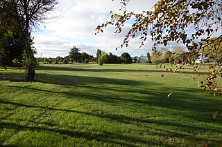
The Margaret Mahy Playground is a playground in the Christchurch Central City on the banks of the Avon River.

East Lake (New Zealand)

East Lake is an open water course under consideration in Christchurch, New Zealand. The facility, located within the residential red zone adjacent to the Avon River, would be suitable for international rowing regattas. The facility is estimated at NZ$160m to construct.

Residential red zone

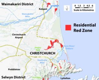
The residential red zone refers to areas of land in and around Christchurch, New Zealand, that experienced severe damage in the 2010 and 2011 Christchurch earthquakes and were deemed infeasible to rebuild on. Through voluntary buyouts, the Crown acquired and demolished or removed over 8,000 properties. The majority were located in a broad swath of the eastern suburbs along the Avon River / Ōtākaro that had suffered damage from soil liquefaction.

Takapūneke Place in Christchurch City, New Zealand

Takapūneke, with the location also known as Red House Bay, is a former kāinga—an unfortified Māori village—adjacent to present-day Akaroa, New Zealand. Takapūneke was a major trading post for the local iwi (tribe), Ngāi Tahu, as there was safe anchorage for European vessels. The site is of significance to Ngāi Tahu as their tribal chief, Tama-i-hara-nui, was captured here by North Island Ngāti Toa chief Te Rauparaha, and then tortured and killed. The village itself was raided and subject of a massacre, with the events subsequently called the Elizabeth affair. There is a direct link from the massacre in 1830 to the signing of the Treaty of Waitangi in 1840, giving the site a status of national significance.

Christchurch Central Recovery Plan Plan for rebuilding Christchurch after the 2011 earthquake

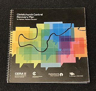
The Christchurch Central Recovery Plan, often referred to as the Blueprint, is the plan developed by the Fifth National Government of New Zealand for the recovery of the Christchurch Central City from a series of earthquakes, in particular the February 2011 Christchurch earthquake. The Canterbury Earthquake Response and Recovery Act 2010 required the Christchurch City Council to develop a recovery plan for the central city. The plan, known as Share an Idea, was presented to the Minister for Canterbury Earthquake Recovery, Gerry Brownlee, in December 2011. Brownlee rejected the city council's plan, established the Canterbury Earthquake Recovery Authority (CERA), and tasked that organisation with developing a plan based on the city council's draft. The Christchurch Central Recovery Plan was published in July 2012 and defined 17 anchor projects. All projects where a timeline was specified were to have been finished by 2017; none of the 17 projects have been delivered on time and some have not even been started yet.

Bus Interchange Bus station in Christchurch

The Bus Interchange is the bus station in the Christchurch Central City in New Zealand. Built as one of the 17 anchor projects identified in the Christchurch Central Recovery Plan, it opened in May 2015 after the previous Bus Exchange had been damaged in the 2011 Christchurch earthquake.

Waimakariri River Regional Park

Waimakariri River Regional Park is a regional park in the Canterbury Region of New Zealand's South Island. It covers 15,000 hectares on the banks of the Waimakariri River, and is operated by Environment Canterbury.

Northern Pegasus Bay

Northern Pegasus Bay is a regional park in the norther part of Canterbury's Pegasus Bay in New Zealand's South Island. It is operated by Environment Canterbury.

References

  1. Wood, Pauline (1993). Kaiapoi: A Search for Identity. Rangiora: Waimakariri District Council. ISBN   9780473023317.
  2. Bassett, Michael. "Story: Kirk, Norman Eric". Te Ara: The Encyclopedia of New Zealand . Retrieved 11 April 2021.
  3. "Removing the Kirk Street Reserve Playground". Waimakariri District Council . Retrieved 4 April 2021.
  4. 1 2 3 4 5 "Draft Reserves Master Plan: Kaiapoi Regeneration Areas" (PDF). Waimakariri District Council . Retrieved 4 April 2021.
  5. Christchurch Canterbury & 44 Towns Street Directory. Christchurch: 1999 New Zealand Minimaps Ltd. 1999. pp. 5–6. ISBN   1877201146.
  6. "1000 homes red zoned". The Press . Christchurch: Fairfax New Zealand. 18 August 2011. 0113-9762.
  7. Heather, Ben (19 August 2011). "Kaiapoi to loose 1 in 5 Homes". The Press . Christchurch: Fairfax New Zealand. p. A1. 0113-9762.
  8. Heather, Ben (18 January 2012). "Red-zoners 'bullied' in Govt buyout". The Press . Christchurch: Fairfax New Zealand. p. A1. 0113-9762.
  9. "Waimakariri Residential Red Zone Recovery Plan: He Mahere Whakarauora i te Whenua Rāhui o Waimakariri" (PDF). Department of the Prime Minister and Cabinet (New Zealand) . Retrieved 4 April 2021.
  10. "Five years on, the red zone is green". Stuff . Retrieved 4 April 2021.
  11. 1 2 "Regeneration Update – December 2018". Waimakariri District Council . Retrieved 4 April 2021.
  12. "Canvas: your thinking for the red zones" (PDF). Canterbury Earthquake Recovery Authority . Retrieved 4 April 2021.
  13. "Resources". Waimakariri District Council . Retrieved 4 April 2021.
  14. "Draft Waimakariri Residential Red Zone Recovery Plan/Te Mahere Whakarauora mō te Whenua Rāhui o Waimakariri" (PDF). Waimakariri District Council . Retrieved 4 April 2021.
  15. "Waimakariri Residential Red Zone Recovery Plan/He Mahere Whakarauora i teWhenua Rāhui o Waimakariri" (PDF). Department of the Prime Minister and Cabinet (New Zealand) . Retrieved 4 April 2021.
  16. "North Canterbury red zone land transferred from Crown to Waimakariri District Council". Stuff . Retrieved 4 April 2021.
  17. Hayward, Michael (16 June 2011). "Waimak's red-zone land handed over". The Press . Christchurch: Fairfax New Zealand. p. A5. 0113-9762.
  18. "Norman Kirk Park". Waimakariri District Council . Retrieved 4 April 2021.
  19. "Waimakariri council's quake response acknowledged with international award". Stuff . Retrieved 5 April 2021.
  20. "Kaiapoi: A journey from Quakes to Recovery" (PDF). Waimakariri District Council . Retrieved 4 April 2021.