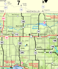
Jewell County is a county located in the U.S. state of Kansas. Its county seat and most populous city is Mankato. As of the 2020 census, the county population was 2,932. The county was named for Lewis Jewell, a lieutenant colonel of the 6th Regiment Kansas Volunteer Cavalry.

Cloud County is a county located in the U.S. state of Kansas. Its county seat and most populous city is Concordia. As of the 2020 census, the county population was 9,032. The county was named after William Cloud, an officer in the American Civil War.
Eden is an unincorporated community in Atchison County, Kansas, United States. It is about 5 miles west and 5 miles north of Atchison. It lies at the present-day intersection of Labette Rd, 322nd Rd, and 326th Rd.

Corbin is an unincorporated community in Sumner County, Kansas, United States. It is located about 6.5 miles northeast of Caldwell near the intersection of S Mayfield Rd and W 110th St S, next to the railroad.

Lyona is an unincorporated community in Liberty Township, Dickinson County, Kansas, United States. It is located on Wolf Rd approximately 8.7 miles (14.0 km) southwest of Junction City or 12.3 miles (19.8 km) north of Herington, also it is 1.5 miles (2.4 km) west of the Rock Springs 4-H Camp.

Sutphen is an unincorporated community in Dickinson County, Kansas, United States. It is located north of the intersection of 3100 Ave and Paint Rd.

Montrose is an unincorporated community in Jewell County, Kansas, United States.

K-148 is an 86.665-mile-long (139.474 km) state highway in the U.S. state of Kansas. K-148's western terminus is at K-28 north of Randall and the northern terminus is a continuation as Nebraska Highway 112 at the Nebraska state line. K-148 is signed as east–west its entire length although the last roughly 20 miles (32 km) runs north–south. Along the way K-148 intersects several major highways including U.S. Route 81 (US-81) east of Norway and US-36 south of Hanover. The highway travels through mostly rural land and small unincorporated communities, however it does pass through the cities of Agenda and Barnes.

Windhorst is an unincorporated community in Ford County, Kansas, United States. It is located along 131 Spur Rd between Iron Rd and Jewell Rd in a rural area between the communities of Bellefont and Bucklin, approximately 6 miles south of Bellefont or 15 miles north of Bucklin.

Aulne is an unincorporated community in Marion County, Kansas, United States. The Aulne name was suggested by officials of the railroad when it was built through Aulne during the 19th century. It is located southwest of Marion at the intersection of Pawnee Road and 140th Street next to the Union Pacific Railroad.
Clements is an unincorporated community in Chase County, Kansas, United States. It is located about halfway between Strong City and Florence near the intersection of U.S. Route 50 highway and G Rd.

Ashton is an unincorporated community in Walton Township, Sumner County, Kansas, United States. It is located about halfway between South Haven and Arkansas City at 1.75 miles north of the intersection of S Rock Rd and U.S. Route 166, which is 5.5 miles east of I-35, next to an abandoned railroad.
Otego is an unincorporated community in Jewell County, Kansas, United States.
Dillwyn is an unincorporated community in Stafford County, Kansas, United States. It is located southwest of St. John, next to a railroad at NW 10th Rd and NW 70th Ave, about 1 mile north of U.S. Route 50 highway.
Adamsville is an unincorporated community in Sumner County, Kansas, United States. It is located about 4 miles north of Geuda Springs at 0.5 mile west of the intersection of S Oxford Rd and E 80th St, next to an abandoned railroad.
Portland is an unincorporated community in Sumner County, Kansas, United States. It is located about 5 miles northeast of South Haven at 1.5 miles north of the intersection of S Hydraulic Rd and U.S. Route 166, next to an abandoned railroad. It is 1.5 miles east of I-35.
Riverdale is an unincorporated community in Sumner County, Kansas, United States. It is located about 6 miles southwest of Belle Plaine at the intersection of N Sand Plum Rd and 77th Ave N, or west of U.S. Route 81 next to the railroad.

Toledo is an unincorporated community in Chase County, Kansas, United States. It is located about 7 miles west of Emporia at the intersection of Yy Rd and 240 Rd.
Ottumwa is an unincorporated community in Coffey County, Kansas, United States. It is located along Iris Rd on the north side of John Redmond Reservoir.

Comiskey is a ghost town in Morris County, Kansas, United States. It was located approximately 6 miles (9.7 km) east of Council Grove, next to the county line.