Jewell, Kansas

Last updated

Jewell, Kansas
Jewell County Kansas Incorporated and Unincorporated areas Jewell Highlighted.svg
Location within Jewell County and Kansas
Map of Jewell Co, Ks, USA.png
Coordinates: 39°40′18″N98°09′09″W / 39.67167°N 98.15250°W / 39.67167; -98.15250 [1]
Country United States
State Kansas
County Jewell
Founded1870
Incorporated 1880
Named for Lewis Jewell
Area
[2]
  Total0.41 sq mi (1.06 km2)
  Land0.41 sq mi (1.06 km2)
  Water0.00 sq mi (0.00 km2)
Elevation
[1]
1,555 ft (474 m)
Population
 (2020) [3]
  Total370
  Density900/sq mi (350/km2)
Time zone UTC-6 (CST)
  Summer (DST) UTC-5 (CDT)
ZIP code
66949
Area code 785
FIPS code 20-35475
GNIS ID 2395470 [1]

Jewell is a city in Jewell County, Kansas, United States. [1] As of the 2020 census, the population of the city was 370. [3]

Contents

History

The City of Jewell began in 1870 as a large sod enclosure called Fort Jewell. Named in honor of Lieutenant-Colonel Lewis R. Jewell, Sixth Kansas Cavalry, who died November 30, 1862, of wounds received in the battle of Cane Hill, Ark. November 28, 1862. [4]

The first post office in Jewell was established in July 1870. [5]

Jewel was incorporated as a city in 1880. [6]

Jewell was located on the Missouri Pacific Railroad. [7]

A new community center was built in 1999 across from the city park, it features a Public library, American Legion offices and a 4-room hotel.[ citation needed ]

Geography

According to the United States Census Bureau, the city has a total area of 0.43 square miles (1.11 km2), all of it land. [8]

Demographics

Historical population
CensusPop.Note
1880 372
1890 70288.7%
1900 7364.8%
1910 83914.0%
1920 805−4.1%
1930 707−12.2%
1940 669−5.4%
1950 593−11.4%
1960 582−1.9%
1970 569−2.2%
1980 5893.5%
1990 529−10.2%
2000 483−8.7%
2010 432−10.6%
2020 370−14.4%
U.S. Decennial Census

2020 census

The 2020 United States census counted 370 people, 175 households, and 90 families in Jewell. [9] [10] The population density was 900.2 per square mile (347.6/km2). There were 224 housing units at an average density of 545.0 per square mile (210.4/km2). [10] [11] The racial makeup was 92.43% (342) white or European American (91.89% non-Hispanic white), 0.54% (2) black or African-American, 0.54% (2) Native American or Alaska Native, 0.0% (0) Asian, 0.0% (0) Pacific Islander or Native Hawaiian, 0.81% (3) from other races, and 5.68% (21) from two or more races. [12] Hispanic or Latino of any race was 2.43% (9) of the population. [13]

Of the 175 households, 16.0% had children under the age of 18; 45.1% were married couples living together; 28.0% had a female householder with no spouse or partner present. 45.1% of households consisted of individuals and 31.4% had someone living alone who was 65 years of age or older. [10] The average household size was 1.9 and the average family size was 2.5. [14] The percent of those with a bachelor’s degree or higher was estimated to be 12.7% of the population. [15]

19.7% of the population was under the age of 18, 5.7% from 18 to 24, 21.9% from 25 to 44, 24.6% from 45 to 64, and 28.1% who were 65 years of age or older. The median age was 47.7 years. For every 100 females, there were 98.9 males. [10] For every 100 females ages 18 and older, there were 99.3 males. [10]

The 2016-2020 5-year American Community Survey estimates show that the median household income was $37,679 (with a margin of error of +/- $4,925) and the median family income was $48,750 (+/- $10,446). [16] Males had a median income of $27,708 (+/- $2,813) versus $25,357 (+/- $10,087) for females. The median income for those above 16 years old was $26,518 (+/- $1,702). [17] Approximately, 13.0% of families and 19.0% of the population were below the poverty line, including 32.9% of those under the age of 18 and 18.0% of those ages 65 or over. [18] [19]

2010 census

As of the census [20] of 2010, there were 432 people, 208 households, and 113 families living in the city. The population density was 1,004.7 inhabitants per square mile (387.9/km2). There were 251 housing units at an average density of 583.7 per square mile (225.4/km2). The racial makeup of the city was 93.8% White, 1.9% Native American, 0.2% Asian, 0.2% from other races, and 3.9% from two or more races. Hispanic or Latino of any race were 5.6% of the population.

There were 208 households, of which 19.7% had children under the age of 18 living with them, 46.6% were married couples living together, 5.3% had a female householder with no husband present, 2.4% had a male householder with no wife present, and 45.7% were non-families. 42.8% of all households were made up of individuals, and 24.1% had someone living alone who was 65 years of age or older. The average household size was 2.08 and the average family size was 2.88.

The median age in the city was 49.2 years. 21.5% of residents were under the age of 18; 6% were between the ages of 18 and 24; 17.1% were from 25 to 44; 29.9% were from 45 to 64; and 25.7% were 65 years of age or older. The gender makeup of the city was 50.9% male and 49.1% female.

2000 census

As of the census [21] of 2000, there were 483 people, 224 households, and 133 families living in the city. The population density was 1,123.5 inhabitants per square mile (433.8/km2). There were 267 housing units at an average density of 621.1 per square mile (239.8/km2). The racial makeup of the city was 99.79% White, and 0.21% from two or more races. Hispanic or Latino of any race were 1.24% of the population.

There were 224 households, out of which 25.0% had children under the age of 18 living with them, 48.7% were married couples living together, 8.0% had a female householder with no husband present, and 40.6% were non-families. 35.3% of all households were made up of individuals, and 21.9% had someone living alone who was 65 years of age or older. The average household size was 2.16 and the average family size was 2.80.

In the city, the population was spread out, with 24.2% under the age of 18, 5.8% from 18 to 24, 22.6% from 25 to 44, 21.1% from 45 to 64, and 26.3% who were 65 years of age or older. The median age was 43 years. For every 100 females, there were 84.4 males. For every 100 females age 18 and over, there were 88.7 males.

The median income for a household in the city was $28,750, and the median income for a family was $34,063. Males had a median income of $28,125 versus $16,528 for females. The per capita income for the city was $15,713. About 13.0% of families and 18.0% of the population were below the poverty line, including 22.5% of those under age 18 and 18.3% of those age 65 or over.

Education

The community is served by Rock Hills USD 107 public school district, which was formed in 2006 by the consolidation of White Rock USD 104 and Mankato USD 278. [22]

Randall and Jewell schools were consolidated into Jewell-Randall schools in the 1960s. Prior to unification, the Jewell High School mascot was Jewell Wildcats. [23] The Jewell Wildcats won the following Kansas State High School championships:

Related Research Articles

<span class="mw-page-title-main">Glasco, Kansas</span> City in Cloud County, Kansas

Glasco is a city in Cloud County, Kansas, United States. As of the 2020 census, the population of the city was 441.

<span class="mw-page-title-main">Hepler, Kansas</span> City in Crawford County, Kansas

Hepler is a city in Crawford County, Kansas, United States. As of the 2020 census, the population of the city was 90.

<span class="mw-page-title-main">McCune, Kansas</span> City in Crawford County, Kansas

McCune is a city in Crawford County, Kansas, United States. As of the 2020 census, the population of the city was 370.

<span class="mw-page-title-main">Mulberry, Kansas</span> City in Crawford County, Kansas

Mulberry is a city in Crawford County, Kansas, United States. As of the 2020 census, the population of the city was 409.

<span class="mw-page-title-main">Jennings, Kansas</span> City in Decatur County, Kansas

Jennings is a city in Decatur County, Kansas, United States. As of the 2020 census, the population of the city was 81.

<span class="mw-page-title-main">Norcatur, Kansas</span> City in Decatur County, Kansas

Norcatur is a city in Decatur County, Kansas, United States. As of the 2020 census, the population of the city was 159.

<span class="mw-page-title-main">Gove City, Kansas</span> City in Gove County, Kansas

Gove City, more commonly known as Gove, is a city in and the county seat of Gove County, Kansas, United States. As of the 2020 census, the population of the city was 80.

<span class="mw-page-title-main">Burr Oak, Kansas</span> City in Jewell County, Kansas

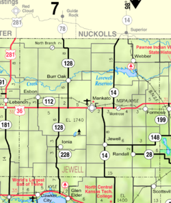
Burr Oak is a city in Jewell County, Kansas, United States. As of the 2020 census, the population of the city was 140.

<span class="mw-page-title-main">Esbon, Kansas</span> City in Jewell County, Kansas

Esbon is a city in Jewell County, Kansas, United States. As of the 2020 census, the population of the city was 69.

<span class="mw-page-title-main">Formoso, Kansas</span> City in Jewell County, Kansas

Formoso is a city in Jewell County, Kansas, United States. As of the 2020 census, the population of the city was 94.

<span class="mw-page-title-main">Mankato, Kansas</span> City in Jewell County, Kansas

Mankato is a city in and the county seat of Jewell County, Kansas, United States. As of the 2020 census, the population of the city was 836.

<span class="mw-page-title-main">Randall, Kansas</span> City in Jewell County, Kansas

Randall is a city in Jewell County, Kansas, United States. As of the 2020 census, the population of the city was 79.

<span class="mw-page-title-main">Norwich, Kansas</span> City in Kingman County, Kansas

Norwich is a city in Kingman County, Kansas, United States. As of the 2020 census, the population of the city was 444.

<span class="mw-page-title-main">Meade, Kansas</span> City in Meade County, Kansas

Meade is a city in and the county seat of Meade County, Kansas, United States. As of the 2020 census, the population of the city was 1,505.

<span class="mw-page-title-main">Ness City, Kansas</span> City in Ness County, Kansas

Ness City is a city in and the county seat of Ness County, Kansas, United States. As of the 2020 census, the population of the city was 1,329. Ness City is famous for its four-story Old Ness County Bank Building located downtown, and nicknamed Skyscraper of the Plains.

<span class="mw-page-title-main">Lyndon, Kansas</span> City in Osage County, Kansas

Lyndon is a city in, and the county seat of Osage County, Kansas, United States. As of the 2020 census, the population of the city was 1,037.

<span class="mw-page-title-main">Minneapolis, Kansas</span> City in Ottawa County, Kansas

Minneapolis is a city in and the county seat of Ottawa County, Kansas, United States. As of the 2020 census, the population of the city was 1,946.

<span class="mw-page-title-main">Onaga, Kansas</span> City in Pottawatomie County, Kansas

Onaga is a city in Pottawatomie County, Kansas, United States. As of the 2020 census, the population of the city was 679.

<span class="mw-page-title-main">Belleville, Kansas</span> City in Republic County, Kansas

Belleville is a city in and the county seat of Republic County, Kansas, United States. As of the 2020 census, the population of the city was 2,007.

<span class="mw-page-title-main">Clearwater, Kansas</span> City in Sedgwick County, Kansas

Clearwater is a city in Sedgwick County, Kansas, United States. As of the 2020 census, the population of the city was 2,653.

References

  1. 1 2 3 4 U.S. Geological Survey Geographic Names Information System: Jewell, Kansas
  2. "2019 U.S. Gazetteer Files". United States Census Bureau. Retrieved July 24, 2020.
  3. 1 2 "Profile of Jewell, Kansas in 2020". United States Census Bureau. Archived from the original on April 1, 2022. Retrieved April 1, 2022.
  4. "Profile for Jewell, Kansas". ePodunk. Archived from the original on July 14, 2014. Retrieved June 12, 2014.
  5. "Kansas Post Offices, 1828-1961". Kansas Historical Society. Retrieved June 11, 2014.
  6. Blackmar, Frank Wilson (1912). Kansas: A Cyclopedia of State History. Standard Publishing Company. p. 28.
  7. Gannett, Henry (1898). A Gazetteer of Kansas. Govt. Print. Off. p. 119.
  8. "US Gazetteer files 2010". United States Census Bureau. Archived from the original on July 2, 2012. Retrieved July 6, 2012.
  9. "US Census Bureau, Table P16: HOUSEHOLD TYPE". data.census.gov. Retrieved January 3, 2024.
  10. 1 2 3 4 5 "US Census Bureau, Table DP1: PROFILE OF GENERAL POPULATION AND HOUSING CHARACTERISTICS". data.census.gov. Retrieved January 3, 2024.
  11. Bureau, US Census. "Gazetteer Files". Census.gov. Retrieved December 30, 2023.
  12. "US Census Bureau, Table P1: RACE". data.census.gov. Retrieved January 3, 2024.
  13. "US Census Bureau, Table P2: HISPANIC OR LATINO, AND NOT HISPANIC OR LATINO BY RACE". data.census.gov. Retrieved January 3, 2024.
  14. "US Census Bureau, Table S1101: HOUSEHOLDS AND FAMILIES". data.census.gov. Retrieved January 3, 2024.
  15. "US Census Bureau, Table S1501: EDUCATIONAL ATTAINMENT". data.census.gov. Retrieved January 3, 2024.
  16. "US Census Bureau, Table S1903: MEDIAN INCOME IN THE PAST 12 MONTHS (IN 2020 INFLATION-ADJUSTED DOLLARS)". data.census.gov. Retrieved January 3, 2024.
  17. "US Census Bureau, Table S2001: EARNINGS IN THE PAST 12 MONTHS (IN 2020 INFLATION-ADJUSTED DOLLARS)". data.census.gov. Retrieved January 3, 2024.
  18. "US Census Bureau, Table S1701: POVERTY STATUS IN THE PAST 12 MONTHS". data.census.gov. Retrieved January 3, 2024.
  19. "US Census Bureau, Table S1702: POVERTY STATUS IN THE PAST 12 MONTHS OF FAMILIES". data.census.gov. Retrieved January 3, 2024.
  20. "U.S. Census website". United States Census Bureau . Retrieved July 6, 2012.
  21. "U.S. Census website". United States Census Bureau . Retrieved January 31, 2008.
  22. "School consolidations in Kansas for past decade". The Topeka Capital-Journal . July 24, 2011. Retrieved April 26, 2020.
  23. "Jamestown Set To Pickup The Marbles In PTL ", The Belleville Telescope, 8 December 1977, p.5.
  24. 1 2 3 "Track & Field". KSHSAA. Archived from the original on November 13, 2016. Retrieved January 6, 2017.

Further reading